
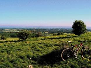
On this month’s ride with Nick Marks we take a trip over the Downs via Pyecombe and Clayton, taking in some fantastically varied riding and enjoying the Weald on the very cusp of summer. From now until the end of June is the best time of the year to savour the bucolic delights of Sussex: enjoy!
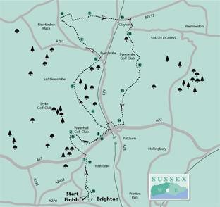
1 - Start at the cafe at Hove Park and head round the park, exiting at the top right-hand corner, and looking for a path leading up into the woods. Follow this track all the way up until you reach Dyke Road.
2 - Turn left, go over the roundabout, and head north towards Devil’s Dyke. When the road forks go right until you reach Waterhall Golf Club. Turn right down the drive, go across the car park, and find the track that leads down towards the rugby club. Then follow Waterhall Road for about half a mile until you see a bridlepath going up the hill on your left.
3 - Up the hill you go.
When you get to the top, look for a narrow path leading through the trees with a big iron gate. Once you’re on it follow that path for a mile and a half all the way to where it meets the South Downs Way. Turn right and head down to the A23. Cross over then follow the road round to the left, then go right up the lane marked “dead end”.
4 - When you get to Pyecombe Street, turn right and follow the road until it becomes a track. This will take you all the way past Wolstonbury Hill (worth a detour for the magnificent views) and back to tarmac again.
Follow the road round to the right, then look for a path that leads you back up into the woods. Turn left, and continue through dappled woodland until you see a path leading left back out of the woods again. Follow that until it becomes a gravelly track, turning right. The track turns into a road, which ends up at the Jack and Jill pub in Clayton. Half-time oranges?
5 - Turn right on to the Brighton Road, then immediately left on to New Road, then continue along past the garden furniture makers until you see a public footpath going left.
Opposite is a well hidden bridlepath that leads up past a collection of beautiful houses and on to Underhill Lane.
Almost as soon as you hit the lane you’ll see a footpath sign leading up the hill. There is supposedly a bridlepath, but I couldn’t find it; in any case I found the hill too steep to ride, and ended up walking up to the windmills.
6 - Once you’re there, go across the car park, then turn left up the hill for a couple of hundred metres. Take the path that leads off right, then go straight on. Ignore the South Downs Way going off to the right; just carry on south for as long as you can.
At one point you reach a T-junction in the middle of a field: turn left, continue up to the field boundary, then turn right and keep following the path. It then jinks to the left into a field of sheep.
Halfway down the side of this field you need to go right through the gate, then you’re home and dry. Follow the path over green wheat fields, past the Chattri War Memorial and down to the road.
7 - Turn right, then keep on the little lane as it takes you along parallel to the A27, before bearing right past some houses, and finally left over a footbridge from where you can watch the A23 traffic for a while. From here you drop down on to Waterhall Road, turning left and following it round to complete the loop.
The route back is the same way you came, finishing with a spectacular descent through the woods and back to Hove Park.
* Distance/Time: 18 miles, taking three to four hours.
* Surface: Grass, gravel, hard chalk, packed earth, tarmac.
* Your bike: Mountain bikes only
* Thirsty work: Jack and Jill pub in Clayton; Hove Park cafe.
* So you don’t get lost: OS Explorer map 122 (highly recommended for this ride).


Comments: Our rules
We want our comments to be a lively and valuable part of our community - a place where readers can debate and engage with the most important local issues. The ability to comment on our stories is a privilege, not a right, however, and that privilege may be withdrawn if it is abused or misused.
Please report any comments that break our rules.
Read the rules here