
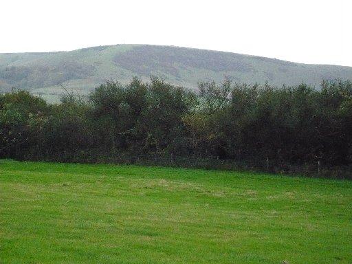
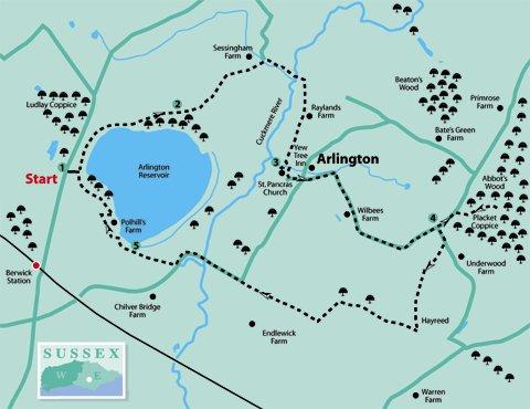
1 - This walk starts from Arlington Reservoir car park. The reservoir was constructed in 1971 to supply drinking water to Eastbourne and the surrounding area.
The Cuckmere River was straightened to its present course and the road re-aligned. (Note: this is the only river in Sussex where the name precedes the word river.) The reservoir is now a popular wintering location for wildfowl.
Facing the water, go to the information board and turn left along a wide track.
Keeping in the same direction where this footpath joins a bridleway, go to the top of a hill, and then continue straight ahead on this bridleway (not the footpath on the right, unless taking the limited mobility option of walking around the perimeter of the reservoir).
Go through a gate into a field, continuing downhill under power lines. At the bottom, turn right along the field edge until coming to and crossing a new bridleway bridge.
In a few paces, where a sign is pointing back to the reservoir, turn right along a byway. This leads to a large bridge over the Cuckmere River.
2 - Our route now joins the Wealdway, and in less than 100 yards after crossing the bridge, turn right over a stile by a WW sign. (The Wealdway is a regional route from the River Thames at Gravesend in Kent to the English Channel at Eastbourne.) Go straight ahead, under those power lines again, heading for and going through a metal gate to the right of a building. Continue in the same direction towards a church spire which can be seen ahead.
Go over a stile at the bottom of the field and turn left over another stile, and then bearing slightly to the right and over a third stile.
This leads to the churchyard of Arlington Church which has a rather unusual dedication to St Pancras (the patron saint of children), but bears no resemblance to its London namesake.
Part of the building dates back to Saxon times and is well worth a look in, if open, which it usually is during daytime. There are seats in the churchyard if a rest or picnic is desired at this point and if the weather is fine.
3 - Leave by the lychgate and turn left. At the road junction continue past the Yew Tree Inn and along the road, which in a short distance takes a sharp turn to the right.
Watch out for fast-moving traffic along this narrow winding road. In about 300 yards go past Wilbees Farm on the right and after a further approx 800 yards come to a road junction.
4 - If desired, there is an optional extra to visit Abbot’s Wood to use the picnic site and toilet facilities. Continue straight ahead for about 200 yards to find the entrance on the right. If using this as an alternative starting point for the walk, note the time when the gates are locked, and turn left at the exit and left again at the road junction.
Otherwise, turn right and in about 150 yards, immediately past the entrance to Windlebrook, turn right by a footpath sign. Go through a small wooden gate and along the left-hand edge of a private garden (this is a public right-of-way); then on through two wooden gates and into a small piece of woodland.
Go over a stile leading into a paddock, then after going over another stile bear slightly right to find and cross a footbridge at the bottom of the field.
From here, head uphill towards a metal gate in the top left-hand corner of the field.
Go through and straight across the next field, heading for Hayreed, the roofs of which can just be seen on the horizon.
Go over two stiles in close succession to the right of the buildings, which then leads to a lane. Turn right here, and in about 150 yards where the tarmac ends, continue straight ahead on the byway. These are ancient tracks, many of which pre-date the routes of our modern roads.
After a further 400 yards the byway bears round to the left. On coming to a T-junction turn right and continue to follow this byway for about half a mile until coming to a road.
Go straight ahead along the road, again beware of fast-moving traffic, and cross the bridge over the Cuckmere River again, which has become much wider at this point. Continue along the road for 250 yards, around the sharp left-hand bend to find and cross a stile to a footpath on the right.
Follow this across a field to a stile near the top left-hand corner and go over onto a bridleway. The reservoir perimeter path joins just beyond this point.
5 - If requiring a quick return to Berwick Station, turn left; then in about 100 yards, turn right through a kissing gate.
Follow the footpath across two fields, a footbridge and two more fields to emerge onto the road almost opposite the station.
Otherwise, turn right along the bridleway. On approaching a private property, follow the diversion between fences around the left-hand side of a house. This then continues along a wide grass track which leads back to the car park.
- Distance/Time: Five miles/two-and-a-half hours; an extra half mile/quarter-of-an-hour if going to and from Abbot’s Wood
- By Car: Arlington Reservoir car park (pay and display with toilet facilities), or park in roadside lay-by almost opposite car park entrance. Alternatively, use Abbot’s Wood car park and pick up the route at point 4, but be aware that the gates are locked at 6pm
- By Public Transport: Trains to Berwick; turn left at the station exit, walk along the road for 600 yards to the Reservoir car park
- What’s underfoot: Easy going on good mostly level paths, but expect some mud in places, if wet. Only suitable for baby buggies if taking the limited mobility option which rejoins the main route just beyond point 5
- Thirsty Work: Refreshment kiosk in Reservoir car park; Yew Tree Inn at Arlington; Inn opposite Berwick Station
- So you don’t get lost: OS Explorer 123 or Landranger 199
Click here for a full-sized map of the Arlington circular walk


Comments: Our rules
We want our comments to be a lively and valuable part of our community - a place where readers can debate and engage with the most important local issues. The ability to comment on our stories is a privilege, not a right, however, and that privilege may be withdrawn if it is abused or misused.
Please report any comments that break our rules.
Read the rules here