
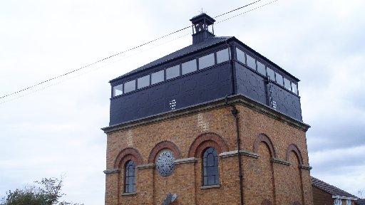
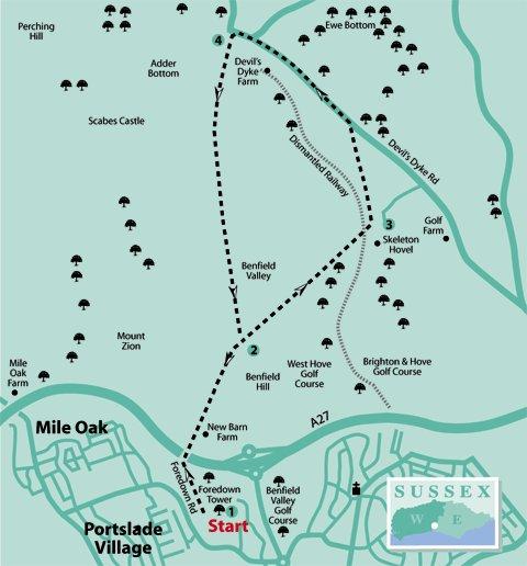
1 - The Foredown Tower, where this walk begins, is the sole remnant of the former Foredown Isolation Hospital.
The tower’s massive brick walls support the water tank that supplied the hospital with clean water and proudly display its manufacturer’s name – John Every, Engineer, at the famous Lewes ironworks.
From the tower, head north on the surfaced track. In a quarter of a mile cross right, over the bridge above the ever-busy A27 road, and continue down the slope.
Walk ahead between the buildings of New Barn Farm, now an equestrian centre.
The path passes across the low point of the Downland valley (muddy in places with all the horse traffic) and climbs Benfield Hill, to arrive beside a number of field gates, enclosing downland pasture.
2 - Keep direction across the top of the hill and descend into Benfield Valley. In the valley bottom, pass New Barn dewpond, with a track joining from the right.
Bear left through a squeeze-stile and climb up the eastern side of the valley.
When close to the summit cross the line of the dismantled railway that carried Victorian and Edwardian tourists to the Devil’s Dyke.
Continue up the now-easier slope to a bridleway junction, with the buildings of Brighton & Hove Golf Club off to the right. The area is shown on the map as Skeleton Hovel and the remains of the former downland farm are just visible.
Hovel is a term applied to a crude structure, perhaps lived in by agricultural workers. As for the skeleton, possibly a burial tomb existed hereabouts.
3 - Turn left on the bridleway, following this for half-a-mile to arrive beside the Dyke Road.
Cross to the opposite path, turning left on the gravel track and heading north-eastward, passing through a car park after a quarter of a mile.
Keep to the path for a similar distance, to a road junction.
Cross to the opposite corner, walking along a bank-top path beside the Dyke Road for 150 yards, just before a bend in the road cross left, passing through the opposite bridle gate.
4 - A big stride-out now begins as you follow the hilltop bridleway for nearly one and a half miles, with slopes dropping to Adder Bottom and Benfield Valley on right and left.
Pass through any intermediate gates, finally following an enclosed track across the last section of bridleway to the point we were at at stage one.
Turn right, down the track ascended earlier, passing between the buildings and climbing to the bridge, turning left back towards Foredown Tower.
There now, admit it, you feel much better for that...
- Distance/Time: Four and three-quarter miles, taking two and a half hours
- By Car: From Fox Way, in Portslade, turn north on to Foredown Road, limited car parking beside Foredown Tower visitor site. Start point grid reference TQ257071
- By Public Transport: Bus service runs along Fox Way, Portslade, walk from bus stop to Foredown Road and turn north to Foredown Tower, adds total of half-a-mile to the walk. Travel details from www.traveline.info, call 0871 2002233
- What’s underfoot: Generally good paths, expect some muddy sections in the lower valleys. A couple of easier climbs, otherwise easy walking. Possible with a baby backpack, not recommended with a baby buggy
- Thirsty Work: No refreshments available on the walk, hurry home for another mince pie and sherry
- So you don’t get lost: OS Explorer Map 122 plus a compass for general direction


Comments: Our rules
We want our comments to be a lively and valuable part of our community - a place where readers can debate and engage with the most important local issues. The ability to comment on our stories is a privilege, not a right, however, and that privilege may be withdrawn if it is abused or misused.
Please report any comments that break our rules.
Read the rules here