
1 - From the western end of Hove Lagoon, follow the narrow Basin Road North below the cliff-line. This area, formerly Wish Wharf, has fishing, timber importing and ship repair wharves – not too different from Turner’s time, but the technology and infrastructure has changed.
Keep to the busy road, which has working vehicles, warehouses, workshops and storage sheds. Occasional gaps in the buildings permit a view of the dockside scenes – take care at the quayside.
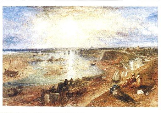
Follow the road for about half a mile, climbing to the main coast road, which can be seen in Turner’s work. Local residents may remember the sign that was on the building ahead – “John Eade Butt: Timber Importers.” The name Baltic Wharf was a clue to the origins of the imports. The wood stacked on the shore in the painting indicates longer-term continuity in this trade.
2 - From the traffic lights, continue west along the roadside. Note the road opposite – Boundary Road, Hove, on one side, Station Road on the Portslade side, a reminder that the two communities were once administered by their own councils, before the municipal colonialism of Brighton.
Keep to the pavement for 400 yards, descending to a second set of traffic lights, opposite Church Road. This junction marks the location of the old trackway, possibly a Roman road, which came across the Downs, through Portslade village to the harbour. The area was known as Copperas Gap and here iron pyrite nodules from the Sussex greensand beds were used to produce iron-sulphate, or copperas, used in the paper and textile industries.
In later times, when a gasworks was established on the opposite side of the harbour, a rowing boat ferry, known as the Gassie, carried workers across the harbour, thus avoiding a long trudge to work around the basin.
The dip in the coast road at Copperas Gap can be seen in the Turner painting, with buildings close by – clearly an important location at that time.
3 - Take a few paces left (beware of commercial traffic) and turn right along the under-cliff road, passing industrial units and marine ballast wharves.
On coming to the refinery area continue on the track, disregarding the faded restrictive notice on the gate (local dog walkers use the route) and continue for 250 yards to an open, harbour-side path. You are now within the community of Fishersgate (what is that a clue to?).
Keep to the wide gravelled track ahead, below the cliff line. Soon there is an option to keep to the grassy track, as the gravel runs out, or divert left to walk along the harbour edge – take great care of children and animals on this section. The path continues around a slight headland and the masts of moored yachts come into view at the Lady Bee Marina. Keep to the right and follow the narrow path below the cliff as you approach The Schooner pub.
4 - Follow the lower path, unless tempted by the pub, and pass by the Sussex Yacht Club buildings, noting an iron-strapped cottage tucked away on the right, with a tablet recording a date of 1816.
Climb a few paces right up a ramp, with the former red brick Southwick Town Hall on the right, at the roadside. Turn left, down beside the chandlery, and follow the access road through the industrial site to its far side.
On coming to a crossing road, and with the Port Authorities building on the right, turn left and in a few yards turn right around security fences, passing the dry dock and arriving beside the harbour lock gates.
5 - There are two main locks, one for smaller boats (The Prince George, built 1933), the first one you come to, and a larger lock (The Prince Philip, opened 1958) for cargo ships. It is an exciting moment if ships are passing through as the water levels are pumped to permit passage. Note the safety rules during lock operation.
No such facilities existed at the time of Turner’s painting and the harbour had previously been subject to the ebb and flow of the tides and the meandering erosion of the River Adur. In 1816, the harbour commissioners authorised a cut in the shingle bank, approximately where the harbour entrance now exists.
In 1850, well after Turner’s visit, the first lock gate, now the dry dock, was installed; in 1870 came the gasworks, followed by an electricity generating station in 1897 – Shoreham was becoming a serious industrial location for Sussex.
Follow the path from the locks, climb a short ramp to come to the beach-top path and take in the coastal view to Seaford Head and Seven Sisters.
6 - A diversion right leads to the east arm of the harbour entrance. Across the channel are the remains of Shoreham Fort. Return to the turn-off and head east along an almost straight path. In a few yards you arrive beside the legendary, and busy, Carat’s Cafe Bar – time for tea.
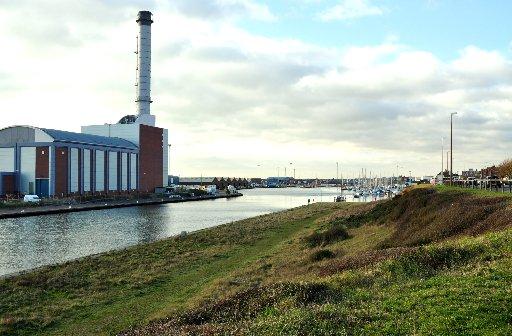
The left side of Turner’s painting shows the wide shingle spit, caused by longshore drift, that was to become the heavily industrialised and built-up part of the port. With gasworks, electricity generating stations and the huge timber and steel wharves of today, the artist would not recognize the scene.
Follow the bracing beach-edge path for one and a half miles, even dropping down to the sand at low tide. On approaching a bend in the road, divert left and then right, finally turning left, back to our starting point.
Time now to visit Petworth House to see the original painting to compare and contrast (see walks page on February 2).
- Eddie Start will lead a guided walk of Shoreham Harbour in aid of The Argus Appeal on Sunday, January 27 at 11am, meeting at the western end of Hove Lagoon, adjacent to Basin Road South. Suitable for walkers of all ages. Children must be accompanied by an adult and dogs must be kept on leads. Suggested donation £3. For more information email openspaces@mistral.co.uk
- Distance/Time: Four and a quarter miles, taking two and a quarter hours, including the diversion in stage 6.
- By Car: Turn off the A259 coast road into Wharf Road, beside Hove Lagoon. Car parking possible beside the lagoon. Start point grid ref: TQ269047
- By Public Transport: Bus stops close to Hove Lagoon, walk into approach drive to the start at west end of lagoon. Travel details from www.traveline.info, call 0871 2002233.
- What’s underfoot: Surfaced paths, roadsides and gravel tracks, plus a short section (stage 3) along a grassed surface. Suitable for single, not twin, cross-country buggies. OK with a baby backpack. Care required beside exposed harbour edges.
- Thirsty Work: Carat’s Cafe Bar at stage 6 and local pubs.
- So you don’t get lost: OS Explorer map 122 plus a compass for general direction.
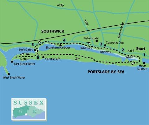
Click here for a full-sized map of the Shoreham circular walk


Comments: Our rules
We want our comments to be a lively and valuable part of our community - a place where readers can debate and engage with the most important local issues. The ability to comment on our stories is a privilege, not a right, however, and that privilege may be withdrawn if it is abused or misused.
Please report any comments that break our rules.
Read the rules here