
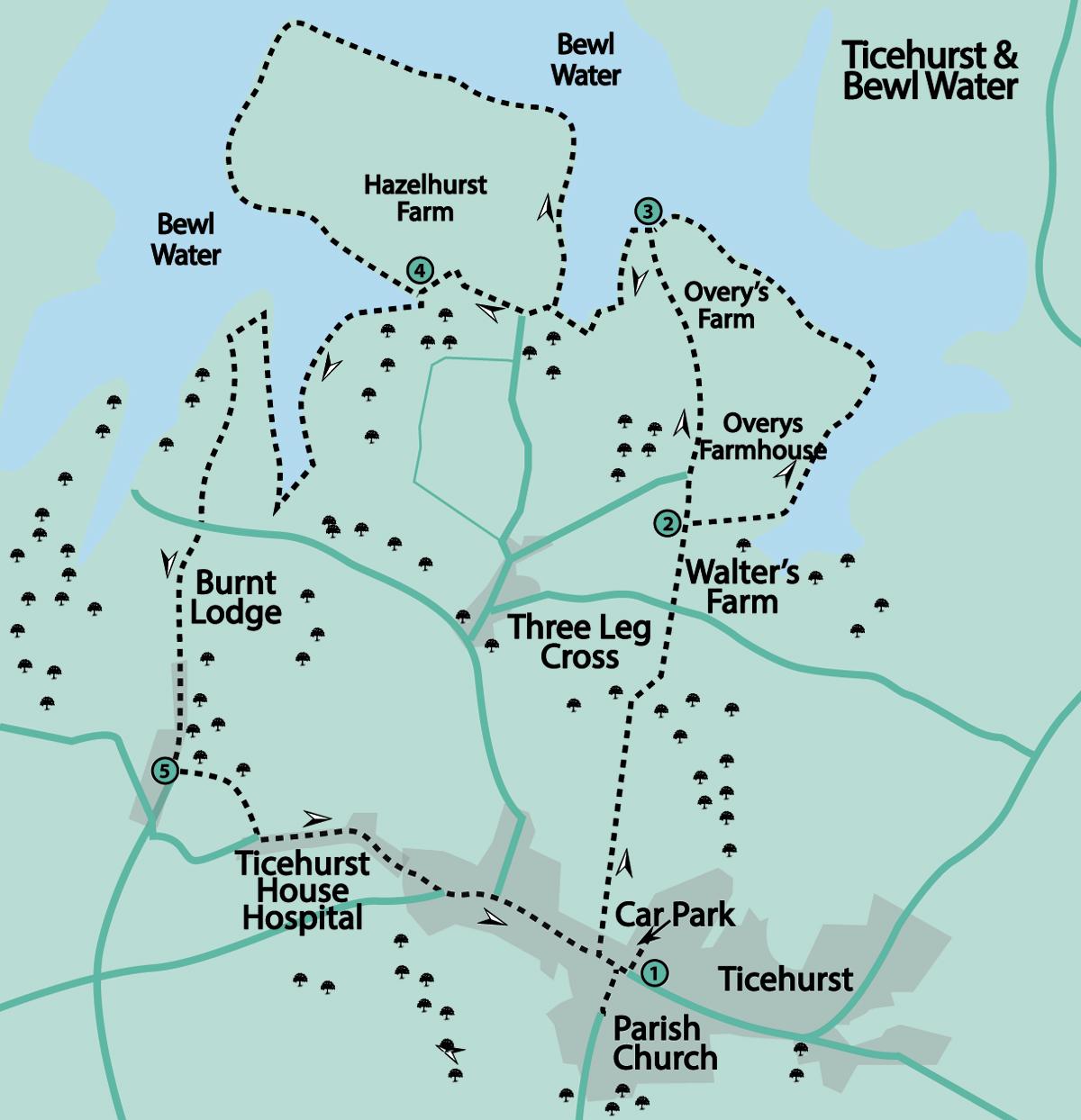
1 - If using the car park, return via Pickforde Lane to the main road (B2099) and turn right past The Bell Inn. If arriving by bus, facing The Bell Inn, turn left. There are toilets in the Square, opposite The Bell Inn.
Follow along the roadside path for about 75 yards and then look for a twitten between the walls opposite Old Hazelwood. There are footpath signs on the drainpipe and wall confirming this is a right-of-way.
Go past the sports ground on the right and continue along the footpath with a hedge on the left at first, then on the right. Bear right downhill through a small piece of woodland and on reaching a track; turn right. Then, almost immediately, turn left to continue on the footpath uphill to cross a minor road (Tinkers Lane).
Follow the restricted byway (open to all users except motorised vehicles) opposite to the right of Walter’s Farm. In about 200 yards, look for a signed bridleway which goes off to the right.
2 - There are then two options. To take the first option, turn right along the bridleway for 250 yards which tends to be very muddy, even when elsewhere is dry. At a T-junction, turn left on the Bewl Water perimeter route for three-quarters-of-a-mile to go past Overy’s Farm and then a small car park on the left before coming to the end of a road where the perimeter path continues to the right. This option offers a longer stretch along the water’s edge, including views to the reservoir’s eastern shore.
To take the second option, continue along the byway for about another 125 yards, and then turn right along a road (Huntley Mill Road) for 700 yards to go past Overy’s Farmhouse and Overy’s Farm on the right. This option is shorter but offers a view of Dunsters Mill House on the left. This Grade-II listed 15th century timber-framed building was moved up the hill to its present site to preserve it when the reservoir was built in the 1970s.
3 - On approaching the water’s edge, turn left to follow the Bewl Water perimeter path for a further 500 yards until reaching the entrance to the Nature Reserve. Here there are two further options.
For the shorter route, turn left through a wooden gate and uphill to cross a drive to follow the bridleway which bears right but to the left of the drive to Hazelhurst Farm. After a sharp left-hand turn, go downhill and through a gate on which there is another Nature Reserve notice.
For the other route, continue ahead into the Nature Reserve and follow the path close to the water’s edge on the right around the peninsular for nearly one-and-a-half miles. On reaching the bridleway again, turn right.
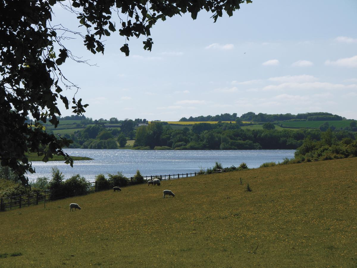
Various points along the water’s edge provide an ideal spot for a rest or a picnic. Allow extra time for watching and/or photographing the wildfowl here.
4 - Continue downhill over a substantial bridge, and then follow the perimeter route close to the water’s edge for another three-quarters-of-a-mile; heading south at first, then north and then south again as the route follows the reservoir’s inlets and promontories. Leave the Nature Reserve through a gate and continue up the road (Lower Hazelhurst) ahead.
Ignore two roads on the left which lead to Three Leg Cross. Follow the road ahead, which now becomes Burnt Lodge Lane and then in a quarter-of-a-mile past Burnt Lodge Farm on the right, look for a hidden footpath plinth in the hedgerow on the left.
5 - Go over the stile and follow the left-hand field edge, then over another stile and alongside a board fence on the right. Cross a gravel driveway to continue on the footpath in the same direction.
Ignore a footpath on the left and follow the footpath uphill along the field edge to go over a stile. Turn left along the road (Vineyard Lane) to pass a very prominent building on the right, Ticehurst House, which was built in the late 18th century, and is now an independent hospital.
On reaching the main road, turn left along the footway. Notice the village sign with its tree, the hurst part of the village name deriving from the Old English “hyrst”, meaning a wooded area.
Follow the footway until coming to the twitten used at the beginning of the walk. Cross the road here and continue in the same direction, then turn right into Church Street.
Cross over to enter the churchyard to see the Parish Church dedicated to St Mary the Virgin. There is evidence of a church existing on this site from the late 12th century. However, the present building dates from the late 14th century with many additions and alterations which date from the Victorian era.
The most recent extension was constructed in this century and has been designed to blend very well with the existing building. The church is usually open from 9am to 4pm daily so look inside to see, amongst other things, the wood carvings which were made by Mouseman Thompson of Kilburn, Yorkshire.
Return to Church Street and turn right to the High Street for the bus stop or to Pickforde Lane for the car park. If time permits, also take a look around the village at some of the old buildings here.
- Distance/Time: Minimum four-and-a-half miles/two-and- a-quarter hours; Maximum six miles/three hours; depending on which options are taken between points 2, 3 and 4
- By Car: Car park (free) in Pickforde Lane (off High Street, B2099).
- By Public Transport: Buses (254) from Wadhurst and Hawkhurst to Ticehurst, alight at The Bell Inn. Timetable information from Traveline: 0871 200 2233 or www.traveline.info
- What’s underfoot: Field and woodland paths and tracks which are likely to be muddy, if wet; very few stiles; some minor roads.
- Thirsty Work: The Bell Inn, High Street, Ticehurst (at start/finish).
- So you don’t get lost: OS Explorer 136 and Landranger 188 or 199; also a compass for general direction
Click here for a full-sized map of the Ticehurst circular walk


Comments: Our rules
We want our comments to be a lively and valuable part of our community - a place where readers can debate and engage with the most important local issues. The ability to comment on our stories is a privilege, not a right, however, and that privilege may be withdrawn if it is abused or misused.
Please report any comments that break our rules.
Read the rules here