
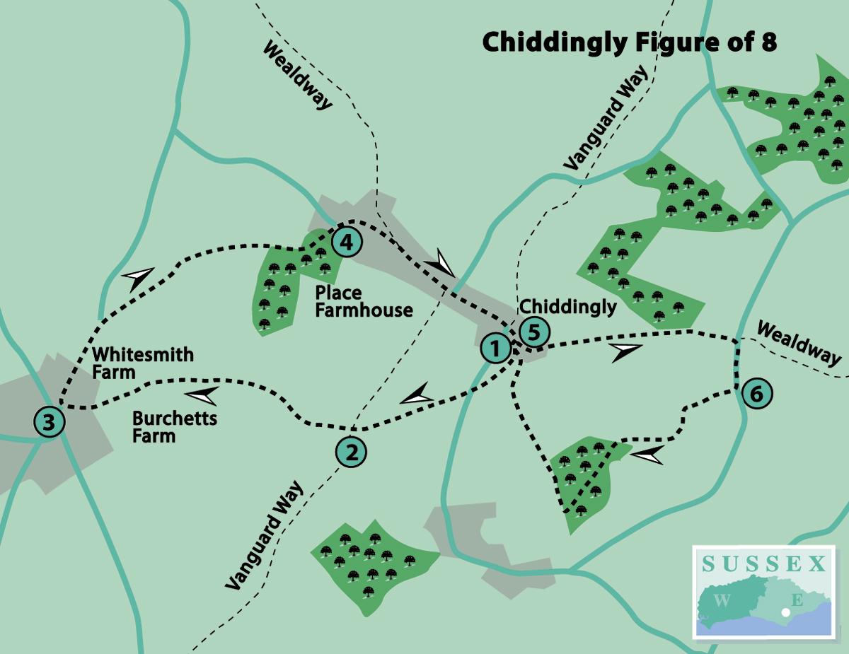
1 - For the first part of the walk, from the car park, go to the main gate into the churchyard. Straight ahead is the war memorial; the roll of honour may be viewed within the church. Look up at the church building, well-known for its tall stone spire, which is a landmark for miles around. The church welcomes visitors, so take a look inside, if open.
Go up the path to the right of the building, then veer right across the grass and over a stile into the cricket field. There is a VGW waymark here, indicating that this path is part of the Vanguard Way, a route of 66 miles from East Croydon to Newhaven, created to celebrate the 15th anniversary of the Vanguards Rambling Club in 1980, encountered on some of my previous walks.
Keep to the right-hand edge, passing the pavilion, and go through a gate on the right on to a road. Cross and turn left, then in a few paces turn right to go over a footbridge and stile. Bear left across the field to the farther left-hand corner, heading towards woodland.
Go through a field gate, bear right to go over a stile and then straight ahead through a small piece of woodland. On coming to a fingerpost, continue straight ahead, leaving the Vanguard Way, which goes off to the left at this point.
2 - Follow the right-hand field edge for about a quarter of a mile, crossing a small stream into the next field. Continue along the field edge until entering another field.
Now begin to bear left across the field on a clear wide path to the farther left-hand corner, but to the right of buildings at Burchetts Farm. The large wheel seen on the left is a prototype wind engine. This way is longer but avoids an awkward and disputed route through Whitesmith Farm. Exit the field on to a concrete track, keeping direction towards a minor road.
3 - Turn right along the road (Whitesmith Lane) for 350 yards. Just past a five-bar field gate, turn right over a somewhat overgrown stile. Bear left across the field to go over another stile.
Continue to the left along a wide path between fences to the corner of the field. Cross a wide bridge over a stream and bear right uphill to cross a hidden stile, about 30 yards to the right of a five-bar gate.
Bear right to cross a make-shift stile in a broken field-edge fence. Cross a stile ahead, then go straight along the field edge to cross another stile.
Continue ahead, bearing left (north-east) through woodland. On leaving the wood through a gate, go across a small field to the farther right-hand corner and through another gate on to a road (Highlands Lane).
4 - Turn right along the road. In 200 yards, a white painted stone will be seen on the left, as well as a fingerpost indicating that the Wealdway (WW) goes off to the left here. This is another regional route, encountered on some of my previous walks, extending for 80 miles from Gravesend in Kent to the Sussex coast at Eastbourne.
However, our route is on the part of the Wealdway which continues along the road straight ahead. In a further 300 yards, see the old Place Farmhouse on the right, a Grade II listed building which is part of a 16th-century mansion.
Just past here, at the road junction, continue straight ahead by the 30mph speed limit sign and at the sharp right-hand bend, turn left opposite The Six Bells pub (unless going in) to return to the car park.
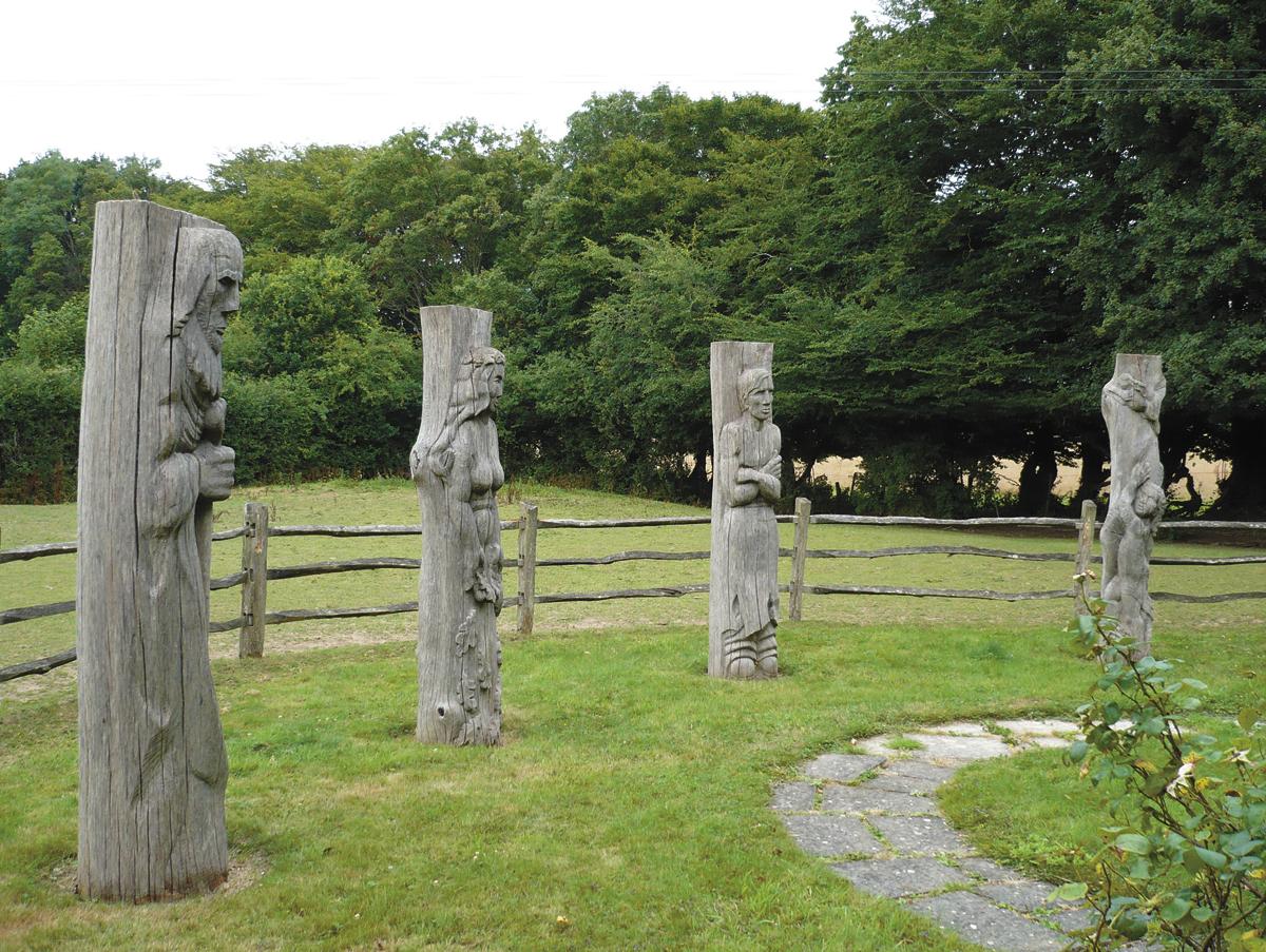
5 - On entering the car park, go through a wooden gate on the left into the Millennium Garden. Here can be seen some unusual life-size wood sculptures and various plaques and inscriptions about the garden. This is also a good place to have a picnic.
To start the second part of the walk, go up the slope at the farther end of the car park, on to the drive leading to the Village Hall. Almost immediately, turn left through a small gate and bear slightly right on the cross-field path, which is a continuation of the Wealdway.
Aim for the isolated, redundant stile in the middle of the field, then keep direction downhill to go over a stile into woodland. Follow the path which leads over a footbridge uphill and over another stile.
Continue straight ahead across the field and down a slope, through a gate and on to a road. Here we leave the Wealdway and turn right downhill.
6 - In 150 yards, turn right along a track towards Little Park Farm. Immediately past a house on the right, turn left over a stile on to a grass path. In about 350 yards, follow the path as it bears left downhill over a long footbridge between two ponds.
Follow the winding path through the wood for about 300 yards. On reaching the edge of the wood, do not go over the stile ahead, but turn right on a clear path.
Leave the wood over a footbridge and continue along the right-hand field edge. Cross a stile into the cricket field, encountered earlier, and bear right towards the church.
Turn right into the churchyard, then follow the path round to the left and out of the main gate to return to the car park.
Distance/Time: First part – two and a half miles/one and a quarter hours; second part – two miles/one hour
By Car: Car park (free) in Chiddingly village, approached from the A22, between the Boship roundabout and Golden Cross
By Public Transport: Sorry, none available
What’s underfoot: Fairly flat farmland and woodland paths and tracks which are likely to be muddy, if wet; also a short distance on minor roads
Thirsty Work: The Six Bells pub, Chiddingly (closed between 3pm and 6pm on weekdays) at start/finish.
So you don’t get lost: OS Explorer 123 or Landranger 199, plus a compass for general direction
Click here for a full-sized map of the Chiddingly walk
- Chiddingly Festival takes place from September 26 to October 6. Visit www.chiddinglyfestival.co.uk for more information.


Comments: Our rules
We want our comments to be a lively and valuable part of our community - a place where readers can debate and engage with the most important local issues. The ability to comment on our stories is a privilege, not a right, however, and that privilege may be withdrawn if it is abused or misused.
Please report any comments that break our rules.
Read the rules here