
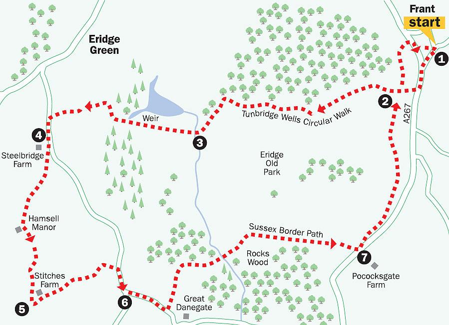
Most of this fairly substantial and moderately strenuous walk lies within Eridge Old Park. Thought to be one of the oldest deer parks in the country, the Nevill Estate has, with grants from the government, commenced a programme of scrub clearance and new tree-planting designed to encourage these delightful animals to thrive here.
The clearance work has led to the erosion of some of the paths by timber-hauling, so you need to be prepared for some mud and uneven ground in places.
The same grant scheme has, usefully, allowed the establishment of some new routes for walkers within the park, one of which we use on this circuit from point seven back to Frant.
Although this additional route is not marked on the OS Explorer map, it is indicated by waymarks and on notices posted at the beginning and end of the path.
Additionally, you might like to arm yourself with a map showing the permissive path, downloadable from the DEFRA website under the section labelled Conservation Walks.
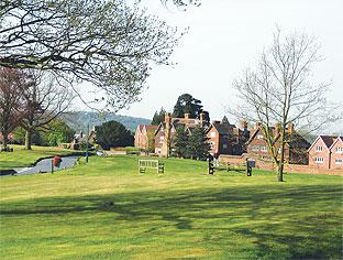
1. To start the walk, make your way to the southern end of the large village green at Frant, where you can join the A267 and turn left beside it, walking in the Heathfield direction.
After about 100 yards, turn right along a narrow, fenced path signed to Eridge Green.
2. At a junction with a rutted track, turn left and, after a few yards, go right through a gate in a high deer-fence and follow a well-trodden path which heads out across Old Eridge Park, soon passing along the right edge of pasture and on through woodland.
Follow this well-established path, signed as part of the Tunbridge Wells Circular Walk, as it bears right and continues through an area of cleared woodland where the track has been badly eroded by timber-hauling vehicles.
Pass to the right of a large pond and left along the earth dam at the far end. Through a swing gate, turn right along the right edge of open parkland.
Go through another deer fence gate and turn left with this fence to your left and a wood on your right.
3. Shortly, join and go ahead along a track which crosses a culvert where there is a small circular weir on the left. After a few yards, go ahead across a field towards a waypost on the skyline, marking the path.
On the other side of this large field, go ahead along a hard-surfaced drive for a few yards only and then fork left along a narrower woodland path.
After about 250 yards, cross a drive, follow the path ahead for 30 yards and then, where the Tunbridge Wells Circular Walk goes ahead, you should turn left over a stile.
Follow the right edge of three fields, with a stream nearby on your right, to join a road and turn left.
4. After a little more than 200 yards, turn right into the entrance to Steelbridge Farm and then immediately go left over a stile and head diagonally across the middle of a field.
In the far corner feed into a fenced, grassy strip with a wood on your left. Where this enclosed path ends, go over a stile and head out across a field, diverging at about 20 degrees from the hedge on your right.
On the other side of the field, cross a plank bridge in a dip to join and bear left along a tarmac drive. At the entrance to Hamsell Manor on your right, bear left with the drive and, where it divides, fork right.
5. After another half-a-mile or so, just past the main buildings at Stitches Farm, turn left along a concrete drive, leaving an open-sided barn on your right.
Skirt to the right of a brick shed and bear left behind the farm buildings.
Shortly veer right to enter a short overgrown path between low banks which, after a few yards, opens out into a field. Go ahead along the left field-edge to a gap and on in the same direction across the field. Join and follow the upper-right field-edge and then cross another field.
On the other side go ahead along a narrow path. If overgrown and impassable, you can escape up a bank into the field on the right. Either way, after about 100 yards, turn right and follow the left fieldedge uphill to join a lane, where you should turn right.
6. At a road junction, fork left along Danegate and, after another 400 yards, turn left along a wide fenced grass strip, signed as a footpath to Pococksgate Farm. Follow the well-signed path round to the right and down through woodland, following way marks carefully.
After leaving the wood, turn right, soon climbing steadily along the right edge of more open parkland. At the top, cross a cattle grid and follow the track ahead.
7. When you are about 30 yards short of the A267, you can turn left along a permissive Countryside Stewardship path, which runs within woodland, parallel to and about 50 yards away from the main road on your right.
On reaching a crossing dirt track, turn left for 20 yards, then right along the upper edge of a grassy slope.
Towards the field corner, follow a track as it curves right into woodland and, after 60 yards, following the direction of an arrow on a tree, go left.
An indistinct path meanders through a wooded dip and climbs again, bearing leftwards and becoming more obvious as a track used by vehicles, which you can follow back to point 2.
Go ahead here, still along the track, pass through a deer fence gate and turn right to follow the fence up and round to the left.
After about 250 yards, go right through a similar gate and uphill to reach the A267 at Frant, almost opposite the Abergavenny Arms Hotel.
Turn right back to the village green and the start.
- Distance/time: Seven-and-a-half miles/three to four hours.
- By car: Start from the village of Frant, about two miles south of Tunbridge Wells on the A267. Roadside parking is possible in various places around the large village green at GR 590354.
- By public transport: Bus from Tunbridge Wells.
- What’s underfoot: Mostly along well-established paths and tracks, some eroded and likely to be muddy after rain.
- Thirsty work: Two pubs at Frant.
- So you don’t get lost: OS Explorer 135.
For a larger version of the map, see 'related links' above.


Comments: Our rules
We want our comments to be a lively and valuable part of our community - a place where readers can debate and engage with the most important local issues. The ability to comment on our stories is a privilege, not a right, however, and that privilege may be withdrawn if it is abused or misused.
Please report any comments that break our rules.
Read the rules here