
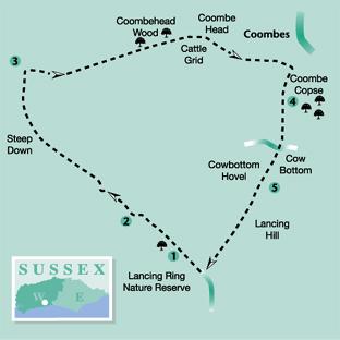
This shorter walk by Eddie Start is ideal for those who need an evening stroll after a hectic day. It provides an opportunity to look down on a busy world and take in a wider view across sea, coastline and countryside – a bit of a reflective ramble. Ascent and descent are on the bill, along with a feeling of wellbeing at the finish.
1 From the car park at Lancing Ring Nature Reserve walk out on to the rough approach track, through one of the several exit points, and turn left. In a few yards the track is joined by another, coming from the right. At this point turn left up the gradually rising flint byway.
With hedgerow on the left and paths leading off into the reserve, the track soon levels and proceeds through a tree-tunnel, along the edge of the hilltop copse. On clearing the tree cover, a broad downland landscape opens-up. Continue ahead for 250 yards on the slightly descending path and at the end of a thin left hedgerow turn left for a few yards. From a marker post on the left at a hedge corner, turn sharply right across a field-centre path.
2 The path swings slightly to the left as it reaches the bottom of the field and arrives at a junction of four paths. Turn right for about 75 yards, do not walk as far as the prominent marker post on the skyline but turn left on the unsigned bridleway to begin the long ascent of Steep Down. The climb, between arable fields, levels-off after 400 yards with a more gradual, breath-recovery approach to the summit at 489ft. On arriving at the hilltop trig point there is a chance to look around a broad landscape, from the glinting sea and cliffs off to the east, the urban coastal sprawl with its sky-piercing tower blocks and the wide, fold-upon-fold rolling downland; to the north is the tantalisingly distant purple haze of the Weald.
From the trig point, follow the hilltop track across the summit and descend to a bridle gate. Continue down an enclosed bridleway to a second gate, after which branch left to pass beneath power cables and to the left of a pylon.
3 In about 50 yards turn right through a gate along the bridleway, at first following the right hedgeline and, when this finishes, continue on the wide track beside a fence.
This is an easy path to follow, with the steep side of Winding Bottom on the left and a continuing delightful, expansive downland vista. This is good grazing country and in season there are flocks of sheep making the most of the succulent grass. Shepherds can sometimes be seen, using modern forms of transport to reach their flocks but their tasks are much the same as those of earlier pastoralists who roamed these hills on foot on wide droving tracks, taking their flocks to fresh pasture and leading a hard, rustic lifestyle that is now long gone.
The track heads towards Coombe Head and the obvious Coombehead Wood, a prominent, sheltering copse on the left and perhaps a place to make for if bad weather threatens.
Keep to the fenceline, unless you decide to investigate the wood, turning to the half-right and making for a bridle gate, next to a metal cattle grid. Pass through the gate and continue straight ahead, down the right fenceline, with the steep sides of a coombe on the left.
At the lower end of the coombe is the tiny community of Coombes, with its charmingly tranquil and humble downland church and a busy and popular farm. There is also a reminder of a more recent industry in the opposite hill, to the east, at the now silent Beeding cement works with its tall, gaunt structures and deep excavations.
4 The hilltop path finally arrives at a field corner beside metal gates next to Coombes Copse. Cross the stile on the right and immediately turn right on a footpath for a few yards to a field corner.
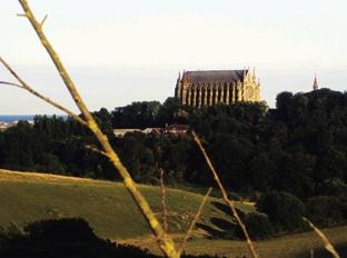
From the corner, turn left along the field-edge and walk over the top of the hill, keeping a southerly line and crossing a stile close to a lone crack willow tree on the left of the path. From this section of the trail there are views down the Adur valley to the coast, the regular air traffic arriving and leaving Shoreham Airport and the ever-prominent structure of Lancing College chapel dominating the skyline.
After a quarter-of-a-mile, at a collection of gates with field tracks leading off, pass through the centre, wide kissing gate and follow the enclosed path, which soon dips to a crossing, surfaced farm track.
Descend ahead, more steeply now, into Cow Bottom to arrive at the prominent flint-built structure of Cowbottom Hovel – a high-walled animal enclosure that has clearly been an important piece of agricultural infrastructure in the past.
5 At the far side of the valley floor, having passed by the enclosure, cross a stile and climb the steep footpath to arrive at a stile, close to the top of Lancing Hill.
Cross into the next field and follow a quarter-right line over the top of the hill on a trodden path, finally descending to a gap in a hedge. Follow the dipping path into the bottom of a shallow hollow, with a paddock on the right, then climb to a stile leading on to a rough track.
Turn right for a few yards then turn left on a grassy path above a former quarry, passing a metal fence that is on the left. In a few yards the path arrives at the approach road to the car park, from where the walk began.
Turn right for a few paces to the car park, or go left to descend to Mill Hill and local bus services and the residential area of Lancing.
Distance/Time: Four-and-a-half miles taking two-and-a-quarter hours.
By Car: Leave the A27 going north from the roundabout next to Lancing Leisure Centre and Park on to Manor Road, pass the pub and turn right (north) into Mill Road. Follow Mill Road to the top of the hill; continue ahead on the rougher track to the car park (height restriction) at Lancing Ring Nature Reserve. Start point Grid Ref. TQ183063 By Public Transport: Bus details from www.traveline.info or phone 0871 2002233. Bus stops in Mill Road.
What’s underfoot: Downland walking on well-drained paths, two hill climbs, otherwise no real challenges. Possible with a baby backpack, but not a baby buggy.
Thirsty Work: The Miller and Carter pub, Lancing village, close to the park.
So you don’t get lost: O.S. Explorer maps 121 and 122, plus a compass for general direction.


Comments: Our rules
We want our comments to be a lively and valuable part of our community - a place where readers can debate and engage with the most important local issues. The ability to comment on our stories is a privilege, not a right, however, and that privilege may be withdrawn if it is abused or misused.
Please report any comments that break our rules.
Read the rules here