
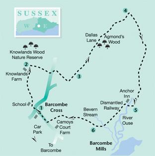
This easy stroll offers plenty of variety and interest. From Barcombe, it heads north east to pass through immaculately maintained oak woodland before turning south beside the River Ouse, along a picturesque riverside path, to reach the Anchor Inn.
1 - From the entrance to the Barcombe village car park, turn right and, at a mini-roundabout, bear left and shortly fork left again along a no through road (School Path), following it as it bears right in front of the entrance to the village school.
From the end of the lane, go ahead along a right field-edge where a generous grass headland has been preserved, a characteristic feature of the area thanks to the Countryside Stewardship Scheme.
From the field corner, go forward through two new bridle gates, over a concrete bridge, then through a third gate and ahead along the left edge of a meadow to a stile beside a gate and on beside a right-hand hedge.
In the next field corner go over a plank bridge and stile and head out across pasture, walking parallel and close to the left field-edge. In the field corner, join a farm track.
A short there-and-back detour to the left from this point allows access to Knowlands Wood, a privately managed nature reserve to which the public are permitted access on foot.
2 - To continue the walk, turn right to follow the track between the buildings at Knowlands Farm and on along the access drive, passing a large pond to reach a road at Mount Pleasant.
Turn left and, after 60 yards, turn right into the drive to Forge Cottage, enter a short enclosed path to a stile and continue gently downhill along a left field-edge where a good view opens up southwards to the Downs.
At the bottom of the hill, go over a stile and plank bridge and veer half-right up a bank and on to a gate, continuing along a right field-edge as you skirt to the left of farm buildings. Cross another small field to join a lane over a stile and turn left.
3 - After about 200 yards, where the lane bends right, go ahead along Dallas Lane, signed as a private road though it is also a public right of way. Where the lane ends beyond a group of houses, go over a gate with a built-in stile and along a wide track.
At a meeting of several tracks, go ahead through the well- maintained Agmond’s Wood where there has been much replanting in the gaps between some fine mature oak trees. After eventually leaving the wood, a hard track continues.
4 - After another 400 yards, just short of the point where this track enters woodland once again, turn right through a squeeze stile next to a gate where the path is waymarked as part of the Sussex Ouse Valley Way, a recently devised 42-mile, long-distance route following the River Ouse from its source near Lower Beeding to the sea at Newhaven.
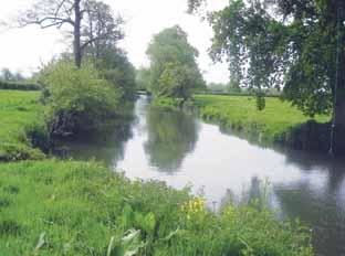
With the River Ouse nearby on your left, follow the well-trodden path through several fields. After about half a mile, join a track, turn left across the river at White Bridge and immediately turn right to follow the Ouse again, now on your right, downstream for more than a mile, a delightful riverside walk, passing, en route, under a bridge which once carried the railway linking Lewes with Uckfield.
5 - At the Anchor Inn, turn right across the river.
The pub was built in 1790 to accommodate the barge of traffic which once passed to and fro along the Ouse, a busy navigation during the first half of the 19th century. It is now a popular summer destination, offering good food and drink as well as rowing boat hire during the warmer months.
Follow the lane from the pub. After about 200 yards, turn left along a path, signed as a licensed path to Barcombe Mills, which uses the track bed of the old railway which once linked Lewes and Uckfield, reduced at this point to a fairly narrow path.
After about 250 yards, fork right along a narrow path though trees to a stile, then turn left along a track for ten yards only before forking right to follow a left field-edge, walking parallel to the old railway, over the fence on your left.
After 300 yards, the path bears right to reach a stile. Cross the corner of a field to pass over a bridge across the Bevern Stream, marked as Beam Bridge on the Explorer Map.
6 - Over the bridge, turn right, and after about 50 yards, right again over a stile, to follow a permissive path, not marked on the map but available for public use under the Countryside Stewardship Scheme, at least until 2013. To obtain a print-out of the map showing this path, go to the DEFRA website and search in the walks and rides section for Camoys Farm, East Sussex.
This well-trodden path continues along the valley, never far from the modest Bevern Stream on your right. After about a quarter of a mile, go over a stile and ahead with a fence on your left, soon ignoring paths to left and right.
Climb gently along a broad headland chalk track to join a road and turn right for less than a quarter of a mile, back into Barcombe.
- DISTANCE/TIME: Five-and-a-half miles taking two-and-a-half hours.
- BY CAR: Start from the village of Barcombe (labelled as Barcombe Cross on OS maps). Barcombe is signposted eastwards from the A275 about three miles north of Lewes. Park in the village car park at GR 421158.
- BY PUBLIC TRANSPORT: Hourly weekday bus service from Lewes to Barcombe.
- WHAT’S UNDERFOOT: Easy, level walking along good, generally well-signed paths. An excellent family stroll.
- THIRSTY WORK: Pub at Barcombe Cross. Anchor Inn at point 5.
- SO YOU DON’T GET LOST: OS Explorer 122.


Comments: Our rules
We want our comments to be a lively and valuable part of our community - a place where readers can debate and engage with the most important local issues. The ability to comment on our stories is a privilege, not a right, however, and that privilege may be withdrawn if it is abused or misused.
Please report any comments that break our rules.
Read the rules here