
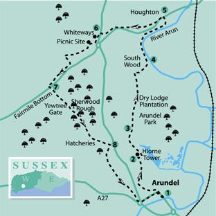
1 - From Arundel Bridge turn north-west into the High Street, passing shops and climbing steeply with the castle wall on the right.
At the top of the hill, with the castle gates on the right, turn left along London Road. Pass the parish church and Catholic cathedral and after a quarter-of-a-mile, just beyond a primary school, arrive opposite the entrance to Arundel Castle Cricket Club. Turn right into the entrance drive, going northwards beside a high wall and estate buildings. Pass through the brown double gates in front of an imposing lodge in 250 yards. Keep to the main driveway, with open parkland on the right, to arrive beside a stubby marker post (yellow arrow) on the right, after a quarter-of-a-mile.
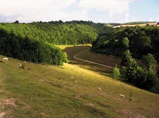
2 - Leave the drive, going right, with the Hiorne Tower on the left, and walk across the parkland, crossing horse gallops at the far side. Descend a short, steep track through scrub and go left over a stile. A wide view now opens up across a deep valley. Follow the chalk track, descending across the hillside, passing through the edge of woodland, and continuing to crossing tracks in the valley bottom. From the marker post take the half-left track indicated, climbing the steep bank.
3 - Follow the trodden chalk steps to a stile and footpath sign on the skyline, then take the less steep, grassy path across the hillside. There is evidence of ancient field systems all around. Keep direction up the hill, passing a stand of rare oaks and continuing to a second cluster beside a fence. Cross a stile and continue towards the edge of the hilltop Dry Lodge Plantation. Turn left along the woodland edge, taking in the view south to the coast. At the corner of the plantation, in 150 yards, maintain direction, descending to cross a stile in 150 yards. There are extensive views across the Arun valley and on to the Weald. Follow the rutted chalk track down through South Wood and turn right at a crossing track in 250 yards.
In 100 yards turn left on to a descending, enclosed path. Near the bottom of the hill the path turns left beside a flint wall, coming to a tall, metal kissing gate.
4 - Pass through the gate and turn left on to a bridleway– the River Arun is down the bank on the right. Keep to the track as it follows the line of the river, heading north-west. After a quarter- of-a-mile the path veers right, with rushes now obscuring the river. Through the shrubbery on the left are former chalk quarry workings.
Keep to the main bridleway for a further half-a-mile, finally taking a left turn through a metal gate. Climb the rough track, passing the houses of Houghton village in South Lane.
5 - On coming to a busy road, turn left, passing former farm buildings, then cross with care to follow the road edge. A few yards after The George and Dragon pub, take a few paces along a gravelled drive, climbing the bank on the left, and turning right on the rising bridleway. In 150 yards cross over a driveway to the opposite path and climb beside open meadow. In 300 yards the well-graded path enters a tree and shrub tunnel, climbing for half-a-mile to arrive at a field-edge.
Walk across the field-centre path to a busy road, crossing with great care.
6 - Go ahead a few paces and turn left through shrubs to a crossing path. Turn left again, following the path to the edge of Whiteways car park. Walk down the car park to the picnic area. The cafe is on the right. Follow a trodden path going quarter-right beside a low, grassy bank. As the lower end of the picnic area, with trees and shrubs ahead, branch left to the side of a quiet, minor road. Turn right, following the roadside for nearly half-a-mile. At the top of a rise, take the bridleway turning on the left. Descend through woodland, then climb to a right turning. Go ahead along the bridleway, ignoring a left turn. Keep to the path for half-a-mile and at a junction beside a Scots Pine turn left up to the layby at Fairmile Bottom.
7 - Cross with care to the opposite bank, climbing to the edge of woodland.
Turn right to the corner of the clearing, taking a rising footpath on the left (yellow arrow). Climb steeply through the woods of Yewtree Gate, ascending a midway flight of rustic steps to the top of the hill. The path diverts a few paces right and goes left from a footpath sign to a crossing track. Go right of a substantial wooden gatepost, following the path through a young plantation to a crossing track. Go left for a few yards, turning right down an unsigned footpath, with a mature pine plantation on the right. The path crosses a gully, and climbs half-right (yellow arrow) through Sherwood Rough, levelling off and passing ancient yews. Descend to cross a track in a clearing and continue in the opposite woodland on a rising path. The path levels and sweeps left, clearing the tree-cover and passing left of bird hatcheries, for one-third-of-a-mile.
8 - At a three-way path sign turn right down an enclosed path, going left into woodland after 250 yards. In 250 yards branch left on to a restricted byway, soon passing small business units. Continue ahead, passing fish hatcheries that take advantage of the chalk stream on the left.
In half-a-mile, the surfaced track arrives at a busy A27 road junction. Turn left, cross over a road, then turn left again into Maltravers Street, at the edge of Arundel. Climb the street, with its mixture of buildings from many periods. On coming to the High Street turn right, descending to our walk’s starting point at Arundel Bridge.
* Distance/Time: Nine-and-a-quarter miles, taking four-and-three-quarter hours.
* By Car: Car parks and roadside parking in Arundel. Start from Arundel Bridge. Start point Grid Ref: TQ020070.
* By Public Transport: You can get bus details from www.traveline.info, or call 0871 2002233. The bus stop is close to the start point, at the adjacent Arundel Bridge. Arundel Station is half-a-mile south-east of the start point, beside the A27 road.
* What’s underfoot: This walk includes long climbs and descents, and it can be slippery in places after rain. The surroundings are mostly woodland and open hillsides. This walk is possible with a baby backpack, but it is quite a distance. Because of the climbs and descents, it would not be possible with a baby buggy.
* Thirsty Work: The George And Dragon at Houghton, Whiteways Cafe, and plenty of choice in Arundel.
* So you don’t get lost: OS Explorer map 121, plus a compass for general direction.


Comments: Our rules
We want our comments to be a lively and valuable part of our community - a place where readers can debate and engage with the most important local issues. The ability to comment on our stories is a privilege, not a right, however, and that privilege may be withdrawn if it is abused or misused.
Please report any comments that break our rules.
Read the rules hereLast Updated:
Report this comment Cancel