
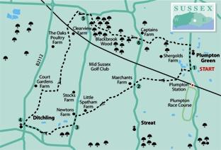
1 - Start the walk along Riddens Lane, which heads west from the village street at Plumpton Green next to the village store and post office at GR 363165. Just past the last house on the left and just short of a gate and stile, turn left over a stile and follow an enclosed path along the end of gardens to another stile.
Cross a meadow to a further stile, and follow an impressively engineered path over two footbridges to a T-junction with a track where you should turn right.
After ten yards go left across the railway and immediately go right over a stile and diagonally across a paddock, passing two more stiles. In the field corner, go over a stile, right through a gate and forward across a culvert.
You now have a choice of rights of way across a cultivated field. Yours goes more or less straight ahead where it should be marked out, though narrow, through any growing crop.
On the other side of the field, go over a stile hidden in a hedge, and half-left across rough pasture, going straight over a trodden crossing path, part of an old north-south droveway. Cross a sleeper bridge and stile next to a large house (Elmgrove Farm), go ahead along a right field-edge for 40 yards, then right over a stile and left along the drive from the house.
After 100 yards, fork half-left off the drive across a field to join a lane in the corner and turn left, ignoring the stile ahead.
2 - After 60 yards, fork right over a bridge and stile, walk ahead, parallel to a right field-edge, to a gate, on for five more yards, then left over a sturdy step-stile, one of several similar structures encountered on this walk, designed and erected by Monday Group volunteers.
Head diagonally across a field to another stile, a few yards to the left of the field corner, then half-right across a field to a stile, in sight.
Cross a track and stile, then go ahead along a left field-edge.
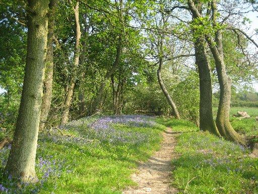
In the corner, go through a gap to another ladder stile, from which you should head diagonally across a field with an extensive view southwards to an expansive sweep of the downland ridge between the tree clump on Blackcap and Jack and Jill windmills, with the high point of Ditchling Beacon halfway between the two.
Cross another stile-and-plank bridge, go ahead for 30 yards to another bridge and on across a field to a footbridge in the next hedge. Continue diagonally across paddocks to a footbridge, then left over a stile and straight along the edge of another paddock to join Spatham Lane. Turn left.
3 - After 200 yards, just past the entrance to Stoneywish Nature Reserve, go right over a stile, cross the middle of two fields, then head half-left across a playing field and feed into a wide track which takes you out to East End Lane. Turn right and follow it out to Ditchling High Street.
Ditchling is a place to linger and explore with many old houses, a 13th-century church as well as pubs and tea rooms.
4 - To continue the walk, turn right along the High Street and, after a few yards, go right again along East Gardens which feeds into a narrow path which starts between driveways.
After about 100 yards, go right through a swing gate, forward to a similar gate next to a small stable. Now curve left across a field to a stile, head half-right across the next field, go over a stile-and-plank bridge and turn left for 60 yards to another stile.
Go ahead, passing to the left of farm buildings and on along a wide path, passing through two high gates. Just short of a sleeper causeway (not for you), turn right along a tree-lined track which may be muddy underfoot in places.
Follow it as it turns left and heads north for almost a mile, emerging to follow field edges and to pass through a disused deer enclosure, regularly punctuated by stiles and gates.
Emerging into a field, go slightly left across it, over a railway bridge and ahead across a large field, veering gradually right to join and follow the right edge until you can go over a stile. Double-back to the right to a second stile, then follow a left field-edge and a short enclosedpath out to join a road next to a junction.
5 - Cross the road and follow a path ahead within the wood edge, opposite, with a road to your left. Shortly, go right between staggered railings and follow the main path through Blackbrook Wood, ignoring all side paths and looking out for yellow arrow waymarks.
At one point, a break in the trees to the right offers a fine view of the Downs. At the far end of the wood, pass through an iron gate, go over a crossing track and two stiles, then follow a fenced headland path round the right edge to join a lane.
6 - Turn right for ten yards, then go left over a stile beside a gate and half-right across a field to the next stile, in sight. Join a drive and turn left.
After about 200 yards, where the drive bends right towards a cottage, fork left through a bridle gate (unsigned) and cross a field, skirting immediately to the left of a large barn and on beside a right-hand hedge to find a stile in the field corner.
After a short, enclosed path and two stiles, go ahead along the right edge of three fields and another short, enclosed path to join the road at Plumpton Green next to the Fountain Inn. Turn right, back to the start.
* Distance/Time: Seven miles/three and a half hours
* By Car: Start from Plumpton Green, signed northwards from the B2116 underhill road at Plumpton. Roadside parking is possible in various places along the village street. Alternatively, start from Ditchling, joining the walk at point 4
* By Public Transport: Train or bus from Lewes to Plumpton Green (Plumpton Station). Trains now hourly during the day
* What’s underfoot: Level walking along generally well-maintained and signed paths
* Thirsty Work: Pubs at Plumpton Green. Pubs and tea rooms at Ditchling, close to point 4
* So you don’t get lost: OS Explorer 122
* Find out more about the Monday Group, a volunteer organisation that maintains rights of way in the Sussex countryside, at mondaygroup.org


Comments: Our rules
We want our comments to be a lively and valuable part of our community - a place where readers can debate and engage with the most important local issues. The ability to comment on our stories is a privilege, not a right, however, and that privilege may be withdrawn if it is abused or misused.
Please report any comments that break our rules.
Read the rules here