
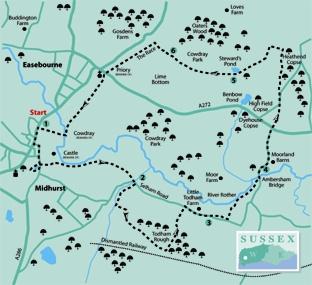
1 - From the municipal car park and bus terminus in Midhurst, walk south along the main North Street as far as Knockhundred Row and turn left, leaving the busy A272 cross-county road. In a short distance the narrow street turns right, opening out into Church Hill. Keep to the left side of the street, passing between the parish church and The Swan pub.
Cross into South Street, continuing down the roadside to the bridge that crosses the River Rother – there is a small park and South Pond across the road, to the right. Do not cross the bridge but turn left into The Wharf, following the quiet road between houses and small business units to its end. Cross right over a stone bridge and take a left branch onto a bridleway (blue arrow). Follow the tree-lined path for about a quarter of a mile and, on passing through a gate, continue between hedgerow towards the farm buildings at Kennels Dairy.
Continue between the buildings and stables, keeping to the surfaced driveway that leads to the Selham Road in 300 yards.
2 - Walk ahead for about 100 yards, crossing a bridge, and then turn right onto a rising bridleway between trees. Costers Brook is down to the right among the reed beds.
The track soon clears the trees and climbs a field beside a right hedgerow, levelling-off to enter tree cover, with a pine plantation on the left and mixed woodland to the right. In 100 yards turn left, beside the plantation, climbing across the top of the wooded hillock, then descending to a right turn and coming to a path junction in a further 100 yards. Turn left up through mixed woodland plantations, with the sandy bridleway levelling-off after 250 yards. Continue for a total of nearly half a mile (ignoring a right-turning footpath in one third of a mile) to a crossing bridleway.
Turn left along the die-straight bridleway, climbing for 300 yards to a three-way track junction. Continue ahead, going left and then right for 50 yards, and descend through Todham Rough towards the buildings and houses at Todham.
3 - Turn right along the quiet road for a quarter of a mile, passing Little Todham Farm and, at a point where the road sweeps to the right, divert left through a hedge opening and walk along a right field-edge.
In 200 yards, beside a hedge-opening and close to a prominent, solitary oak tree, turn left across the field on the footpath (at the time this walk was surveyed there was no marker post from this point), heading for the corner of a copse at the far side.
When at the copse, locate a narrow, enclosed path (there is an obscured marker post in the hedge) that goes left of a fence-line and soon skirts to the right, through the undergrowth, with the River Rother down through trees on the left.
After about 300 yards, on clearing the tree and scrub cover, cross a stile and descend a bank on the left. In the riverside paddock veer half-right, following the line of the river. Head for the far right corner of the paddock, passing through a gate onto the roadside beside Ambersham Bridge.
4 - Turn left over the bridge and in a few yards branch right, passing Moorland Barns after 200 yards and climbing to the side of the A272 road. Cross with care to the opposite public right-of-way (maroon arrow) and climb the gully path, between high banks.
On coming to a minor road continue ahead for 200 yards and, as the road branches right, turn left through a hedge opening (blue arrow) into woodland. Take the centre of three options, the less distinct, grassy path, which is the bridleway to follow through Heathend Copse. The track heads due north, following the rise and fall of the bridleway through the woodland.
After about 400 yards the track comes to more open country, with cleared woodland on the steeply rising hillside to the right. Keep to the bridleway and, on coming to a three- way path sign, turn left (yellow arrow) through a hedge-opening and walk to the corner of a field, along a right hedgeline. Turn left from the corner, skirting around tree cover and in 200 yards divert half-right (marker post) up a bank and cross a stile.
In the next field go half-left on a trodden path across the flank of a hillside, descending after 200 yards as the path takes a line between a fine, prominent lime tree and the fence surrounding Steward’s Pond.
5 - Follow the fence around to the right, climbing towards a kissing gate that is on the left. From the edge of narrow woodland turn right, beside scrub and ferns, following the wide path to the top of an incline. Pass through a copse to the edge of a golf course.
Take the path ahead across the greens, as directed by a number of footpath signs, following the undulations of the course. At the far side the path dips very slightly to the right and follows a track beneath trees. Climb out from the cover, cross a short section of grass and pass through a bridle gate.
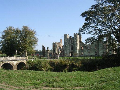
6 - Take a quarter-left line across a meadow to pass through a second gate and turn left on a tree-bordered path. Keep to the path, known as The Race, for half a mile to come to the A272 road at Easebourne. Cross with care and locate the footpath that passes the former priory buildings and continues south beside polo fields and a visitor centre for a little over half a mile to come to the ruined facade and gates of Cowdray, the remains of a Tudor nobleman’s house destroyed by fire in 1793.
Turn right over a bridge, following the causeway path back into Midhurst.
* Distance/Time: Seven miles, taking three and a half hours
* By Car: Midhurst is astride the A272 and A286 roads, car parking (fee payable) is at the north end of North Street, on the east side and adjacent to the tourist information centre. Start point GR SU887218
* By Public Transport: Travel details from www.traveline.info, phone 0871 2002233. Bus service from Chichester to Midhurst
* What’s underfoot: Wealden walking on well-defined paths, a few easily negotiated climbs, some short sections of quiet roads. Possible with a baby backpack; not possible with a baby buggy
* Thirsty Work: Plenty of pubs and teashops in Midhurst
* So you don’t get lost: OS Explorer map 133, plus a compass for general direction


Comments: Our rules
We want our comments to be a lively and valuable part of our community - a place where readers can debate and engage with the most important local issues. The ability to comment on our stories is a privilege, not a right, however, and that privilege may be withdrawn if it is abused or misused.
Please report any comments that break our rules.
Read the rules here