
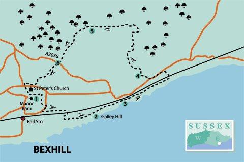
1 - Behind the Manor Barn car park are delightful gardens in which to sit, rest and admire. They are also an ideal picnic spot, either before or after the walk.
The car park is also the starting point for the 1066 Bexhill Link (see information board in the middle of the car park), part of which will be encountered later on this walk. This joins with the main 1066 Country Walk at Battle.
For this walk, exit the car park and turn right along De La Warr Road, then first right into Manor Road. At the bottom of the hill, cross to Chelsea Close and follow the pedestrian way between houses to Dorset Road. Cross here and turn right, then left into Ashdown Road, following a school playing field perimeter fence on the left.
At the end of this straight road, turn right along a path under the railway bridge, follow-ing the path until just before reaching the seafront. Here, turn left across a wide green, following parallel to the road steadily uphill to the Coast-guard Station at Galley Hill.
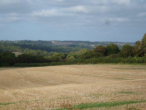
2 - Near the top of the hill there are plenty of seats on which to sit and take in the view. Close to the Coastguard Station is an information board about the Bexhill Smuggling Trail.
Continue on past the children’s play area. Please note, the next section of path is segregated for walkers and cyclists. There is a cafe at the bottom of the hill.
3 - Those with limited mobility may return from here by the same route or go under the bridge to the bus stop on the main road and return by a 99 bus (daytime, every 20 minutes; hourly on Sundays) back to Manor Barn.
Continue uphill on the Bulverhythe Coastal Link (there is another information board relating to this partway along), a new shared-use path for walkers and cyclists. From the top of the hill a distinctive blue-and-white footbridge will be seen ahead. Make for this and cross the railway line into Bridgeway and then to the main road (A259).
Turn left along the roadside path until arriving at a zebra crossing just past the Hastings Garden Centre sign on the opposite side. Cross here and double-back to go along the access road to the garden centre.
4 - At the end of this road, immediately past the car park turn right on a rough track, which is now in Combe Valley Countryside Park (previously known as Pebsham Countryside Park). This is a work-in-progress providing a managed green space between Bexhill and Hastings.
After about a quarter of a mile, turn right at guidepost 44. At the top of the hill, turn right by guidepost 45 and through an unusual green barrier. In just over 100 yards, go through a kissing-gate on the left, downhill, first round to the right, then left on to a wide grass path with a lake on the left.
This is a good spot for a rest or picnic, but stay on the path and do not venture into the lakeside flora.
Continue uphill, following a high, wire fence on the right. At the end, go through a gate, cross the Southern Water Works access road, and through another gate on to a grass path.
At the top of the hill, pass guidepost 10 on the left and, in a few paces, turn left at guidepost 8. Follow along the field edge and through a metal gate by guidepost 9. (Yes, I know it is a strange sequence!) Walk along this path under trees, through another metal gate, and along a track. On approaching farm buildings turn right, then immediately left by guidepost 11.
5 - Continue along this farm track, which is part of the 1066 Bexhill Link, with farm buildings on the left and views across fields to Crowhurst on the right. Bear left where other paths lead off to the right, then past an old cottage on the right to a junction of tracks.
Go over a stile straight ahead (marked 1066 Bexhill Link) into a field. Head diagonally across through a small clump of trees to the farther bottom corner of the field to climb another stile. Continue up the left-hand side of the field, the final part being enclosed between fences, and through a squeeze stile to cross a main road (A2036).
6 - Follow the tarmac path opposite, between garden fences and hedges. Cross an estate road (Portfield Close), continuing on the tarmac path. There is a sharp right-hand turn at the end, which leads into Lychgate Close. Turn left up the roadside path to find a path between houses (numbers 25 and 27) leading up to a footbridge over the main road.
Make for St Peter’s Church, which can be seen ahead, and cross an access road into the churchyard. Look up to see St Peter’s shield (pictured) with cross and keys sculpted in stone above the windows on approaching the building. It is also well worth looking inside this old building (if open) to see, among other things, a modern touch of very attractive banners.
Leave the churchyard by the main gate and turn left down Church Street to De La Warr Road. Cross and turn left to return to the car park, or right to return to the rail station.
- Distance/Time: Five and a half miles/two and a half hours; one and a half miles each way, to and from point 3, for those using the limited mobility option
- By Car: Manor Barn car park (free, with toilet facilities), off De La Warr Road, Bexhill Old Town
- By Public Transport: Trains to Bexhill; turn left at the station exit, walk up Upper Sea Road, bearing right at the top of the hill. Buses from Hastings, Eastbourne and Battle to Bexhill Old Town
- What’s underfoot: Mostly easy going on good paths, but some country tracks can be muddy in places, if wet. Only suitable for mobility and baby buggies as far as point 3
- Thirsty Work: Cafe on the beach at point 3, otherwise use facilities in Bexhill before or after the walk
- So you don’t get lost: OS Explorer 124 or Landranger 199


Comments: Our rules
We want our comments to be a lively and valuable part of our community - a place where readers can debate and engage with the most important local issues. The ability to comment on our stories is a privilege, not a right, however, and that privilege may be withdrawn if it is abused or misused.
Please report any comments that break our rules.
Read the rules here