
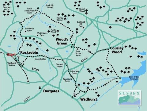
There is a choice of starting points. If arriving by road, start at the Parish Church (point 3). There is also an optional extra by Bewl Water and a long section of the Sussex Border Path
1 - If arriving by train, bear right from the station exit and go through the car park to the road. Cross to the footway opposite and turn right.
In around 150 yards, turn left up a driveway. At the top, bear right in front of houses. (If starting from the village, continue from here.)
2 - Immediately past the houses on the left, turn left sharply along a track towards large wooden gates. Go through a small gate on the right, then right along a hard track between fences.
On coming to a gate, go over a stile on the right. In a few paces, where the track bends to the left, go up steps on the right and along a narrow footpath to the road.
Turn right along Three Oaks Lane for nearly half-a-mile, then fork left, past Stone Bridge Cottage on the right. Nearing the top of the hill, turn right on a field edge footpath, then cross a stile and across fields to a road.
Turn right along Turners Green Road and go straight over the crossroads. At Primmers Green, cross a major road, continuing to the bottom of the hill and then bearing right along Blacksmith’s Lane to go uphill again.
Nearing the top of the hill, go up steps on the right and along an enclosed footpath. This leads through a gate into the churchyard.
3 - The Parish Church of St Peter and St Paul is an alternative starting point in the village, if arriving by road. If starting here, it will be necessary to walk the section between points 2 and 3 at the end.
There has been a Christian community in Wadhurst for many centuries, and parts of the present church building are nearly a thousand years old. Take a look inside – it is usually open during the daytime.
Facing the church’s main entrance, follow the path to the right alongside a wall. Go through a kissing-gate, along an enclosed footpath to the road and turn right along Blacksmith’s Lane again.
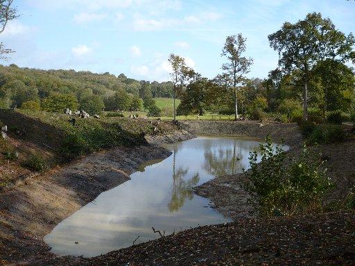
As the road bends right, turn left along a rough track past Little Pell Farm. Continue over a stile on the left, keeping on the track which goes downhill and past a new pond on the left.
Where the track ends, follow a footpath through woodland to cross a stile into a field. Continue ahead to go over another stile into woodland.
In a few paces, turn left onto a bridleway which is the Bewl Water perimeter path. After about 100 yards turn left on a grass footpath.
4 - However, if desiring to go to the water’s edge, continue on the bridleway to find a good spot for a picnic or photographing wildfowl. Then retrace route to the grass footpath.
The route now follows the Sussex Border Path (look for the letters SBP on posts). Turn right over a stile into a field going uphill with a hedge and wood on the left.
On reaching higher ground there are good views across the reservoir. Go through a gap, then diagonally left with a field ditch on the left.
Bear right at the top of the field and continue ahead along a hard track to the main road at Cousley Wood. Turn left here, to pass (or drop-in, if desired) the Old Vine pub.
Follow the roadside footpath, and just beyond a road junction (signposted to Hook Green) at the end of a wooden fence on the right, cross the road. Go through a gate and ahead on a wide grass path.
Continue along field edges and then downhill to a gravel drive by houses to a road. Turn right, then turn left at the next junction.
5 - This is Wood’s Green and there is a green on the left if a rest or picnic is desired at this point. Continue past the green and turn right into Wyck Lane, going downhill.
At the top of the first rise, bear right then downhill again to the end of the lane. Turn right through a gate into a field then left along a field edge. Where the hedge veers to the left, follow the fence on the right and continue along field edges and over a stile.
Cross a field, through a gap, then downhill towards a farm which can be seen between trees on the farther hillside. Go through a gate at the bottom of the field, straight ahead through a small gate, then uphill to cross a new stile by Great Shoesmiths Farm.
6 - Turn left along the driveway bearing right at a bend and continue until coming to a narrow minor road. Turn left downhill, then uphill to where the road turns a sharp left.
Go straight ahead on a bridleway between fences, continuing for about three-quarters-of-a-mile to cross a substantial bridge. On coming to a road (Three Oaks Lane), turn right uphill.
Where the road bears right, turn left on the bridleway to go past Rock Robin Cottages. Go through a gate marked Spike Island into a garden.
Follow the overhead power lines to the right of the house; guide posts confirm that this is a right-of-way and leave through another gate. This leads to a driveway with houses on the left.
To return to the rail station, turn right and retrace route at the beginning. To return to Wadhurst village, continue the walk from point 2.
- Distance/time: Seven miles/three-and-a-half hours; allow extra if going along by Bewl Water
- By Car: Public car park (free but avoid busy times) behind the Greyhound Inn off B2099. Cross the road to the Parish Church
- By Public transport: Trains to Wadhurst; buses to the Greyhound Inn at Wadhurst
- What’s Underfoot: Typical undulating Wealden paths and roads. Expect some mud, in places, on field and woodland paths
- Thirsty work: Greyhound Inn at Wadhurst; Old Vine pub at Cousley Wood
- So you don’t get lost: OS Explorer 136
Click here for a full-sized map of the Wadhurst circular walk


Comments: Our rules
We want our comments to be a lively and valuable part of our community - a place where readers can debate and engage with the most important local issues. The ability to comment on our stories is a privilege, not a right, however, and that privilege may be withdrawn if it is abused or misused.
Please report any comments that break our rules.
Read the rules here