
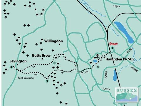
1 - If arriving by train, from the station exit turn left into the main road (Brassey Avenue). In about 120 yards, turn left at the Post Office into Rosebery Avenue for about 400 yards and, at a triangle junction, bear left along Hampden Park Drive. The Lakeside Tea Chalet will be found on the left after about 500 yards, on the south-east side of the lake (inset).
This is a good spot for a picnic or rest either before, or after, the walk. Also, take the opportunity to observe and photograph the wildfowl on and around the lake.
2 - Facing the Lakeside Tea Chalet, go along the footway to the right and, where the road bears sharply right, continue straight ahead along Park Avenue, past the recreation ground on the left, to the busy main road (King’s Drive/A2021). Cross at the traffic lights and go up the continuation of Park Avenue opposite.
On the way, cross to the right-hand footway and go past Ratton School to the top of the road. Cross the busy Willingdon Road (A2270) at the traffic lights and turn right along the footway.
After just over 200 yards turn left up a bridleway (signposted Willingdon Hill and Jevington). Once past houses on the left there is a golf course, also on the left. On coming to a brick wall turn right and, in a few paces, come to an estate road.
Turn left here, uphill, passing a few houses, and then turn left uphill on the continuation of the bridleway (again signposted Willingdon Hill and Jevington). This now climbs steeply, at first through woodland. Keep straight ahead, ignoring all side paths.
The way which began in a generally westerly direction now veers around to the south-west. Soon after coming into the open there are extensive views on the left over Eastbourne and the countryside beyond. Unfortunately there are no seats here, apart from a grassy bank.
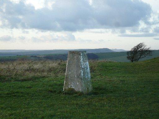
On nearly reaching the top of the hill, at crossways, aim for the concrete pillar which can be seen to the right. This is an Ordnance Survey triangulation station, commonly known as a trig point. These were erected during the first half of the 20th century to form a network of fixed points used for map surveys, before the days of aerial and satellite surveying.
3 - Keeping this direction (north-west), the distinctive whale-back shape of Firle Beacon can be seen in the distance. This is now part of the South Downs Way, a national trail bridleway from Eastbourne to Winchester. Look for the acorn signs on posts.
In about 100 yards come to a post inscribed “Jevington: 1 mile” and continue on this bridleway going downhill. The path nearer to the fence on the left may make for easier walking until it becomes overgrown, when it will be necessary to revert to the main track.
The bridleway narrows as it descends to the road. Now in Jevington Lane, turn right with care along this narrow road and then left into Church Lane (continuation of the South Downs Way) to head for the ancient parish church (open every day from 9am to 5pm). This is a good spot with seats to sit for a rest or a picnic.
The Eight Bells pub is a little farther along Jevington Lane on the left, or can be reached from the northern exit of the churchyard. This is a much safer route as there is a roadside path from this point to the pub.
4 - Return southwards along Jevington Lane and in a few paces past Church Lane, immediately past what was the Hungry Monk Restaurant (now closed), turn left into Willingdon Lane. Immediately past houses, go through a gate and follow the bridleway straight ahead through the valley.
This gradually bears left and through a piece of woodland to go through a gate. The gates on this section are easily operated as this is a bridleway. The route at this stage is still fairly level.
After passing through a gate with an Access Land symbol, the gradient becomes much steeper. Finally, the way levels to go through a gate into the car park at Butts Brow. There is an information board ahead and slightly to the right.
5 - There are several routes down the eastern escarpment; however, these are very steep and can be very slippery, especially if wet. The safest way down at this time of year is to follow the access road on the left, facing any oncoming traffic up the hill.
After nearly half a mile, just before a sharp right-hand bend, turn right by a metal barrier along a fairly level grass footpath for about 200 yards. On approaching a junction, turn left down a few earth steps and along a narrow path by a board fence.
Where this emerges on to a road (Melvill Lane), turn right downhill to a triangle junction with a small green and bear left into Parkway. Follow this to join Wish Hill, just before reaching Willingdon Road (A2270).
Here, turn right along the footway, passing the beginning of the first bridleway on the outward route. At the next major road junction, cross at the traffic lights into Park Avenue and retrace the route back to Hampden Park and the Lakeside Tea Chalet or back to the rail station.
- Distance/Time: Six miles/three hours; allow an extra 15 minutes each way if coming by train; also for visiting the Parish Church and/or pub in Jevington.
- By Car: Roadside parking in Hampden Park approached from Decoy Drive or Rosebery Avenue, into Hampden Park Drive; or from King’s Drive into Park Avenue (east).
- By Public Transport: Trains to Hampden Park – frequent service from Lewes, Eastbourne and Hastings.
- What’s underfoot: Some urban footways but also some steep and slippery places on the Downs, especially when wet.
- Thirsty Work: Lakeside Tea Chalet with toilets at the rear (start/finish) or The Eight Bells pub in Jevington.
- So you don’t get lost: OS Explorer 123 or Landranger 199. A compass would be useful for general direction.
Click here for a full-sized map of the Hampden Park to Jevington walk


Comments: Our rules
We want our comments to be a lively and valuable part of our community - a place where readers can debate and engage with the most important local issues. The ability to comment on our stories is a privilege, not a right, however, and that privilege may be withdrawn if it is abused or misused.
Please report any comments that break our rules.
Read the rules here