

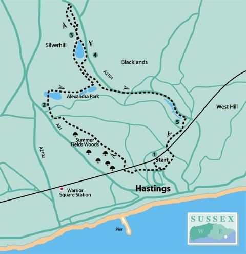
1 - From Hastings rail station, go to the main road and turn right at the traffic lights. Go downhill and then uphill through Cornwallis Terrace, and cross into Cornwallis Gardens. Continue uphill, crossing Linton Road into Holmesdale Gardens.
At the top of the hill turn right between houses by an informative Greenway sign. Follow this footpath, bearing right downhill over the railway tunnel, then bear left to go uphill alongside Summerfields Woods on the left.
This is a Local Nature Reserve (LNR) with numerous accessible paths through the woods which contain two ponds, an ice house, a walled garden and a mock Roman bath. However, it may be better to keep to the hard surface path at this time of year.
Continue beyond the top entrance to the nature reserve, past a telecommunications mast and school on the right, and Horntye Park Sports Complex on the left. Emerge into Horntye Road by the school entrance and go to the bottom of the road.
Turn left along Newgate Road and right into Clarence Road. Then cross Upper Park Road to one of the main gateways to Alexandra Park on the right, where an information board advises that this linear park extends to 109 acres and was opened by the Prince and Princess of Wales in 1882.
2 - Do not enter the park through the main gateway but go past Bohemia Lodge, adjacent, and immediately turn right to follow the tarmac path downhill and over a wide bridge. Turn right alongside Shornden Reservoir and observe the wildfowl enjoying the water.
At the end of the reservoir, continue straight ahead into woodland and pass by Harmer’s Reservoirs (no relation to this writer!) on the right. On coming to a T-junction, where there is a greenway sign indicating Buckshole Reservoir, turn left along this public footpath.
Squirrels abound here, and on the lower paths encountered later, so have a camera handy. It is possible to get quite close, if approached slowly.
After about a quarter of a mile, bear right off the main footpath but keeping to the left of the reservoir which is just coming into view. On reaching Vale Road turn right, which soon leads into a bridleway (see green sign on fence) running alongside the reservoir.
3 - If going into the nature reserve, continue straight ahead and, on reaching the Old Roar Gill & Coronation Wood LNR sign board, take the left-hand path. In a short distance go over a footbridge and follow the stream on the right.
On reaching a road bridge with stone pillars towering above, go across the footbridge and turn right by a fence on a path leading back under the road bridge. Follow the high level path through the wood and, on sight of a house on the left, bear left to a metalled bridleway. Turn right downhill to pass the LNR sign again to-wards the Buckshole Reservoir.
Whether or not going to the Nature Reserve, follow around the northern end of the reservoir. Near the southern dam end is a viewing platform from which to observe the wildfowl.
4 - Continue ahead downhill and, by steps leading from the road, bear right downhill and look for a plaque at ground level on the left indicating Dr McCabes Well. This is another area where squirrels abound.
Then head towards and over a bridge with green railings and turn left. At the next junction of paths, bear right to pass a miniature railway track (left) and a house (right). Just beyond there is a toilet block (if required) on the left, but bear right towards a guide post.
Here, turn left, and bear left again over a metal bridge with green railings to go past the Peace Garden on the right. There are plenty of seats in this vicinity if a rest is desired. The path then continues past tennis courts on the right to come to a road (Dordrecht Way).
Cross to continue in the park directly opposite. The path goes downhill past a large grass area used for recreational activities. There are more seats here if a rest is desired.
Go straight ahead to pass the Rangers office and more toilets on the left. A cafe and bandstand will be seen on the right. Follow along the path with a stream on the right until going over a metal bridge to continue by the stream, which will now be on the left.
Bear to the left of a lake (with a viewing platform on the right) and go past a bowling green, and then past yet another toilet block. Continue past another lake with a special feature in the water which wildfowl make good use of as a perch, and head for the war memorial seen to the right.
5 - Facing the memorial, go to the left and up the steps to leave the park. For those with limited mobility or baby buggies, exit the park by the main gateway in the corner to the left and turn right along the roadside path.
Cross the road at the zebra crossing and turn right to go up Braybrooke Road. Cross at the traffic lights and turn left down South Terrace over the railway bridge. Turn next right into Devonshire Road to go past Sainsbury’s Local on the right. Then turn right at the main traffic lights to return to the rail station.
- Distance/Time: Four and a half miles/two hours; three and three quarter miles/one and a half hours if not venturing into the nature reserves
- By Car: Ample parking (charges apply) in Hastings town centre. Alternatively, use free roadside parking in Upper Park Road or Clarence Road and start from point 2
- By Public Transport: Trains to Hastings (frequent service on both Coastway and Charing Cross lines)
- What’s underfoot: Mainly urban footways with a few steep and slippery places, especially when wet. It may be possible with a baby buggy if not venturing into the nature reserves
- Thirsty Work: Cafe in Alexandra Park or pubs and restaurants in the town
- So you don’t get lost: OS Explorer 124 or Landranger 199


Comments: Our rules
We want our comments to be a lively and valuable part of our community - a place where readers can debate and engage with the most important local issues. The ability to comment on our stories is a privilege, not a right, however, and that privilege may be withdrawn if it is abused or misused.
Please report any comments that break our rules.
Read the rules here