

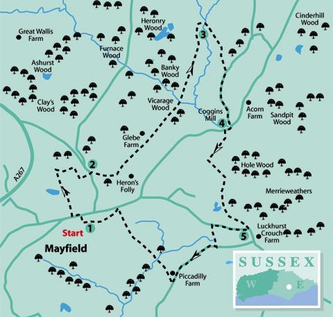
1 - Before leaving the car park, look south for a good view (on a clear day) of the upper Rother Valley to the ridge at Broad Oak between Heathfield and Burwash Common. Leave the car park, turn left along South Street and in a few paces turn right into Star Lane (pedestrians only). Go uphill into the High Street opposite the Parish Church.
If arriving by bus, alight near the top of the High Street. The Parish Church is on the north side. If you want to look inside, go up the steps or around the church building.
Otherwise, go along the footpath adjacent to the left-hand side of the churchyard wall. Continue past a pond on the left, then immediately past a pond on the right and, before a stile, turn a sharp right.
Follow the path alongside tennis courts on the right and at the end of the fenced area turn right. On coming to an access road, turn left to reach and cross the main road.
2 - Almost opposite, and slightly to the left, is a track which is a public right of way. Follow this for 250 yards and just before a white gate, go over a stile on the left.
Continue along the field-edge path to the right, past a property known as Heron’s Folly and over a stile into the next field. On coming to a crossway of paths, where there is a finger post, continue straight ahead, with a hedge on the right, to the bottom of the field. Glebe Farm will be seen to the left.
Go over three more stiles in succession then enter Vicarage Wood, continuing on the footpath going downhill. Just past a marker post, proceed with great care down a steep slope to go over a footbridge.
Bearing right, go over a stile, then go up the left-hand edge of the field, adjacent to a wood. Passing a tree with a yellow marker, go straight ahead across the middle of the field, through a gap and across the next field to the corner of a small wood.
3 - Looking over a stile, there may still be evidence of a colourful tradition enacted at the spring equinox at the site of a Clootie well. These wells, mostly found in Scotland or Ireland, are associated with an old Celtic custom and paganism, and characterised by the hanging of colourful strips of cloth or rags from the branches of trees, known as wish trees, near the wells which are places of pilgrimage reputedly bestowed with magical healing powers.
Although you will see this walk continue across a deep gulley in the wood, take the easier route along the field edge by the wood until coming to another stile. Cross this and turn back into the wood, but on the other side of the gulley.
On coming to a footbridge, cross and take the right-hand path to come to a stile leading on to a track. After about 400 yards, come to Pennybridge Lane and turn right, going downhill for about 500 yards to Coggins Mill.
4 - This settlement, associated with Mayfield, dates back to when water was used to power both agriculture and industry. This was more readily available here than on higher ground in the village.
Turn right along Coggins Mill Lane, over the river bridge and around a sharp right-hand bend. (Watch out for oncoming traffic!) Look for a footpath on the left indicated by a finger post. Follow this path downhill, over a stream, then uphill between temporary fencing. Ignoring a stile and footpath on the right, continue straight on to cross a stile into another field.
Turn left and follow the field edge uphill to cross another stile. Turn right to come to a crossway of paths at the top of the hill. Cross a stile and then continue straight ahead, downhill past a pond in the wood on the right. Follow the path uphill again to the top right-hand corner of the field, over a stile and out to the road (East Street).
5 - Turn right for about 300 yards. Just past the houses on the right, cross to a footpath on the left. It leads between fences, downhill then up again to Piccadilly Lane.
Turn right, go about 500 yards past Piccadilly Farm on the right and then turn right to go over a stile on a marked footpath. From here, Mayfield village and its church spire is seen across the valley. Take the right-hand path, with a fenced area on the left, to go downhill and over a footbridge.
Continue up the left-hand edge of two fields, crossing two more stiles; then bear slightly right to cross a narrow plank bridge. Follow the path up the left-hand edge of the next field, over another stile and along a short track to a road junction.
If returning to the car park, turn immediately left along The Avenue then go about 250 yards. If wishing to return to the High Street, cross the road junction to Fletching Street and turn left. This leads past the Primary School at the top of the hill into the High Street.
There are several places of interest in this centuries-old village; so, if time permits, take a look around before leaving.
- Distance/Time: Four-and-a-half miles/two-and-a- quarter hours
- By Car: Car park (free) with toilets, off South Street, Mayfield, signposted down a narrow one-way street near the top of the High Street
- By Public Transport: Buses (251/252) to Mayfield from Heathfield and Tunbridge Wells. Timetable information from Traveline: 0871 2002233 or www.traveline.info
- What’s underfoot: Mostly field and woodland paths, which are likely to be muddy, if wet, and quite a lot of stiles
- Thirsty Work: The Middle House pub in the High Street and Carpenters Arms and Rose And Crown pubs in Fletching Street (all near the start/finish)
- So you don’t get lost: OS Explorer 136 or Landranger 199 and a compass for general direction
Click here for a full-sized map of the Mayfield circular walk


Comments: Our rules
We want our comments to be a lively and valuable part of our community - a place where readers can debate and engage with the most important local issues. The ability to comment on our stories is a privilege, not a right, however, and that privilege may be withdrawn if it is abused or misused.
Please report any comments that break our rules.
Read the rules here