
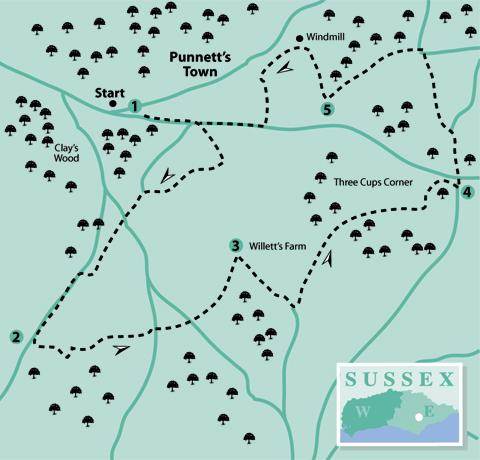
1 - Looking south from the car park, admire the view across the Low Weald. Now turn and, facing the primary school, turn right along the roadside path, past Barley Mow Lane on the right and the Barley Mow pub (apparently closed).
Then turn right down a minor road with the unusual name of Flitterbrook Lane for 250 yards. At the road junction, turn right along a byway which has a good hard surface for its whole length. Where it meets Barley Mow Lane, turn left.
At a crossroads, go straight over into Gibbons Lane. Continue along this road, ignoring footpaths on the left, following it around to the right and then turn left at the T-junction.
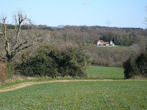
This is a wider road with the likelihood of more traffic but there is a grass verge on the right. Views to the right include Old Heathfield Church and, on the horizon, the Heathfield TV mast.
2 - After 500 yards turn left, opposite a circular mirror, on a signed footpath towards White Birch Farm. At the end of the track, go through a metal gate and down the field edge.
On coming to a finger post, turn left along the field edge, then right at the next finger post to go down the right-hand field edge. At the bottom, enter a wood by a footpath marker and bear left to cross a footbridge.
Follow the steep path out of the wood and go up the right-hand field edge to the road. Turn left, and in 50 yards, turn right by a footpath plinth, aiming for a finger post along the left-hand field edge.
Continue in the direction of the arrow through into a paddock. Go to the farther right-hand corner alongside a garden and down the drive to cross the road.
Go up the bank opposite by a footpath plinth and follow the path across the field which descends into a wood. Cross a footbridge and go up out of the wood, into a field and towards a metal gate.
Here, turn left along the top of the field and over a stile. The route now leads up a track to the top of the hill. Ignore the stile and footpath on the left and bear right to a road (Flitterbrook Lane again).
3 - Turn right, going downhill for a quarter-of-a-mile to go over a stream at the bottom. Then, in a few paces, turn left over a stile and go forward along a clear track. Continue through an open gateway with an overgrown redundant stile on the left; then up the left-hand side of a field with woodland on the left.
On coming to a finger post at a crossway of paths, go forward into the wood. In a few paces, at a divide, take the right-hand path. This leads steadily uphill with a steeply-sided ghyll (a wooded ravine) on the left.
When reaching a stile, go over and continue along the left-hand field edge. Where this bears around to the left, continue straight ahead and go over a stile into another field.
Follow along the left-hand edge to a finger post and then go through a gate on the left. Continue along the right-hand field edge and over a stile, then cross the next field and over another stile.
Follow the footpath as it twists and turns through woodland. If in doubt, the direction is north-east veering around to east. This will lead to a road by a sign on the right indicating Turner’s Green. Cross the road and turn left to go past a post box and telephone kiosk, both in traditional Post Office red.
4 - This is Three Cups Corner with the Three Cups Inn around the corner on the right. Either without calling in, or afterwards, cross the main road with care to a bridleway directly opposite the junction.
Follow this for 200 yards and where the way divides, bear left. In a few paces, turn left over a stile. Bear right down the field to go over a stile by a gate at the bottom; aligning with the left-hand side of farm buildings which will be seen on the farther hillside.
Continue up the left-hand side of the field, over a stile, and alongside Geldridge Farm. Emerge onto a bridleway, known as Forest Lane, and turn left. Follow this lane for about 650 yards until coming to a crossroads.
If not going to the windmill, continue straight over the crossroads for a further 350 yards and, ignoring North Street on the right, turn right along the main roadside path; returning to the school and the car park opposite.
5 - Otherwise, turn right to go up Blackdown Road. Around the corner at the top will be seen a less-than-complete smock windmill which was moved from Biddenden in Kent to its present position in 1859.
There is a public footpath through the white gate which leads to the right of the mill for a closer look, but for a better view, go along the road and turn around at the next gate. This is the highest point of the walk and there are good views to the north from here.
To continue the walk, go down Mill Lane, heading south-west, and bear left at the next junction into North Street. At the bottom, turn right along the main roadside path; returning to the school and the car park opposite.
Distance/Time: Five miles/two-and-a-half hours; an extra quarter of a mile for the windmill visit
By Car: Car park (free) off B2096 in Punnetts Town, entrance opposite signpost for Village Hall and Medical Centre
By Public Transport: Buses (355) infrequent service between Heathfield and Battle (none on Sundays); alight at Punnetts Town Primary School. Timetable information from Traveline: 0871 2002233 or www.traveline.info
What’s underfoot: Some quiet roads; also field and woodland paths, and tracks, which are likely to be muddy in places, if there has been recent rain
Thirsty Work: The Three Cups Inn (point 4)
So you don’t get lost: OS Explorer Map 123 or 124; also a compass for general direction


Comments: Our rules
We want our comments to be a lively and valuable part of our community - a place where readers can debate and engage with the most important local issues. The ability to comment on our stories is a privilege, not a right, however, and that privilege may be withdrawn if it is abused or misused.
Please report any comments that break our rules.
Read the rules hereLast Updated:
Report this comment Cancel