
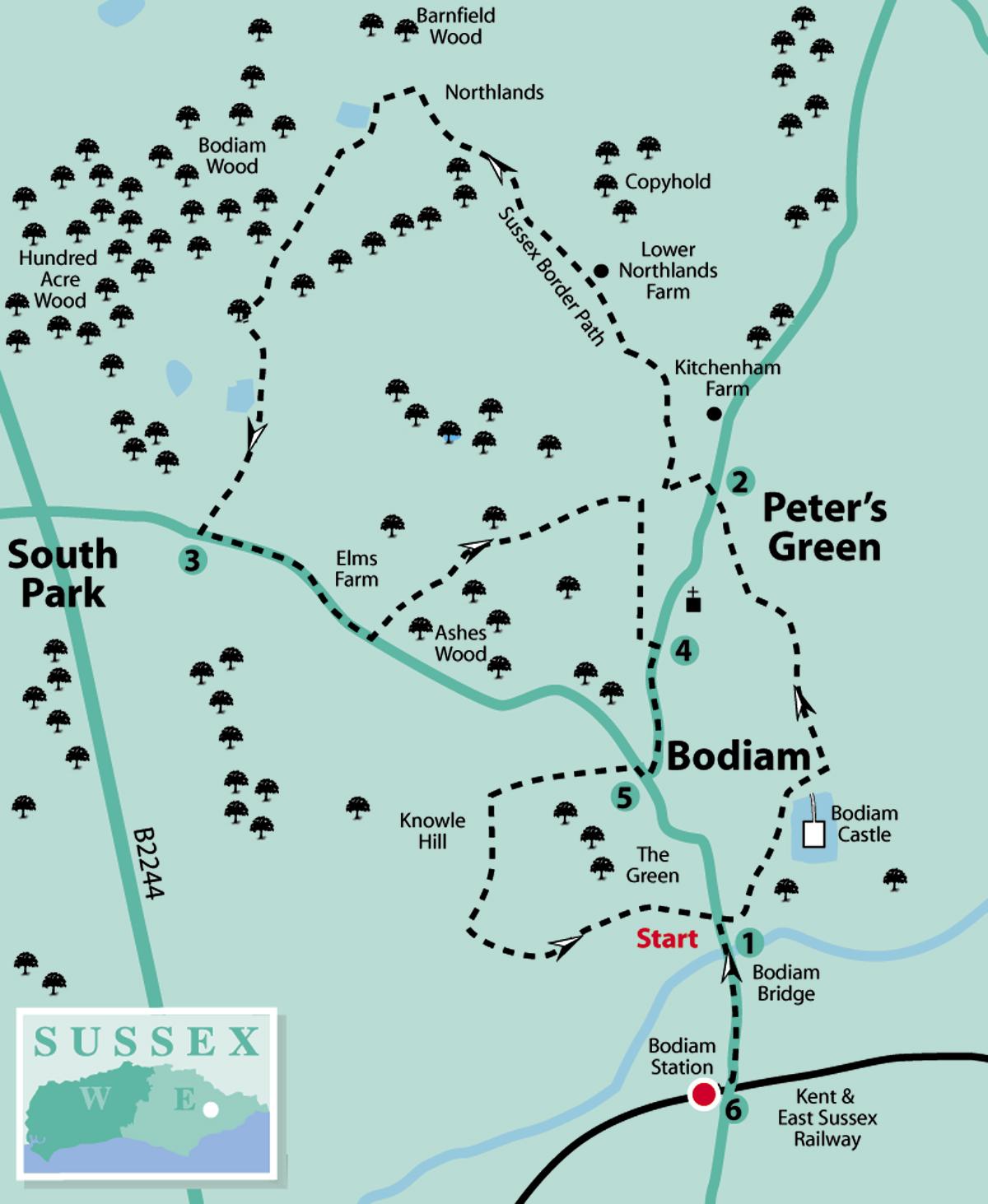
1 - From the entrance to Bodiam Castle car park, keep to the left and follow the footpath, part of the Sussex Border Path, towards the castle. This 14th-century moated fort, with picturesque exterior but ruined interior, often hosts historical events, so don’t be surprised to see people dressed in costumes of a bygone era.
Go to the left of the moat and past the ticket office (unless visiting the castle before continuing the walk) with the castle entrance on the right.
Keep left across the grass, aiming for the left-hand corner to go over a stile. Follow the path steadily uphill alongside a fence.
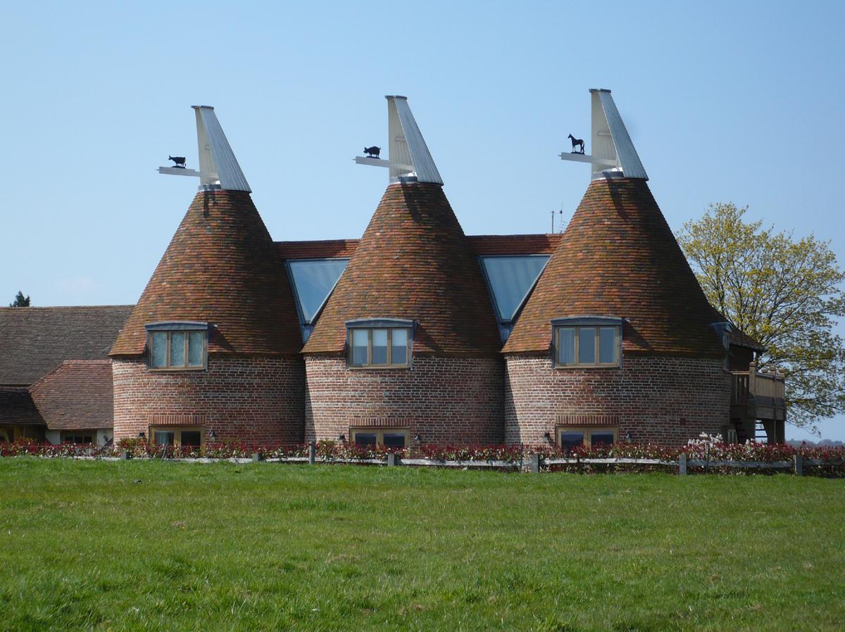
Look to the left near the top of the hill to see a triple oast house or hop kiln (now a dwelling) with a cow, pig and horse on the white cowls – presumably the work of a traditional blacksmith.
Where the fence ends, bear half-left to cross two converging tracks to go over a stile. Continue downhill to a fingerpost, turn left and over a stile then, in a short distance, over another stile on the right into a field. Go downhill, aiming for a fingerpost between two white houses. Emerge on to a road and turn right.
2 - In a few paces, turn left along a farm drive and follow around a sharp right-hand bend, ignoring a footpath on the left. A little way along, a hop field will be seen on the right, one of the few remaining in an area where there were many in years gone by. More about hops later.
Continue on to Lower Northlands Farm, through a metal gate by a fingerpost and straight on to follow what has become a grass track. In 400 yards, go over a stile on to a woodland path for a short distance. Emerging into a field, continue with the wood on the left and then straight ahead towards a fingerpost at the top of the hill.
At this T-junction, turn left along a track, past a large farm building (left). Follow the track which bears around to the left, then right, past a pond (right) and on past Northlands House. Continue along the track for half a mile, ignoring all turn-offs, until coming to a road.
3 - Cross and turn left along this often busy road with care for a quarter of a mile. Just past Elms Farm on the left, turn left by a footpath plinth.
[At this point, if desiring a shorter option omitting an often very muddy path and a steep climb, it is possible to continue along the road for another half-mile to pick-up the walk again at point 5.] Continue over a stile, through a gate, and then over another stile into a field. Bear slightly right to go over a stile to pass through woodland. On coming to a gate, go along the left-hand edge of the field ahead, then through the next gate straight ahead downhill to a fingerpost at a crossway of paths at the bottom of the field.
Here, turn right to go through a metal gate ahead, then bear half-right up a steep hill aiming for a stile between houses at the top. This leads along a twitten to cross an estate road.
The path continues up a bank by a fingerpost into a wooded area. Bear slightly to the right and emerge into Levetts Lane by another fingerpost, just to the right of a red telephone kiosk and post box. Turn left along the footway to a road junction.
4 - Directly opposite is the entrance to Bodiam Parish Church, dedicated to St Giles. Hidden away in a wooded glade, this historic building has records going back to the 13th century. A notable feature is its collection of medieval brasses, so take a look inside, if open.
Continue the walk by turning right from Levetts Lane or left from the church entrance, heading south. Go past a school entrance and on to a road junction. Turn right, and in a few paces, turn left on to a footpath.
5 - [If having taken the shorter option along the road from point 3, turn right here.] Go over a stile and along a wide grass track. Pass by a brick building on the left and bear slightly left across a yard, with houses on the left. Go through a gate, leading to a track and turn left.
Continue through another gate, downhill, and at the bottom turn left along another track. Follow this for about 700 yards, passing The Old Cricket Pavilion (now a dwelling) until coming to the village green on the left and the Castle Inn on the right. [The walk can be ended here, if not visiting the preserved light railway.]
At the road, turn right across Bodiam Bridge over the River Rother. Continue along the roadside path for 300 yards to Bodiam Station (actually in Ewhurst Parish) which is on the Kent & East Sussex Railway.
6 - In its heyday, this line was used to bring hop-pickers from London. It was regarded as a holiday with pay by the hoppers, who brought most of their belongings with them to stay in hoppers’ huts, an example of which can be seen here.
Steam trains still run on this line. Leaflets are available at the station offering walk and ride trails in the beautiful High Weald. After the visit and/or ride, retrace the route to the lay-by or Castle car park.
Distance/Time: Five miles/two and a half hours; shorter options available.
By Car: Bodiam Castle car park (free to National Trust members), which is to the south of the village, or use the lay-by 100 yards to the south over Bodiam Bridge.
By Public Transport: Bus no 349 offers a limited service to Bodiam Castle from Hastings and Hawkhurst. Timetable information from Traveline: 0871 200 2233 or www.traveline.info
What’s underfoot: Mainly field and woodland paths and tracks, which may be muddy in places, if there has been rain.
Thirsty Work: The Castle Inn (opposite Bodiam Castle car park entrance) or Castle Tearoom (adjacent to car park).
So you don’t get lost: OS Explorer 136 or Landranger 199; also a compass for general direction.


Comments: Our rules
We want our comments to be a lively and valuable part of our community - a place where readers can debate and engage with the most important local issues. The ability to comment on our stories is a privilege, not a right, however, and that privilege may be withdrawn if it is abused or misused.
Please report any comments that break our rules.
Read the rules here