
1 - If arriving by bus, walk along Church Lane. Once past a few houses, continue on a path on the left, running parallel with the road. In about 300 yards emerge opposite the entrance to Guestling parish churchyard.
If arriving by car, park with care off-road near the church.
Enter the churchyard through the lychgate. These roofed gates at the entrance to many churchyards were used during funerals as a temporary shelter for the coffin; note the central resting place with a plaque.
The church building, dedicated to St Laurence, is believed to date back to Saxon times, but the tower supporting the rather squat spire would have been added after the Norman Conquest. It is usually open during the daytime, so take a look inside.
Follow the path to the bottom (east end) of the churchyard and through the gate. Note the waymark indicating this is part of the 1066 Country Walk – Hastings Link. This is an off-shoot of the main route from Pevensey to Rye, featured in one of my recent walks.
Bear right across the field to go through a small metal gate. Pass to the left of a small wood with a pond and follow the path to the bottom of the field to go through a kissing-gate into Guestling Wood.
Once over the stream, bear right to follow the waymarks. Then, in 300 yards, bear right again to continue on the 1066 link path. Follow this for a further 250 yards to go through a gate. Go along the right-hand field edge and through three gates in succession.
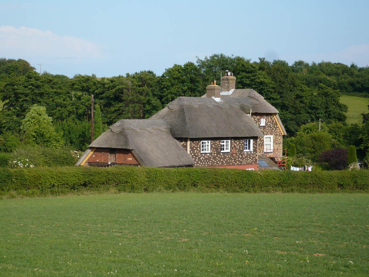
Turn right along the field edge, then under trees and through a gate. Bear left along a driveway and, where this bears left, go straight ahead along the footpath enclosed between fences. In a very short distance, go through a gate to a minor road. Notice the thatched cottage to the right.
2 - Cross the road to go through another gate into Glebe Wood. There are three paths leading from here so be careful to keep to the left, following as closely as possible to the left-hand edge of the wood.
Continue until emerging on to a minor road and turn left uphill. In a few paces cross Pett Road with great care (limited visibility) to find a footpath directly opposite by the side of a Friars Hill sign. Here we leave the 1066 link, which heads off towards Hastings Country Park.
Follow the footpath downhill over a stile, then down the right-hand field edge and over a footbridge, continuing uphill by the side of a wood. About 50 yards beyond this, turn left over a double stile with a deep drop.
Go straight ahead down across the field and over a stile to cross a minor road (Peter James Lane) and a farm track. Go over the next stile and follow the footpath along the left-hand field edge and woodland on the left to cross another stile to another minor road (Rosemary Lane).
3 - Turn right for 220 yards. Shortly after crossing a stream with the delightful name of Marsham Sewer, look for a fingerpost and stile hidden in the left-hand roadside hedgerow.
Go into the field and bear diagonally right uphill, over a stile and straight ahead to the top of the hill. From here, on a clear day, it is possible to see Dungeness Power Station.
Now bear left to cross a stile in the converging left-hand hedge. Turn right downhill alongside the right-hand field edge and over a footbridge.
Continue straight ahead for about 60 yards, then bear left uphill for another 250 yards. Ignore another footpath which goes off to the right and climb a stile to continue ascending the hill.
On nearing the top of the hill, with the spire of Pett church in view, slightly to the left, enter the churchyard. Go straight ahead through a small wooden gate and look for, but do not disturb, the small mouse climbing one of the upright bars.
Turn left to see the church building dedicated to St Mary and St Peter, which is quite new for a parish church, having been built in 1864. Notice the distinctive spire atop an octagonal tower.
4 - From the main entrance, cross the road and up a few steps to go along a footpath between houses. Go over a stile and bear slightly left downhill over another stile into the next field.
At the bottom, cross a stile and continue on the footpath straight ahead alongside woodland. Follow the footpath as it heads generally north-west through the wood, crossing a footbridge over a stream.
On leaving the wood, go uphill across a field to the corner of a wood, then straight ahead, keeping fairly close to the right-hand field edge to go through a gate on to a farm track.
Turn left and, at the minor road, turn left uphill. At the sharp bend, turn right through a gate and into Guestling Wood.
5 - Follow the path in a westerly direction and, in 175 yards, cross a wide path. Continue now in a south-westerly direction downhill to cross a culvert with stone supports indicating an ancient crossing of the stream.
Go out of the wood through a wide gate, uphill across the field, through another gate and turn left along a wide track. In 125 yards, bear right back into Guestling churchyard.
For bus users retrace the route to the main road.
- Distance/Time: Four and a quarter miles/two and a quarter hours; an extra half mile for bus users.
- By Car: Park off-road near Guestling parish church, off A259 (east), a quarter of a mile along Church Lane. (There is a church car park but a sign indicates that it is private).
- By Public Transport: Buses (100) from Hastings and Rye to Guestling, alight at Church Lane, quarter of a mile north of the primary school at Guestling Green. Timetable information from Traveline: 0871 200 2233 or www.traveline.info
- What’s underfoot: Mostly good field and woodland paths; also short distances on minor roads. Quite a lot of stiles and a couple of short steep climbs.
- Thirsty Work: The Royal Oak and Two Sawyers pubs, Pett, just off-route from the parish church.
- So you don’t get lost: OS Explorer 124 and Landranger 199; also a compass for general direction.
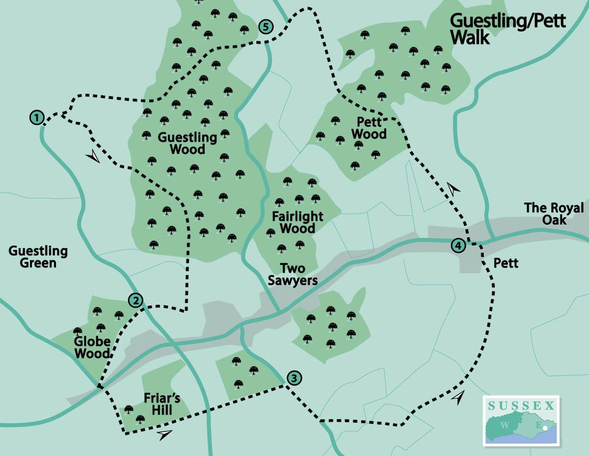
Click here for a full-sized map of the Guestling/Pett circular walk


Comments: Our rules
We want our comments to be a lively and valuable part of our community - a place where readers can debate and engage with the most important local issues. The ability to comment on our stories is a privilege, not a right, however, and that privilege may be withdrawn if it is abused or misused.
Please report any comments that break our rules.
Read the rules here