
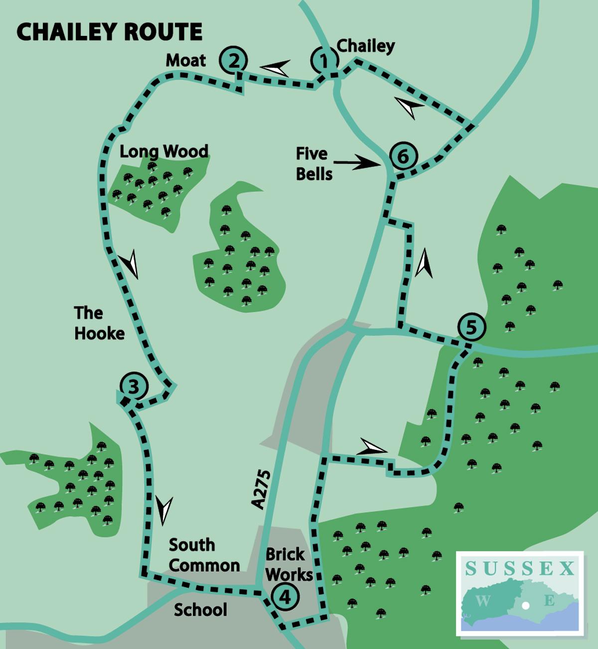
1 - From Chailey Green, upon which is the village sign with a windmill as its main feature, go towards the parish church. St Peter’s, established here in the 13th century, has plenty of interest inside, so take a look, if open.
Follow the lane that goes beyond the entrance to the churchyard, passing Church House and Church Farm on the left. On approaching the private entrance to Moat House, turn left where directed by a fingerpost.
In a short distance, turn right by a broken stile and another fingerpost. After about 150 yards, go over a long footbridge.
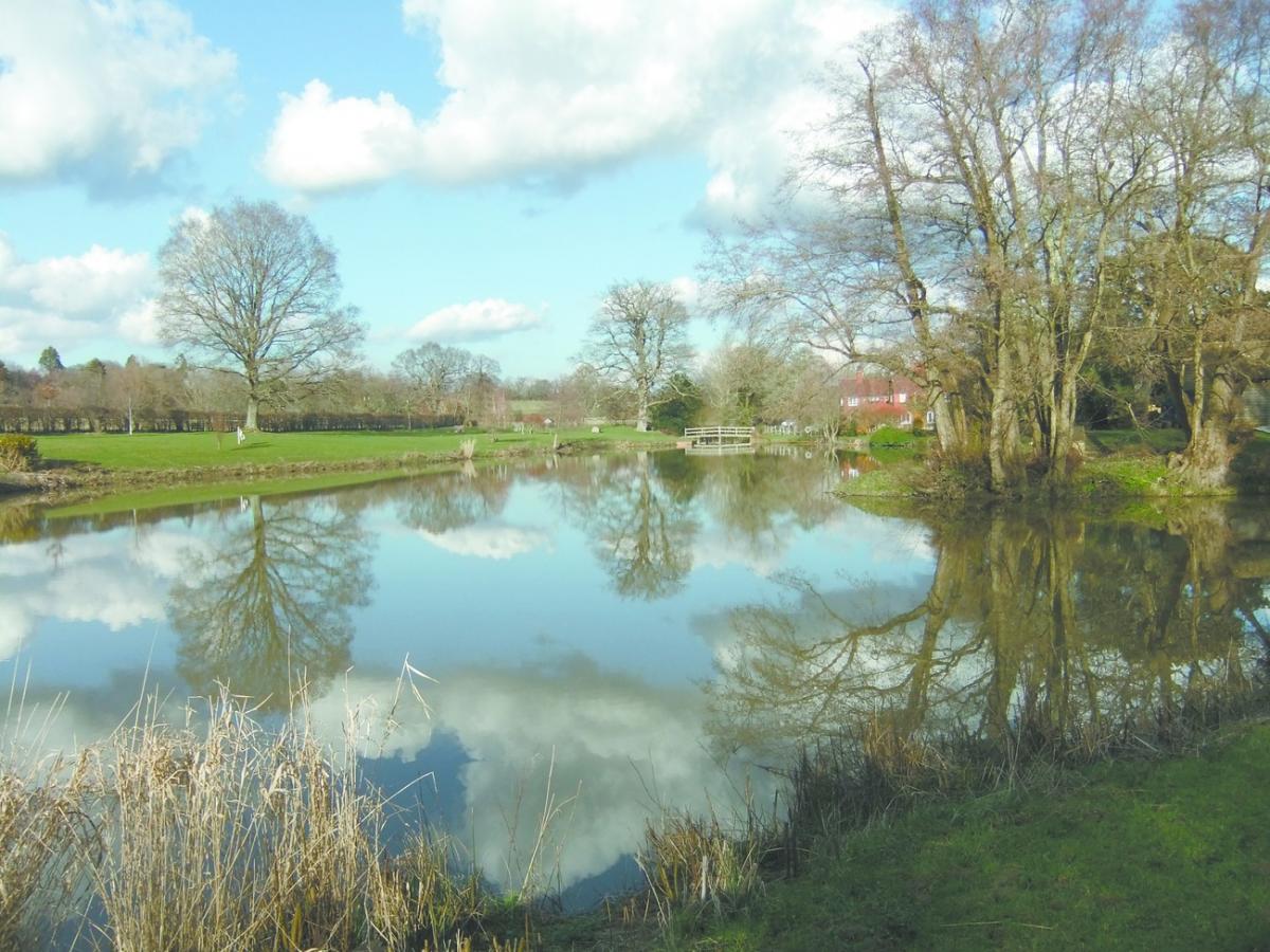
2 - Moat House is a Grade II listed timber-framed moated building, dating from the 16th century. However, it is the lake rather than the moat which is to be seen and admired over the fence on the right.
At the farther end of the lake, bear left in the direction indicated by a yellow waymark on an oak tree. Continue towards a metal gate and then go through a young woodland plantation.
Veer left into an open space, then veer right (south-west) towards another metal gate. Now bear left along a track to go over a footbridge.
In a short distance, ignore another footpath to the right, then follow the path along the edge of Long Wood, which is on the left. Here we join the Chailey Link walk, a route of six and a half miles around the parish; look for the waymarks with a colourful windmill logo.
At the end of the wood continue straight ahead and, in a short distance, go over a stile on the left. The large house to the right has the unusual name of The Hooke.
Continue direction (roughly south-east), cutting the corner of the next field, to cross another stile, then go uphill to enter a young woodland plantation. At the top of the hill, turn right along a track.
3 - In 200 yards, a few paces after the track veers to the right, turn sharp left on the track leading generally southwards. Follow this for about 700 yards, at first through woodland and then in the open.
Next bear left along a farm lane until coming to Mill Lane, opposite Chailey School. Turn left and look in the field to the left to see the remains of an old windmill.
Continue along Mill Lane, leading into South Chailey, until coming to the main road (A275). Cross over with great care and turn right along the footway opposite.
4 - Look around to see some decorative brickwork on a number of the older houses. In about 200 yards, turn left into Kilnwood Lane: a name which gives a clue as to what is to be found in this locality.
In about 150 yards, immediately before a residential cul-de-sac, turn left on a byway, known as Green Lane, which crosses Kilnwood Lane going uphill. As height is gained the brickworks can seen on the left, and the clay pit from where the raw materials are extracted is on the right. Traditional brick-making on this site has a history going back 300 years, due to the readily available Sussex clay here.
At the top of the hill, where a footpath crosses, continue straight ahead on the byway, following a flintstone wall on the right, for another 250 yards; hopefully the bluebells here will be still in flower. Immediately past a pair of metal gates bearing the name Caveridge Farmhouse on the right, go over a stile next to the gate pillar.
Follow the footpath alongside the fence and then, after about 400 yards, enter Marstakes Wood through a kissing-gate on the left. In a few paces, bear left by a fingerpost to follow the footpath. Waymarks are few and far between, so proceed in a generally northerly direction.
Near the end, the right-of-way veers to the left towards a farm but the path appears to be blocked and therefore unused. So, follow the clearer path which veers to the right, and then go through the gates in the flintstone wall ahead.
5 - Turn left along the road and, in about 300 yards, turn right at a leaning fingerpost on a footpath. In a few paces, by a pond on the left, go over what was a stile (cross tread missing) into a field.
Follow the path along the left-hand field edge, going slightly uphill for about 350 yards.
On reaching an oak tree in the hedge, turn left where there are a number of waymarks and cross the next field. Enter a narrow piece of woodland and, at a fingerpost, turn right along the footpath running parallel to the main road.
6 - At the road junction, turn right along Cinder Hill (beware as there is no footway). In about 400 yards, leave the Chailey Link Walk and turn left opposite the playing field. Our route back to Chailey Green is now along the Greenwich Meridian Trail (see GMT waymark) which closely follows the Greenwich Meridian for 273 miles from Peacehaven to East Yorkshire.
The path descends through a copse and then through a kissing-gate.
Follow the left-hand field edge and then alongside a flintstone wall to go through a metal kissing-gate.
Continue direction (south-west) towards a cherry tree and then turn left along the driveway to the main road (A275). Cross with great care to return to the Green.
- Distance/Time: Four and a half miles/two and a quarter hours
- By Car: Parking in parish church access road, west off A275 at Chailey Green
- By Public Transport: Buses (121) from Lewes and Newick to Chailey Green (very limited service at weekends and public holidays). Timetable information from Traveline: 0871 200 2233 or www.traveline.info
- What’s underfoot: Mainly field and woodland paths which may be muddy, if wet. Also, short distances along roads
- Thirsty Work: The Five Bells (near point 6)
- So you don’t get lost: OS Explorer 122 or Landranger 198, plus a compass for general direction
Click here for a full-sized map of the Chailey circular walk


Comments: Our rules
We want our comments to be a lively and valuable part of our community - a place where readers can debate and engage with the most important local issues. The ability to comment on our stories is a privilege, not a right, however, and that privilege may be withdrawn if it is abused or misused.
Please report any comments that break our rules.
Read the rules here