
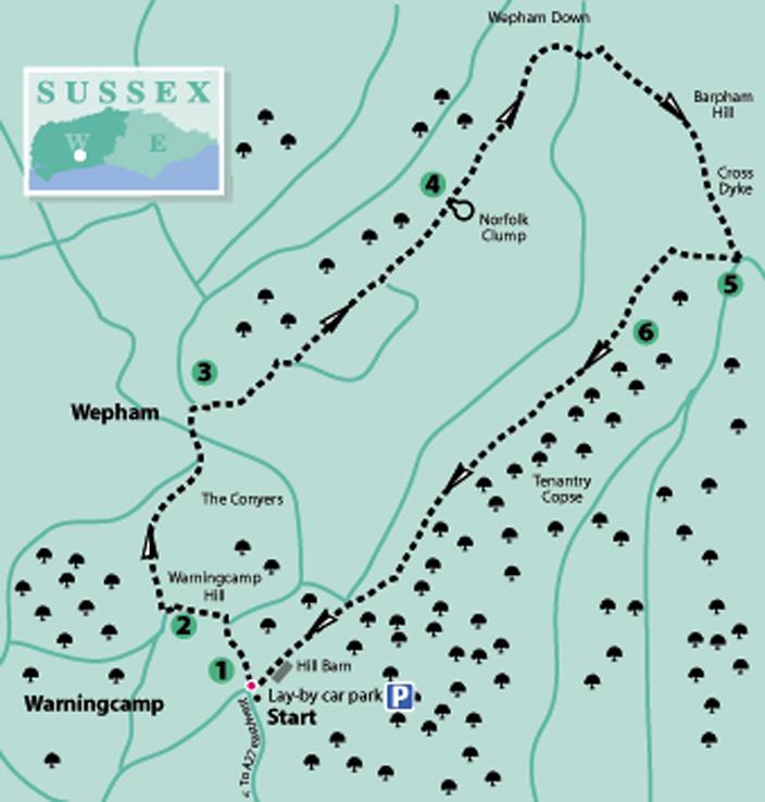
1 - From the car park lay-by go left to the bridleway (blue arrow) that rises between hedgerow – ignore the public right-of-way that leads off right from the lay-by. Follow the bridleway for 300 yards to a sharp right bend and in a few paces, beside a marker post, turn left (yellow arrow) through the hedgerow.
Cross a stile on to the footpath (slippery when wet), descend through the scrub for a short distance, coming to open hillside, and continue on a traversing descent to the valley floor.
Head for the obvious three-way marker post and there turn left on the bridleway (blue arrow), towards a second marker post 100 yards away.
2 - From the second post turn right, climbing a rising bridleway, passing through a bridle gate on Warningcamp Hill. In about 25 yards, at a fork in the track, take the right branch. Ascend through the woodland, passing through a bridle gate, crossing a track and continuing beneath low trees and scrub to go through another bridle gate on the hilltop.
Walk a few paces left to a hedge corner and then strike off across the field, bearing slightly right down to the opposite woodland – The Conyers. Enter the tree cover, bearing right, and follow the path, descending to a minor road.
Turn right along the road, soon turning left and entering the small community of Wepham. Climb beside houses (ignoring a right-turning bridleway) to where the road levels off. Keep to the roadside for a short distance and, just after a substantial brick building, once a grain store, locate and take the rising public footpath (yellow arrow) on the right, signposted for Lample House.
3 - Climb the surfaced driveway for a short distance and then continue on a grassy path, between gardens, to cross a stile. Walk up the left hedgeline in the rising field for 250 yards to the top left corner. Go left over a stile and bear right beside a rising bank, also on the right.
Climb to a path sign, cross the stile on the left and turn right up the field edge, passing a reservoir, which is off to the right, after a quarter of a mile and keeping direction. Cross a stile at the top right corner of the field and continue on the enclosed track.
In about 400 yards the path draws alongside the Norfolk Clump, off to the right. This circular hilltop copse has a name that is a reminder of whose land you are walking through; the notice forbidding access is a cautionary reminder, along with the feature’s name, of the summary justice that may be administered, should you decide to trespass.
4 - Keep to the main chalky track that continues north-eastward for nearly half a mile, shown as Gallops, to arrive beside a footpath sign. Do not take this left turn but continue ahead as the track takes a sweeping right turn at Wepham Down.
Walk towards a junction of gates and tracks, ignoring the first bridleway you come to that is on the left. Turn left from the gates, and a three-way sign, on to the second fence-enclosed bridleway on the left, and walk down this for 125 yards, and there turn right. Climb steeply at first, up the north-western flank of Barpham Hill, and as the slope eases, head for the hilltop copse. Follow the track between the bushes, towards and passing through double five-bar gates.
The final few feet of the ascent across the hilltop pass through an earthwork embankment, with a ditch on its western side and shown on the OS map as a cross dyke. The structure is a fine example of one of the many such boundary or defensive markers, possibly from the Middle Bronze Age, that exist across the South Downs. The top of the bank could also have been reinforced with a wooden palisade making a very effective border control between tribal territories.
Continue across the plateau-like summit, with an OS trig point off to the right, and head towards the far gates.
5 - Just before the gates (do not pass through them) turn right towards the nearby fence and then turn right again, back along the field edge on an unsigned bridleway. Follow the left fenceline for 300 yards to a corner and a marker post (blue arrow) and turn left.
Follow a faintly trodden track down the field, with fence and hedgerow off to the left. Bear very slightly right towards the lower end of the field and pass through a metal gate into the woodland of the Angmering Estate. Walk ahead a few yards into a clearing and pass over crossing tracks. Keep direction ahead on the bridleway (blue arrow), entering the woodland of Tenantry Copse.
6 - The route now keeps to the track, which can be very muddy in places after heavy rain, for one mile amid a wide variety of trees that are clearly being grown as part of an extensive managed woodland.
Keep to the main track through the woods, ignoring any of the side turnings and woodland drives as you proceed south-westerly. The bridleway finally joins a surfaced forest service track, here turn right, pass through a bridle gate and leave the woodland cover after a further 100 yards.
The track keeps direction, with a field on the right and passing Hill Barn in 300 yards. Continue for a further 250 yards on the track, arriving back at the starting point of our walk, beside the lay-by car park.
- Distance/Time: Five and a half miles, taking two and three quarter hours.
- By Car: Leave A27, 200 yards east of Arundel Station. Go north on Crossbush Lane for three quarters of a mile, turn right into Blakehurst Lane for half a mile, turn left at junction, follow to sharp right turn, park in lay-by. Start point grid ref: TQ046073.
- By Public Transport: No bus service to start of walk; walk from Arundel Station to start adds total of four miles to walk. Travel details from www.traveline.info, call 0871 2002233.
- What’s underfoot: Downland walking with two short climbs. Walking poles might be helpful on the descent in stage one, if wet underfoot. Possible with a baby backpack; not possible with a cross-country baby buggy.
- Thirsty Work: Nearest refreshments in Arundel.
- So you don’t get lost: OS Explorer Map 121 plus a compass for general direction


Comments: Our rules
We want our comments to be a lively and valuable part of our community - a place where readers can debate and engage with the most important local issues. The ability to comment on our stories is a privilege, not a right, however, and that privilege may be withdrawn if it is abused or misused.
Please report any comments that break our rules.
Read the rules here