
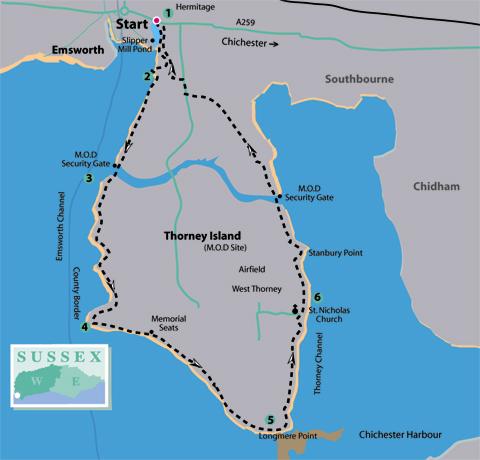
1 - A few yards from the county border at Hermitage, the last community in this part of Sussex, with Emsworth across the causeway in Hampshire, turn south into Slipper Road. Follow the road, with Slipper Mill Pond on the right, arriving in 300 yards beside the refurbished mill buildings, close to the pond outlet.
Keep left of the mill, walking ahead into a boatyard. Follow a gravel path, with care, between the boats, bearing left in a few yards to walk beside workshops and boatbuilding sheds. At the end of the buildings, with the inner marina ahead, turn left up a short ramp, then go right on a concrete access road for about 150 yards to crossing roads – note the footpath sign on the left.
Take the second turning on the right, a few yards ahead, walking to the far side of the boatyard and, with stacked equipment ahead, turn left.
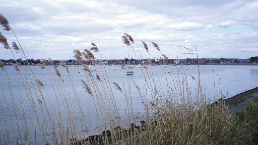
2 - Pass around a barrier, ignore a left turning, and take the southerly embankment path. The extent of the harbour and inlet now opens up, the county border is offshore, in the middle of the Emsworth Channel.
The island is noted for nesting and migratory birds, many of which can be seen by the eagle-eyed twitcher on this circumnavigation. Keep to the embankment path, there is a wider track down to the left if oncoming walking traffic is heavy.
After nearly three-quarters-of-a-mile the path arrives at the Great Deep, the original channel that separated the island from the mainland. The construction of the control sites in 1870, on both sides of the peninsula, permanently connected the island to the mainland but did little to minimise its remoteness.
With water swirling through control gates below walk ahead for a few yards to the security fence, a reminder that you are entering a Ministry of Defence (MoD) site. Mounted on the fence is a small yellow box, press the button and, when answered, advise the guardroom of your intention to walk the coastal path, the gate will be opened, pass through and be sure to close the gate.
3 - Bear right for a few paces around scrub on Wickor Point and resume a southerly direction. Cautionary signs advise walkers to keep to the path and not divert onto MoD land.
The path follows a more twisting route, passing around headlands, with tidal waters lapping against the sea defences.
After nearly a mile, having passed through gates, the path comes to Marker Point where an easterly direction is taken around the wide bay that extends to the tip of the island.
On this stretch of the walk the buildings of the military establishment and airfield runways, away to the left, come into view. When vacated by the Royal Air Force in the 1980’s, the base was used to accommodate refugee Vietnamese boat people and reverted to a military facility in 1984, when taken over by the Royal Artillery.
4 - The embankment path continues along the shoreline of the wide bay, south-eastward. In about half-a-mile the path arrives at a wider grass promontory, bordered to the north by Thorney scrub and with southerly views to where the navigable channels enter the sea; Hayling Island is to the west.
Of notable interest, at this point, are memorial seats that have been placed here in memory of two service men who lost their lives in recent conflicts. The families and friends of Steve Jones (Iraq 2005) and Sean Reeve (Afghanistan 2008) have chosen a moving spot to ask passing travellers to contemplate the soldiers’ sacrifice.
Take the path that bears half-left between the scrub, leaving the shoreline, and descending to cross a shallow gully. Turn right, with scrub on the right and the airfield on the left.
In half-a-mile the path clears the scrub, passes over a track leading to a slipway and continues south-easterly to Longmere Point, where a hide provides shelter and information for twitchers.
5 - The path now turns north, passing an off- limits causeway leading to Pilsey Island, a protected bird sanctuary, and continues for three-quarters-of-a-mile, between scrub and open shoreline, to the centuries-old settlement of West Thorney.
Follow the diverted path to the left, around the white- rendered sailing centre, if the shoreline path is not accessible, and head towards the 12th century church of St Nicholas.
The church is worth a visit to understand how the area has evolved over the centuries from a remote farming and seafaring community to a wartime and military location.
Walk north on the path to the end of the churchyard wall, descend a few steps to a slipway and turn left.
6 - The path continues north, diverting right and then left around Stanbury Point, to arrive in a quarter-of-a-mile at the eastern security control gate. Go through the unlocking procedure.
Continue northward for a quarter-of-a-mile to Thornham Point, pass through a squeeze stile and turn left. The path turns right after a few yards, passing houses in 350 yards. Keep to the minor road, ignore the Prinsted Lane right turning, and continue ahead to Thorney Road.
Turn right along the roadside for 200 yards and when beside a stable yard cross the road, go left and over a stile, into a paddock. Walk ahead to a stile at the far side; enter the marina site, turning right beside elevated cabins.
In 150 yards, at the point we were at earlier, continue ahead between boats, turning left beside the administration buildings, and then right past workshops. Thread a route between boats to Slipper Mill. Continue north along the road to our starting point.
Distance/Time: Seven-and-a-quarter miles taking three-and-a-half hours
By Car: Drop-off and pick-up on A259 coast road at Hermitage, near Slipper Mill Pond. Local roadside parking in Thorney Road. Emsworth is across the causeway. Start point GR SU754058
By Public Transport: Coastliner bus service 700 from Old Steine, Brighton, or Marine Parade, Worthing, via Chichester to drop-off and return bus at Hermitage – approximately three-and-a-half hours. Travel details from www.traveline.info or call 0871 2002233
What’s underfoot: Level coastal walking on well-defined paths, a few gates and one squeeze stile. Contact through intercom on entering and leaving MoD section. Possible with a baby backpack and just about possible with an off-road baby buggy, path is narrow (stage 2) and you need to
negotiate the squeeze stile (stage 6)
Thirsty Work: Refreshments available at The Sussex Brewery, Hermitage, on the A259
So you don’t get lost: OS Explorer Map 120 plus a compass for general direction


Comments: Our rules
We want our comments to be a lively and valuable part of our community - a place where readers can debate and engage with the most important local issues. The ability to comment on our stories is a privilege, not a right, however, and that privilege may be withdrawn if it is abused or misused.
Please report any comments that break our rules.
Read the rules hereLast Updated:
Report this comment Cancel