
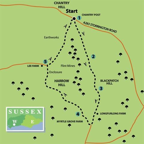
1 - From the prominent Chantry Post and adjacent parking area, head for the gate that is on the south side of the South Downs Way (Angmering Park Estate sign on the gate). Pass through the gate, taking the bridleway that bears left across the top of the arable field and indicated on the signpost as heading for Longfurlong.
The bridleway descends from the hilltop, passes through a bridle gate, maintaining direction to a fence, where the track turns right. Follow the fence-side bridleway, ignoring a left turning in a short distance, and heading towards metal gates, after three-quarters-of-a-mile.
2 - From the gates, keep to the bridleway that climbs (south-easterly) the northern spur of Blackpatch Hill – ignore the right branching bridleway in 100 yards. The path skirts around the western flank of the hill on a well-graded track.
The trig point on top of Blackpatch seems to beckon as you climb the bridleway and although this is not Open Access ground, there is a model aircraft launch site near the top of the hill. An investigation by the inquisitive walker may be an urge too tempting to resist – on your head be it.
Blackpatch, is the site of extensive Neolithic flint mining and was investigated by local archaeologist John Pull in 1922. The excavation revealed more than 100 filled-in shafts, which had been sunk to a depth of about 12 ft. Galleries radiated out from the shafts to extract flint from seams. The flint in the lower seams being favoured as it was more easily worked (knapped) than weathered, surface flint nodules.
The industry was operating from around 6,000 years ago (4,000BC), when the period of the hunter-gatherer was ending and farming evolved, with people settling into communities. It was a time before the building of Stonehenge and the construction of the Great Pyramid at Giza, in Egypt. Here, hills were being de-forested by flint axes, there was industry, farming, social organisation and trade. Thoughts for the interested hiker to ponder.
3 - Return to the bridleway, if you have trespassed to the summit, and resume direction, passing through gates and bearing right on the bridleway beside hilltop beech trees. The track heads in a southerly direction for nearly half-a-mile, arriving beside Longfurlong Farm. Pass by the buildings and horseboxes, keeping to the bridleway and in 300 yards at a junction of metalled surfaces, turn right towards Myrtle Grove Farm.
The access drive bears right in 100 yards and heads towards the busy business units. There are, amongst others, farm machinery workshops, a dairy, even a coffin maker. In the 1930s the area was largely taken over as an Army training ground and photographs show regimented rows of tents across the Downs (for pictures see www.findonvillage.com).
Walk to the far side of the yard and, with the estate office ahead, turn right for a few yards then bear left (yellow arrow) up an access ramp. Take a left fork in the track, heading towards a parking area in front of cottages. Walk to the far right corner, crossing a stile into a paddock. Go quarter-right, over a succession of five small paddocks to a wider track and three-way path sign, there turn left down the hillside.
4 - The path descends beside a fence to the bottom of a shallow valley, then climbs to go over a stile, with hedgerow off to the left, to a crossing bridleway. With a marker post ahead (blue arrow), beside a wooden power cable pylon, keep direction up the hillside following the line of pylons. At the third post from the bridleway, turn half-left towards a bridle gate in the fenceline, about 150 yards away. Cross to a farm drive and go right for 300 yards to where the drive turns left and there are gates on the right. Ignore the right footpath sign and walk to the metal bridle gate, a few yards off the drive.
Follow a north-westerly bridleway (blue arrow) across an arable field for nearly 400 yards. This part of the walk is across the southern flank of Harrow Hill. The hill was the site of Neolithic flint mining and in the 1930s was excavated by the father and son archaeologist team of Cecil and Eliot Curwen; around 200 mining shafts were found across the hilltop, a later Bronze Age enclosure also crowned the summit.
The path passes through a gate at the top of the field, continuing on an obvious track to follow a descent of the hillside. Pass through intermediate gates, heading for the far left corner, close to the barns at Lee Farm.
5 - At the field corner pass through the gate, go right for a few paces (there’s a large barn on the left) then turn right onto a wide track that in a few paces bears left.
The path begins a climb towards the top of the Downs; away to the right is a small quarry cut into the hillside. After about one-third-of-a-mile the path bears left and continues its ascent of the fence-side bridleway. Just keep going, you will get there soon, passing through any gates across the track.
As the track levels-off (it does eventually) you will see to the left, across a shallow valley (Chantry Bottom), some evidence of earthworks and a field system. The site is a Scheduled Ancient Monument and excavations have revealed a pattern of Roman-period field systems, house platforms and a medieval farm site. With the earlier flint mining on nearby hills, right up to modern agricultural, this part of the South Downs has been witness to thousands of years of progress and development.
The bridleway continues northward, back to the fence and gate from which the walk began at Chantry Post.
- Distance/Time: Six-and-a-quarter miles, taking three-and-a-quarter hours.
- By Car: Chantry Post is one-and-a-half miles south of the A283 road, at the eastern side of Storrington. Follow Chantry Lane to Chantry Post car park. Start point Grid Ref. TQ087120.
- By Public Transport: No public transport to start, leaving the bus at Chantry Lane in Storrington will add total of three (steep) miles to the walk. Travel details from www.traveline.info, phone 0871 2002233.
- What’s underfoot: Downland walking on well-defined paths and bridleways; climbs and stiles on the way. Tough going with a baby backpack but possible. Not possible with a baby buggy.
- Thirsty Work: No refreshment on route, nearest pubs and cafes in Storrington.
- So you don’t get lost: OS Explorer maps 121 plus a compass for general direction.


Comments: Our rules
We want our comments to be a lively and valuable part of our community - a place where readers can debate and engage with the most important local issues. The ability to comment on our stories is a privilege, not a right, however, and that privilege may be withdrawn if it is abused or misused.
Please report any comments that break our rules.
Read the rules here