
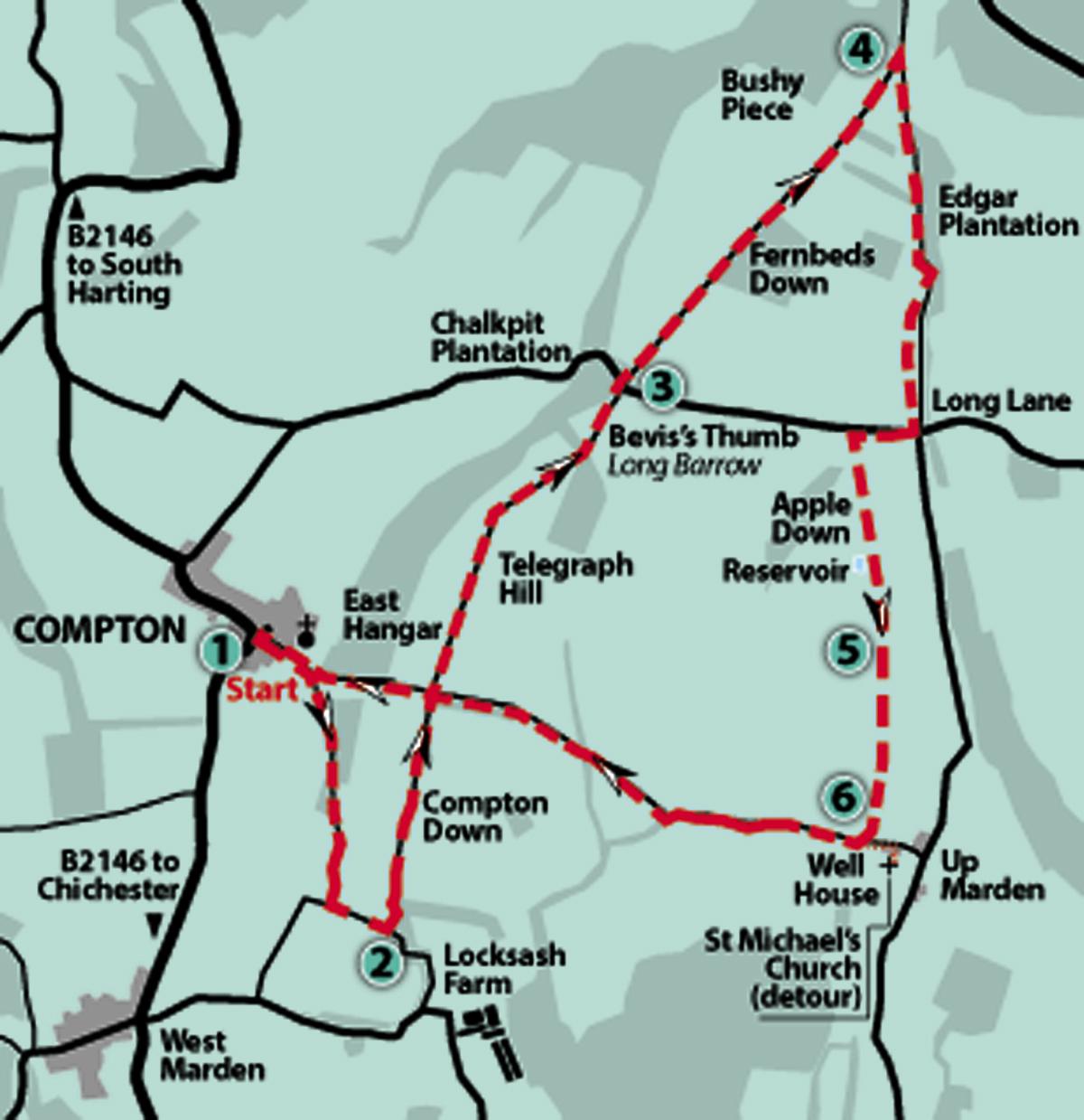
1 - From the village square in Compton, just off the B2146 road and bordered by its Village Shop and The Coach And Horses pub, keep right of the village well and head up the unsigned School Lane.
After the last of the houses and the village primary school, leave the access road and continue up the hill on a track to arrive beside a path sign.
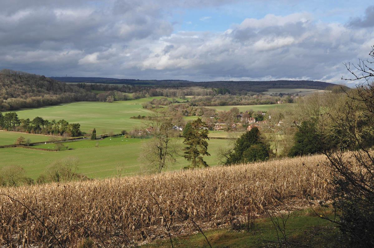
Take the right forking bridleway, climbing the hillside between banks, with occasional glimpses across the valley through hedgerow on the right. The gully track climbs for about a quarter of a mile, then bears right and levels off, with the valley view becoming more expansive.
On coming to a three-way bridleway crossing, turn left for 200 yards to a second three-way sign, next to a Scots Pine plantation.
2 - Turn left on a wide flinty track, northward across Compton Down, soon leaving the shelter of the plantation and coming to open hilltop.
Keep to the main track for half a mile to arrive beside a second plantation and a four-way marker post.
Take neither left nor right turnings but continue ahead on Telegraph Hill, keeping to the bridleway, with the distant hilltop house visible 400 yards away.
Telegraph Hill marks the location of an Admiralty semaphore signalling station, which operated from 1822 to 1847 as part of a chain of sites from London to the naval base at Portsmouth – we have encountered other stations on earlier Argus walks. Messages from Whitehall to naval command at Portsmouth were transmitted in a few minutes, the system being much speedier in times of national emergency than using post riders.
Pass by the isolated hilltop Telegraph House, with its fine, wind-shedding hedgerow, and keep to the track as it begins to descend – East Hanger is down the hillside on the left. To the north there are fine views towards the National Trust property of Uppark House.
The track bears right after 300 yards, continuing towards a line of trees and then keeping direction to the bottom of the bridleway.
Just before a minor road note the long, raised hummock on the right, this is Bevis’s Thumb, a Neolithic long barrow. Bevis is famous for designating his burial spot by hurling a sword from the battlements of Arundel Castle and here it landed. As befits a giant’s appetite, he would eat a whole ox and swill it all down with copious amounts of ale.
You may decide, in honour of an ancient gourmet, to have your cucumber sandwiches at this hallowed spot.
3 - Cross over the minor road, passing by Chalkpit Plantation, and walk along the right hedgeline on Fernbeds Down.
This stretch of hilltop bridleway continues for three-quarters of a mile, passing by a right-turn footpath beside a copse and cross-country riding jumps, to arrive at a three-way junction next to the woodland of Bushy Piece.
4 - Take an almost right about turn to shortly walk beside Edgar’s Plantation on Handle Down. After nearly half a mile, the footpath turns left for a few yards, at the end of the copse, and then right (ignore the left and right signed footpath options) to continue down the pasture to the bottom left corner.
Cross a stile on to Long Lane and turn right up the hill. In 200 yards, at the top of the hill, go left through a metal gate on to a wide track which traverses the eastern flank of Apple Down.
Pass close to the top of the hill along the right fenceline, with a tree-bordered reservoir at the summit. There are views to the north, back towards the prominent Beacon Hill, an Iron Age enclosure.
Continue down the southern side of the hill for about 100 yards to a stile in hedgerow.
5 - On crossing the stile, a view opens up to the coast and the Isle Of Wight, with the busy shipping channels and ships vying for access to Hampshire’s ports. The field- centre footpath (probably not re-instated) goes ahead down the next field, aiming for a woodland corner in a quarter of a mile.
At the woodland corner, there is a marker post. Continue ahead for a further 300 yards to the left-field corner and a wider bridleway track at Up Marden.
As a detour, turn left up the track and in about 75 yards, divert right along a path to the church of St Michael. This remote, tiny and unspoilt centre of worship, with its restored wall painting fragments, was once the spiritual centre of a busy rural community. Now it has few visitors – you can be one of them. The church has been described as one of the loveliest in England. On the south side of the churchyard is a restored well house.
6 - Return to our four-way arrival point on the descending bridleway and continue down the gully track. In about a quarter of a mile, pass over a crossing field track and follow the narrowing bridleway to the valley floor.
Pass across the bottom of the valley – there are the remains of a stockade and farm machinery on the left – and take the opposite, hedge-enclosed, north-westerly rising track.
After a climb of 350 yards, cross over a junction of field access tracks, amongst hedgerow, and keep direction up the next field towards a hilltop plantation. Walk beside the stand of Scots Pine to a four-way junction that we passed through earlier.
Locate the opposite field opening and footpath, through a hedge, and follow the descending right-field edge – the houses at Compton now come into view.
The path draws alongside East Hanger and towards the bottom of the slope bears slightly left to arrive close to the bridleway we took at the beginning of the walk.
Bear right down the track, soon passing the village school and arriving back at our starting point in the village.
Distance/Time: Six miles taking three hours
By Car: Compton is on the B2146 road, a few miles south of South Harting and the National Trust property at Uppark House. Start point GR SU776148
By Public Transport: Emsworth and District No. 54 bus from Chichester to Compton, journey time about 30 minutes. For full travel details, call 0871 2002233 or visit www.traveline.info
What’s underfoot: Western Downland walking on well-drained paths and bridleways, some stiles, a few easily negotiated climbs and a possibly slippery descent near Up Marden. Possible with a baby backpack but tough going. Not possible with an off-road baby buggy
Thirsty Work: The Village Shop And Tearoom and The Coach And Horses in Compton village
So you don’t get lost: OS Explorer Map 120, plus a compass for general direction


Comments: Our rules
We want our comments to be a lively and valuable part of our community - a place where readers can debate and engage with the most important local issues. The ability to comment on our stories is a privilege, not a right, however, and that privilege may be withdrawn if it is abused or misused.
Please report any comments that break our rules.
Read the rules hereLast Updated:
Report this comment Cancel