
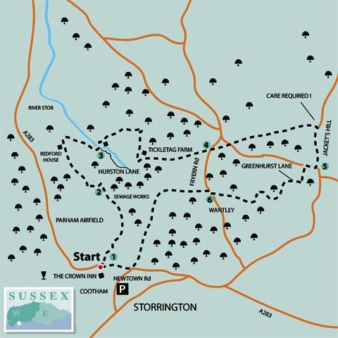
1 - From the roadside on the A283, opposite Chapel Lane and 100 yards west of The Crown Inn, take the footpath that heads northwards, turning left in 50 yards and passing cottages that are off to the right.
In a few yards turn right, heading towards a caravan site. Continue between the caravans and at the end of the estate bear left, with a row of garages on the left. Enter scrub and low trees, going right over a plank bridge, climbing a bank and turning left at a path junction. Skirt left around the top of an embankment, above a stream, going left over a bridge and then turning right.
Follow the path for about 100 yards, climbing a bank on the left up into Parham Airfield, now used by the Southdown Gliding Club. Turn right along the hedgeline, keeping to the field edge as the path sweeps to the left. Keep to the hedgeline for nearly half-a-mile, passing a clearing at the mid-way point that offers a fine view of a sewage works.
2 - Continue to the end of the hedge and, with hedgerow ahead, turn left for 100 yards towards the field corner. From the corner, turn right on an enclosed path, climbing towards trees. The path bears right through the copse, ignoring a left turn, and passes through a gate, descending to a minor road.
Turn left up the road for a few yards and branch right, onto a surfaced bridleway. Follow the bridleway for one-third-of-a-mile, passing Redford House and descending for 150 yards to a footpath that climbs right.
At the top of the bank cross a field-edge stile, taking a half-right line to an opposite stile. In the next field keep direction to the far left corner, cross a stile and walk ahead to Hurston Lane.
3 - Turn left, crossing a road bridge above the River Stor, a tributary of the River Arun, and at a right turn take the left bridleway up a slope towards Lower Hurston Barn. After the first buildings on the right, turn right onto a bridleway, leaving the farm site and coming to a path junction in 100 yards, at the edge of a golf course.
Take the right bridleway branch, crossing the course on a sandy path for 250 yards, heading for the opposite copse. Bear right in woodland, following the bridleway, which joins a driveway, clears the copse and in a few yards turns right through a gate onto a level, sometimes marshy, meadow.
At the far side of the field climb a track between trees and when beside the entrance to Tickletag Farm, turn sharply left, between stone gateposts, up a ramp. Bear right at the top of the climb and follow the ridge-top footpath, with views across the surrounding farmland.
The path keeps to the ridge for nearly three-quarters-of-a-mile, passing over a crossing footpath at the mid-point and maintaining direction, then descending beside a dwelling, to cross a minor road.
4 - Take the opposite path, passing more dwellings, and in 50 yards descend to cross another minor road. Climb the opposite bank and stile to continue along the left edge for 400 yards.
Pass over a gully, and a crossing bridleway, and continue eastward. In the next section, divert left a few paces at the mid-point, continuing beside a right fence and tree line.
In 250 yards the path diverts right onto an enclosed path (very enclosed in places!) for 300 yards, continuing beside a high fence that surrounds a house on the right.
The path turns abruptly left for 100 yards, above the roadway that is in the deep cutting below. Descend steps to the roadside and turn right along the road edge of Jacket’s Hill. Extreme care is required on this short section – the road is busy and facilities for pedestrians are non-existent. Keep close to the edge and take particular care of children and dogs.
In 400 yards go right, across a verge onto a service drive in front of houses and maintain direction to Greenhurst Lane.
5 - Turn right along the road for 200 yards, taking a left footpath turning, around a metal gate, signed White Cottage. Climb beneath scrub and bushes, crossing a stile and a short section of field, to a right turning.
Follow the left field-edge along a hedge line, into a narrow more overgrown section and a left corner stile. Turn left down the next field edge and at the bottom corner follow the path around to the right.
At the end of the field, in about 250 yards, divert left through bushes, skirting around a remote cottage and through a kissing gate to a minor road. Turn left, ignoring a left turning, and climb for 100 yards to a three-way path junction at East Wantley. Turn right, passing between hedgerow and rail fences, to descend steps after 400 yards and take a few paces right to a drive, close to West Wantley Farm.
6 - Walk left along the drive to Fryern Road, go right for a few yards and cross to a footpath that passes across two fields, keeping to the left edge, with stiles and plank bridges.
In a third field the path descends into hollow and in a few yards bears left, crossing a hedgerow stile. Walk half-right beside a copse (ignore a right turn) and cross a stile beside a metal gate. Follow a trodden path across a paddock, then an enclosed path to a road.
Go left along the road, Hurston Lane, for about one-third-of-a-mile, keeping to the pavement, where possible.
At the A283 road, cross to the opposite path, turning right towards The Crown Inn at Cootham or down New Town Road to parked vehicles.
- Distance/Time: Seven miles, taking three and a half hours
- By Car: Cootham is on the A283 about one mile west of the centre of Storrington. Very limited parking at Cootham. Turn south into New Town Road, 400 yards east of start point, for on-street parking, then walk to start. Start point GR: TQ074145
- By Public Transport: Bus stop for both directions a few paces from the start point, 100 yards west of The Crown Inn. Travel details from www.traveline.info, phone 0871 2002233
- What’s underfoot: Mainly level walking, with a few short bank climbs. Care required on Jacket’s Hill with roadside walking in section four. A long way with a baby backpack, not possible with a baby buggy
- Thirsty Work: The Crown Inn at Cootham, or cafes and pubs in Storrington
- So you don’t get lost: OS Explorer map 121 plus a compass for general direction


Comments: Our rules
We want our comments to be a lively and valuable part of our community - a place where readers can debate and engage with the most important local issues. The ability to comment on our stories is a privilege, not a right, however, and that privilege may be withdrawn if it is abused or misused.
Please report any comments that break our rules.
Read the rules here