
This walk follows a linear route across the Downs.
You have to make the effort to succeed on the expedition as it involves getting a bus to the start and away from the finish. Of course, you could get dropped off by car and get picked up at the other end, but you’ll be missing the spirit of the whole campaign.
This walk is about reducing your carbon footprint by getting there the old-fashioned way – on the bus.
Give it a try – you’ll feel the warm glow of satisfaction as you journey back. By the way, it is a good walk.
To start, you have to get into central Brighton and catch the number 77 bus. The bus goes from Brighton Pier, via Brighton Station and Dyke Road, to the Devil’s Dyke Hotel. (See essentials below.) Look upon the ride as part of the journey, sit upstairs, take a look into people’s gardens and be amazed at the far-reaching views across open hills, in all directions, as you clear the urban surroundings.
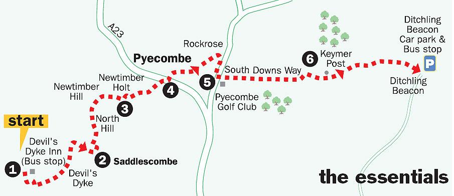
1. Having arrived at the bus terminus beside the Devil’s Dyke Inn, take in the view over the Weald and then head for the western side of the inn. Turn down the approach road you have just arrived on, following the grass verge past a car park, on the left of the road, for 200 yards.
Turn left at the signed bridleway, dropping through the scrub to turn right at a bridle gate. Pass right around the top of the deep hollow that is the Devil’s Dyke and, in a few yards, turn left to begin a steep descent on open access land.
Follow the valley bottom path, clearing the steep sides and veering left after halfa- mile. Head for a wooden bridle gate in 150 yards on the right and enter a tree-covered bridleway.
In 150 yards at a marker post (yellow arrow), turn right up a steep bank, on steps, crossing a stile into a sloping field.
Walk up the left field-edge for 200 yards to a metalled track.
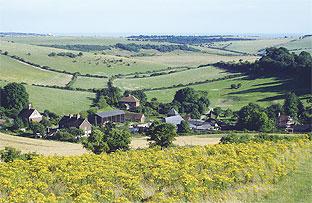
Turn right up the track to the roadside at Saddlescombe.
2. Cross, with care, towards the farm, following the drive ahead for 50 yards. When opposite the first house, turn left through a bridle gate.
From the gate, turn left up a path, leading to a metal gate and stile.
Cross the stile into the next field, turning right up the hill, on open access land. Follow the hedgeline for 250 yards, diverting left away from the hedge, to follow the obvious track to a point where it begins to level-off.
On passing two isolated trees on the left of the path, a sycamore and an oak, keep to the main path. Take neither of the paths branching to the right, but continue ahead.
Follow the path as it swings to the right across the top of Newtimber Hill, with a treeline off to the left, and pass between isolated bushes and trees.
After about 400 yards the path turns half-left and, in a few yards, goes right between blackberry bushes. Continue ahead to a hedgeline, seeking out and passing through a bridle gate concealed in the bushes, a few paces to the left.
3. Turn left down the bridleway (blue arrow) for no more than 100 yards. Locate an opening in the right hedgerow, about ten yards before a stile on the left. Take the unsigned right turning, climbing to the right, then going left to follow the bridleway at the edge of Newtimber Holt. Keep to the cattle-churned track for 200 yards to a bridle gate and National Trust sign.
Continue down the bridleway to gates in 300 yards.
Take the path that leads down the hill, to cross the footbridge over the A23 road at Pyecombe.
4. At the junction with Pyecombe Street, turn right for 75 yards, then turn left up a drive beside a house (yellow arrow), climbing to a stile that leads into a farmyard. Go to the far right end of the yard to a kissing gate and take a line half-right to the top corner of the field.
Cross a stile through scrub to a further field-edge stile and follow the path over the flank of the hillside (yellow arrows), descending to a stile and crossing bridleway. Walk through the hedgerow opening opposite to a stile into a paddock and cross to the half-left corner at Rockrose.
Turn right down a drive and before the road turn right through a gate on to a permissive bridleway (white arrow), descending steeply into hedgerow. Follow the track for 400 yards to a junction with the South Downs Way (SDW) at the roadside.
5. Turn left, cross the road with care, to the entrance to Pyecombe Golf Club and climb across the car park, keeping to the left.
Take the onward rising SDW track that is left of the golf course, climbing for nearly three-quarters-of-amile to a bridleway junction.
Do not turn left on the SDW.
Continue straight ahead for one-third-of-a-mile, turn left through a bridle gate and in a further 100 yards rejoin the SDW.
6. Turn right, eastward, and follow the broad SDW for one-and-aquarter miles to the final climb across Ditchling Beacon. On the way walk past the Keymer Post, a sign that indicates the distant destinations of Eastbourne and Winchester.
Your arrival at Ditchling Beacon car park may be greeted by a cornet, not the brass band variety but an ice cream one with a chocolate flake – there is usually an ice cream van in the car park.
As the 79 bus bounces along Ditchling Road you may remember that nursery song, “The wheels on the bus go round and round, round and round...” and feel just slightly smug, with that satisfied glow, knowing you have minimised your carbon footprint.
- Distance/time: Six-and-three-quarter miles, taking three-and-a-half hours.
- By car: You’re supposed to be on the bus! The Devil’s Dyke is at the end of the Devil’s Dyke Road, signposted from the A27, Brighton bypass. Ditchling Beacon National Trust car park is two-and-a-half miles north from the A27 at the Hollingbury turn-off. Start point Grid Ref. TQ258110.
- By public transport: Brighton & Hove Bus Service 77 runs hourly on Sundays and Bank Holidays, via Brighton Pier, Brighton Station to Devil’s Dyke – more frequently in summer months. Service 79 runs hourly from Ditchling Beacon to Old Steine, Brighton, via Ditchling Road. For detailed times of both services ring 01273 292480.
- What's underfoot: Downland walking with some steep climbs and descents on footpaths, bridleways and open access land. Possible with a baby backpack. Not possible with a baby buggy.
- Thirsty work: The Devil's Dyke Inn at the start and an ice cream van at Ditchling Beacon.
- So you don't get lost: OS Explorer map 122 and a compass for general direction.
For a full-sized version of the map, see 'related links' above.


Comments: Our rules
We want our comments to be a lively and valuable part of our community - a place where readers can debate and engage with the most important local issues. The ability to comment on our stories is a privilege, not a right, however, and that privilege may be withdrawn if it is abused or misused.
Please report any comments that break our rules.
Read the rules hereLast Updated:
Report this comment Cancel