
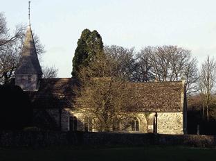
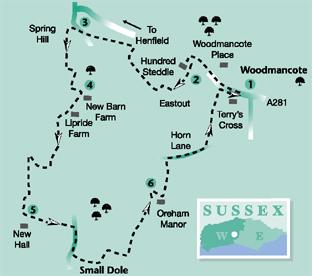
1 - From the bus stop beside Terry’s Cross, on the A281 Henfield road, cross to the opposite pavement beside the Parish Hall, and turn left, walking west. In 350 yards the path passes the entrance to the parish church of St Peters and in a few yards, just after a driveway, diverts a few paces right on to a continuing, enclosed bridleway. Maintain direction up a low rise for 300 yards to a path junction. Go left through a bridle gate, cross the road and turn left for 50 yards. Turn right at the entrance of Hundred Steddle and follow the driveway between residences, diverting to the quarter-right after 250 yards and descending towards Eastout.
2 - Just before a five-bar gate entrance, note the footpath sign and steps up a bank on the right – take this turning. Walk along the left hedgeline for 100 yards and turn left down the field edge for a few yards to the left corner. Pass through the hedgerow and turn right, keeping to the hedgeline for 250 yards. Cross over a track, through hedgerow, and continue into the next field, finally crossing over a second track between two ponds. Walk on for a few paces up a rising path and then turn right to climb steeply up a right field-edge. In 150 yards, at the field corner, turn left. Walk along the undulating path, across the top of the sloping field, passing some well-located seats that offer fine views to the Downs. After a quarter of a mile the path descends half-right, among scrub and trees, to the roadside.
3 - Cross the road with care and locate the opposite track that diverts half-right on to King James’s Lane in a few paces. Walk through a small residential estate and continue for 75 yards to a five-way path junction. Turn left down Spring Hill, along a raised section of track, crossing a bridge over a tributary of the River Adur, and passing a second five-way path sign. Climb to the top left corner of the next field, crossing a stile on to a metalled driveway. Turn left along the drive, beside some dwellings, and in 100 yards divert right to a stile. Cross into a field and climb the enclosed path to the top right corner. Turn left along the top of the field to cross a stile on the right in 150 yards, close to New Barn Farm.
4 - Go right of the farm buildings on a wide track, enclosed by hedgerow. On coming to the isolated house at Lipride in 350 yards, pass through the wooden gate and walk ahead for 100 yards, to draw alongside a three-way sign. Turn left, crossing a stile in a few yards and climbing up the left field-edge. Continue across the top of the field, diverting slightly right through a metal gate and heading to a left field corner. Turn right along the stream bank, another tributary of the River Adur, and in 300 yards go left over a brick-built bridge. Follow the mid-field path for a quarter-of-a-mile to a crossing farm track. Turn right up the track for 75 yards and, at a junction, turn left, heading towards the buildings around New Hall. On drawing alongside a large bungalow on the right, turn left.
5 - Follow the lane, through the outskirts of Small Dole to a main road in one third of a mile. Cross the road and turn right, following the roadside pavement and crossing over Tottington Drive after 300 yards. Continue for a further 100 yards to Sands Lane and turn left. Walk up the residential road and, after the last dwelling on the left in 400 yards, divert left up a bank. Climb beside a fence to the top of the rise to arrive beside farm buildings. Pass around a fence post beside a green barn and immediately turn right between a barbed wire fence and the green wall of the barn. In a few yards cross a stile, following a field-edge path across the top of the hill for 200 yards to a metal kissing gate on the left, just before the farm at South Tottington Sands. Go left through the gate and descend the field towards a gate with access to a footbridge. Cross the bridge and a short section of marshy ground to a second bridge. Climb to pass through another metal gate. Continue up the next field, to a level section and divert quarter-right along the hedgerow, passing beneath the bushes and across a shallow gully. Walk ahead over a small meadow and along a left garden hedgeline. Just after a stand of fir trees, at the end of the hedgerow, turn left, soon veering right up a driveway to a crossing track and path junction.
6 - Turn right up the track and, just before Oreham Manor, in 150 yards, go left over a stile. Climb to the top of the field, crossing a stile and maintaining direction beside a left hedgerow. In a few yards divert half-left through a small copse. On emerging from the tree cover, continue ahead with a drainage ditch on the right, passing beside Woolvens cottage and descending to the roadside. Turn right along Horn Lane, keeping to the grass verge, where possible, for a quarter of a mile and, at a left bend in the road, locate a bridleway sign in the left hedgerow. Turn left on to the wide bridleway and follow this for half-a-mile, descending to cross a stream and then climbing between enclosing hedgerows to the roadside. Cross the road to the opposite verge and pavement and turn right, back towards the bus stop at Woodmancote.
* Distance/Time: Six-and-a-half miles taking three hours.
* By Car: Limited roadside parking at Woodmancote, nearby lay-bys offer some space for cars. Start point Grid Ref: TQ234147.
* By Public Transport: For bus details visit www.traveline.info, or call 0871 2002233. The number 17 Brighton to Horsham bus stops at the start point.
* What’s underfoot: Mainly level Wealden walking with some muddy sections after heavy rain. Possible with a baby backpack; not possible with a baby buggy.
* Thirsty Work: No facilities on the walk, nearest pubs and cafes at Henfield.
* So you don’t get lost: OS Explorer 122.


Comments: Our rules
We want our comments to be a lively and valuable part of our community - a place where readers can debate and engage with the most important local issues. The ability to comment on our stories is a privilege, not a right, however, and that privilege may be withdrawn if it is abused or misused.
Please report any comments that break our rules.
Read the rules here