
1 - From the Whiteways car park, leaving behind the bikers, buses and snackers, head for the gate, which is about 50 yards north of the cafe. Take the bridleway (blue arrow) that enters Houghton Forest. The track at first heads north-west and then bears left, passing knobbly, ancient beech trees and later some younger coppice and a sprinkling of firs – all in the care of the Forestry Commission.
In 250 yards, the bridleway passes between a barrier, beside a large noticeboard, then bears left, descending to a junction of tracks; keep to the bridleway (blue arrow) going left, soon crossing a working track.
Continue ahead to commence a climb between the plantations, the track levelling-off after a few hundred yards.
On coming to a left-turning bridleway, ignore this option and walk ahead on the main track for 250 yards to a left turn and marker post, turn left (blue arrow). In 75 yards, the track comes to a clearing above a sloping meadow.
2 - Turn right into Trot Row for about 400 yards, finally leave the woodland, through a tree tunnel, to cross a field- centre bridleway. The wide track then passes beside Stammers Copse, heading to a four-way bridleway junction at Little Bottom, after a quarter-of-a-mile.
Continue ahead, beside Stammers Wood, descending into a clearing with prominent and magnificent fir trees acting as markers. Pass across the bottom of the shallow bowl and climb to a fork in the tracks.
Take the left path through a short section of woodland to arrive beside an arable field (marker post), extending north and south.
Turn right for a few yards to a second post and there turn left across the field, entering the opposite woodland. Enter the tree cover for about 25 yards to a crossing track and turn left.
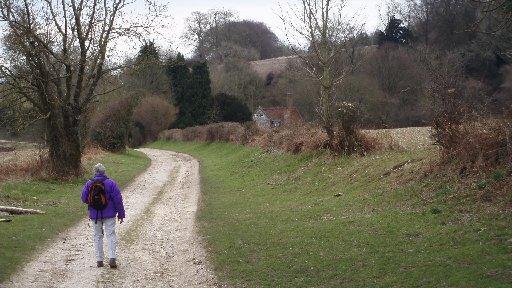
3 - In 50 yards, the bridleway passes through a gate onto Great Down. This glorious sweep of open hillside has all that is essential South Downs, the close-cropped, velvety grass descending on all sides and wide, wide views down to the coast and away westward to the distant line of hills – topped by Halnaker Windmill.
This is downland across which to stride and sing, whistle a cheery tune, talk to yourself, laugh out loud at your own jokes and gambol carelessly, safe in the knowledge that there will be no men in white coats to carry you off to a place of public safety at the end.
Walk ahead on the trodden path, down the hill for about half-a-mile and pass, smilingly, through a bridle gate.
Continue down the track ahead for a similar distance, coming to a four-way crossing and turn left onto a footpath (yellow arrow).
4 - Pass by a farm worker’s wheeled hut and a seat, ideally positioned for relaxing or just taking in the rising sweep of the hill down which you’ve just walked. Continue along the field edge to descend and climb out of a gully.
The enclosed path now climbs steeply beside Dencher Wood for about 75 yards and arrives at a path junction in a clearing. Turn left for a few paces and cross a stile, then turn half-right across a field towards a maker post at the edge of a copse.
Skirt left around the copse towards a fence and there turn right, crossing a shallow combe and climb its eastern side, crossing a stile at the top of the grassy slope.
5 - Turn left up a flinty track, soon bearing right and passing by houses set back amongst the trees. The path joins a surfaced drive, beside the entrance to Homewood House, continues ahead to a sharp right turn and descends to pass by flint cottages.
Keep direction down the drive, passing at first through woodland and then beside the edge of a wide meadow on the left, where fine mid-field specimens of Cedar of Lebanon trees can be seen.
At the bottom of the long drive, close to New Barn Farm, the footpath arrives at a four-way junction. Turn right, climbing the track towards the village of Madehurst. Turn right at the top of the climb, soon bearing left to arrive beside village houses and a footpath signpost.
A brief detour to the right, passing the Old School House, leads to the village church, which is well worth a visit. Wall plaques in the church recall sons of Empire who laboured in foreign climes and local dignitaries who bestowed memorable favour and generosity. The nameless local sons and daughters of the soil are across the road in the churchyard.
The village was larger in earlier times, with local people employed mainly on the land. There was also a village shop and the school; 21st-century villagers are more likely to commute to work outside of the village, which now has a tranquil, remote rural air – the world passes by a long way off.
6 - Return to the path junction and signpost and take the left turning along a woodland track to a stile which leads into a field. Bear slightly right across the field to an opposite stile, giving access, through scrub, to a lane.
Turn right down the lane, taking the twists and turns and passing the roadside houses that make up the village. The lane takes a sharper left turn, when beside Lower Farm, continuing for 350 yards to enter Houghton Forest.
Keep to the quiet lane, passing parking lay-bys (ignore a car park on the left, with forest access) and climb for a further 400 yards to take a faintly trodden footpath on the left, up a bank, that provides access onto the lower slopes of the Whiteways picnic area. Climb ahead across the grassy slope towards the car park and our starting point.
- Distance/Time: Six miles taking three hours
- By Car: Whiteways car park (free) and picnic area is beside the A29 and A284 junction, three miles north of Arundel. Start point grid reference TQ002109
- By Public Transport: Limited bus service from Arundel centre to Whiteways – check for times. Trains and buses to Arundel. Travel details from www.traveline.info or call 0871 2002233
- What’s underfoot: Downland walking on well-defined bridleways and footpaths through woodland and open hillsides, short section of quiet country lane; some stiles, no difficult climbs. Possible with a baby backpack; not possible with an off-road baby buggy
- Thirsty Work: Refreshments available at Whiteways picnic area
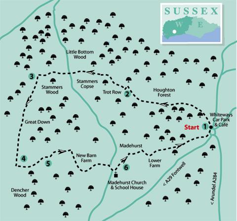
- So you don’t get lost: OS Explorer Map 121 plus a compass for general direction
Click here for a full-sized map of the Madehurst circular walk


Comments: Our rules
We want our comments to be a lively and valuable part of our community - a place where readers can debate and engage with the most important local issues. The ability to comment on our stories is a privilege, not a right, however, and that privilege may be withdrawn if it is abused or misused.
Please report any comments that break our rules.
Read the rules hereLast Updated:
Report this comment Cancel