
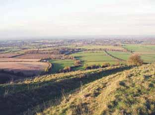
This downland walk by Eddie Start is on well-drained paths from Upper Kingston Lane to Edburton Hill, that offer the walker some relief from the winter Wealden mud. There are the expected long views across the county after a meandering valley approach and a return that strides past a prominent Iron Age site.
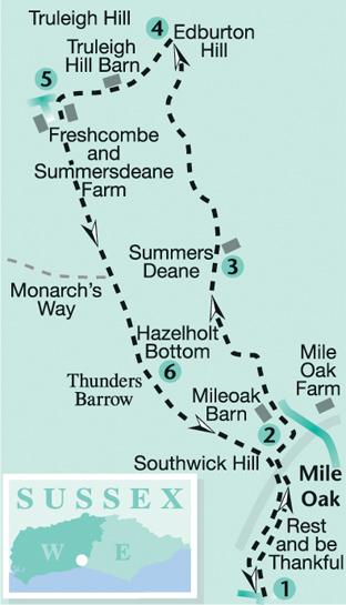
1 - From the short cul-de-sac at the top of Upper Kingston Lane walk out on to the open Downland on the restricted byway (red arrow). Climb northward for 300 yards, then veer half-right on the continuing track. On the way you will pass a National Trust sign on the right of the track, close to the edge of an area known as Rest And Be Thankful, and at the edge Southwick Hill, carry on past this. The traffic noise from the busy A27 road is a reminder that, after a long fight by conservationists, Southwick Hill was saved from excavation during the road’s development by the inclusion of a tunnel, now beneath the walker’s feet. The restricted byway climbs between downland scrub for a further one-third-of-a-mile and takes a half-left turn to arrive, in a further 300 yards, beside a second National Trust sign for Southwick Hill. Do not pass through the fence opening and metal gate ahead, but instead locate a squeeze stile in the fence off to the right.
2 - Pass through the stile on to open access land and descend to the quarter-right down the hillside, taking a line that passes between the two prominent power line pylons and through the scrub. On coming to a faint, narrow crossing path at the top of a bank, drop right, down the path to a wide, sunken chalky track, and turn left. Walk down the track for about 350 yards to draw alongside Mile Oak Farm and Barn, away to the right. On arriving beside a bridle gate on the right, next to a paddock, pass through and turn left on the enclosed footpath. Follow the path around the paddock edge, to arrive at a wider crossing track, just north of stables.
Turn left, following the restricted, valley bottom byway to a take a right turn in 100 yards and then climbing to a sweeping left turn in a further 400 yards. Continue ahead towards double metal gates in 200 yards at Hazelholt Bottom. Do not go through the gates but take the abrupt right turn. Keep to the slightly rising, wide track, as it continues up through Summers Deane for half-a-mile to a bridle gate, with a brick barn off to the right.
3 - Pass into the next meadow and follow the path line to the half-left around the flank of the hill, for one-third-of-a-mile, then descend towards a gate and a junction of paths on the valley floor. Go through the gate and turn right along the valley bottom. Follow the wide sweeping turns of the valley for nearly three-quarters-of-a-mile to arrive at a gate that finally climbs to give access to the crossing South Downs Way. Cross the track to take in the wide and extensive views across the Weald, with Edburton Hill off to the right.
4 - Return to the South Downs Way, turning right up the hillside as the trail winds its way up to the top of Truleigh Hill. Stay on the track as it passes the distinctive brick-built Truleigh Hill Barn at the top of the climb. Continue, passing a variety of dwellings, farm buildings and stables and the very prominent radio and telephone masts. Truleigh Hill was a Second World War radar site, monitoring the coast as part of the extensive and newly-developed radar technology; staff from the site were drawn from the RAF station in Shoreham. There was also a nuclear bunker, it is said, burrowed beneath the hilltop, that was de-commissioned in 1958.
The trail begins a slow descent on the wide track to a four-way path junction.
5 - Turn left on to the southward bridleway that leads towards Freshcombe and Summersdeane Farm. This is a three-mile-long bridleway that demands a brisk stride-out and it would be difficult to go the wrong way. There are wide views across the surrounding downland and out to the English Channel. The path passes to the left of the hilltop farm buildings and continues southward on a wide bridleway. After a mile the bridle-way is joined from the right by the Monarch’s Way, in the final stage of its long-distance trail from Worcester, once travelled by the man who would be king to catch a boat to France. The path maintains direction and begins a slow climb towards the landscape feature known as Thunders Barrow. Dating from the early Iron Age, the camp was inhabited over a long period, as the surrounding field systems testify. Romano and Saxon pottery has been excavated at the site.
6 - The path skirts around the edge of the main site and begins a sweep to the left, passing through a gate to continue between downland scrub. In a quarter-of-a-mile, pass through double metal gates on to the National Trust site on Southwick Hill.
Maintain direction on the wide bridleway, to finally arrive at the gate and fence opening we were at earlier at stage one of the walk. Go ahead on the track, soon re-entering the close downland scrub across the top of Southwick Hill. The path diverts to the half-right, after 300 yards, to begin the final descent, passing Rest And Be Thankful, to arrive back at the starting point of the walk in half-a-mile.
* Distance/Time: Seven miles taking three hours.
* By Car: Leave the A27 Old Shoreham Road at Kingston Buci, go north from the traffic lights on to Upper Kingston Lane. There is on-street parking at the top of the lane in a cul-de-sac. Start point Grid Reference: TQ238065.
* By Public Transport: For bus details visit www.traveline.info or call 0871 2002233. * What’s underfoot: Open Downland walking on well-drained bridleways, some easy climbs on well-graded paths. Possible with a baby backpack. Could be done with a baby buggy, but it would be a bumpy ride and you’d need to negotiate a squeeze stile and a slippery bank path.
* Thirsty Work: No refreshment stop on this walk – take a picnic to relax and enjoy the views.
* So you don’t get lost: OS Explorer maps 122, plus a compass for general direction.


Comments: Our rules
We want our comments to be a lively and valuable part of our community - a place where readers can debate and engage with the most important local issues. The ability to comment on our stories is a privilege, not a right, however, and that privilege may be withdrawn if it is abused or misused.
Please report any comments that break our rules.
Read the rules here