
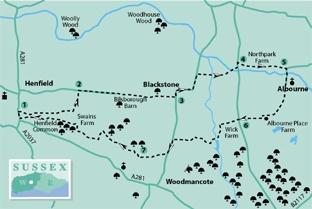
1 - In Henfield High Street locate The George Hotel and take an unsigned footpath across its car park. At the far side, with the Garden Suite of the community hall ahead, over a hedge, turn right along a twitten. In 200 yards, at a crossing track, turn left to a residential road. Turn right, towards Henfield Bowling Club. Keep right of the club building, passing allotments and entering scrub. Continue along a fence-enclosed footpath, coming to a house called Camellias after 250 yards.
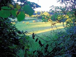
Take a few paces left and turn right, ignoring a left turn, continuing ahead along an enclosed path to a tree- bordered, rabbit-burrowed, meadow. Keep to the right edge, beside trees and bushes bowed with seasonal fruit. At the far side, follow the path through scrub (beware rabbit burrows) to a meadow. Climb to a footpath sign and turn left. Descend the field-edge path, crossing a plank bridge in scrub and joining a track leading to Furners Lane.
2 - Turn right along the metalled lane, crossing a track after a quarter-of- a-mile and continuing towards Bilsborough Barn. Pass left of cottages, along a grassy track to a hedge-enclosed path, going through a kissing gate and keeping direction for one third of a mile. Where the path continues ahead, note a sign on the left and cross a stile, turning right up a field-edge. In a few yards, at the top right field corner, cross a stile. Walk along a mown path, beside paddocks and a line of walnut trees, heavy with seasonal crop, to the right corner. Continue beside a tall, wooden fence, descending to Blackstone Lane.
3 - Turn left up the lane, going right in 100 yards, between the hamlet’s houses. In 300 yards, after passing clapperboard cottages, turn left on the road, passing more dwellings. In 300 yards, just after farm buildings on the right, and before a “Thank You” road sign, turn right, over a plank bridge and stile, into a meadow. Head slightly left towards trees, passing through a hedge opening and crossing a footbridge.
Continue up a field-edge to a corner gate, then take a half-left line to a paddock corner. Pass through a gate and go right through a second gate into a garden. Take a quarter-left line, heading for a prominent weeping willow tree at the far side and crossing to a minor road.
4 - Turn left up the road and in 75 yards go right over a stile, towards a small brick barn on the left. Turn right over a plank bridge, then go left, crossing a succession of wooden bridges, beneath scrub. The path ducks and weaves its way along a bank for a quarter of a mile, with streams left and right. On clearing the scrub, branch left to cross a field- corner stile at Northpark Farm. Walk to a surfaced track, with a children’s adventure park ahead, and turn right.
5 - At a minor road turn right, crossing the bridge above Cutler’s Brook – on its way to join the Adur. It is suggested that the name of Albourne, the parish through which we now pass, derives from “alder’s bourn”, referring to trees growing along the banks of the stream – bourn being the term for stream. Continue along the road, with a wooden causeway on the left. Opposite the village church go right up a bank through hedgerow and turn left. In a few yards, beside outbuildings, go left a few paces, then continue southward between banks and trees to a meadow. Maintain direction across the hilltop to a three-way sign and turn right. Follow the path west through a gate and along a field-edge, descending to Albourne Place Farm. With a large, open-fronted timber barn ahead, take a few paces left and turn right between buildings, climbing away from the farm. Pass a hilltop house of modern design, continuing to the roadside.
6 - Cross to the opposite track, descending to a left turn at Wick Farm. Walk between farm buildings and across a yard to draw alongside Oatfield Cottage. Go ahead through a small gate, going right on a bank with ponds on the left. After a few yards descend right to a track. Turn left along the track, veering left in a few yards and then right along a right field-edge. Follow the field-edge, passing through a metal kissing gate, beside a large oak. Keep to the hedgeline, with a cricket field on the left. At a minor road, cross to the opposite plank bridge and turn left.
Follow the enclosed path for 250 yards, passing around a gate and turning right along a field-edge. In 250 yards, at a three-way sign, maintain direction, descending between fields. Turn right, beside hedgerow. In 75 yards, at a path junction, turn left into woodland.
7 - Follow the path for 200 yards, with a high fence on the left, to plank bridges. Cross a track and walk beside paddock fencing for a quarter of a mile. As the fencing sweeps left, locate and take a less distinct path half-right into hedgerow, crossing a plank bridge. On emerging from the bushes turn left for 150 yards, crossing a stile on the right. Walk across a field to a left corner, entering the next field and going half-right to a hedge corner, turning left to a paddock in 75 yards. Cross to the opposite tree line, climbing to a drive. Turn right, passing a left turn in 75 yards and continuing for 50 yards to take a left turn into woodland, just before Pigeon Croft and Swain’s Farm. Follow the twisting path for one third of a mile, climbing to a residential road, on the north side of Henfield Common. Go left, in front of houses, for 250 yards. Where the access road branches left, continue ahead, making for a twitten leading to Henfield High Street. Turn right, to the starting point.
* Distance/Time: Six-and-a-half miles, taking three-and-a-quarter hours.
* By Car: Henfield is on the A281 Horsham road, car parks and roadside parking in the village. Start from beside The George Hotel in the High Street. Start point Grid Ref TQ215159.
* By Public Transport: You can get specific bus details from www.traveline.info, phone 0871 2002233. Bus stop close to start point in the High Street, Henfield, 150 yards north of The George Hotel.
* What’s underfoot: Mainly level Wealden walking, no steep ascents. Possible with a baby backpack, not possible with a baby buggy.
* Thirsty Work: A choice of pubs and teashops in the High Street, Henfield.
* So you don’t get lost: OS Explorer map 122, plus a compass for general direction.


Comments: Our rules
We want our comments to be a lively and valuable part of our community - a place where readers can debate and engage with the most important local issues. The ability to comment on our stories is a privilege, not a right, however, and that privilege may be withdrawn if it is abused or misused.
Please report any comments that break our rules.
Read the rules hereLast Updated:
Report this comment Cancel