
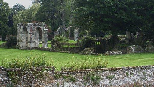
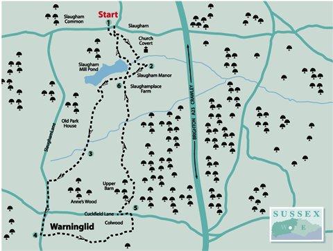
1 - From the forecourt of the church of St Mary in Slaugham pass through the lychgate into the churchyard, walking around the west end and passing the church porch on the south side. Keep to the brick path, taking the half-right turning that cuts across the churchyard, passing beneath an ancient yew tree. (Ignore the right turning from the signpost, near the porch.) Leave the church grounds through a gate, descending half-right in Church Covert, heading towards a gate at the lower edge. Follow the enclosed path, with the ruins of Slaugham Place on the left.
The original stately home was built for Sir Walter Covert in the early 17th century and partly demolished in the 18th century, the ruins being all that remains. Famously, the staircase from the building finished up as part of Lewes Town Hall, via the Star Inn.
Continue to the bottom of the path, towards trees and scrub, turning right, following a high fence skirting around the property. Cross right over a footbridge and turn left, passing an outbuilding. In a few yards, near the entrance to The Moat House and a sign indicating the path direction just taken, turn right up a bank through scrub to a surfaced drive. Turn right up the drive, passing Slaugham Manor, descending past houses and partly demolished outbuildings.
2 - From a footpath sign beside a parking area, keep direction for a few yards to a second sign and take the right branch along the southern edge of Slaugham Mill Pond. The pond is fed by headwaters of the River Ouse.
The enclosed path follows the shoreline of the pond for about 400 yards, with glimpses across the waters from angling pitches. Towards the end of the lake turn left over a stile, walking beside a fence to cross a double stile and plank bridge on the right.
Turn left, following the uphill path towards farm buildings. At the top of the climb cross to a farmyard, continuing ahead through a gap between barns. At the far side, take a few paces left, locate a continuing path, going right, behind outbuildings and descend beside paddock fencing to a junction of farm tracks.
3 - Go half-right, through a hedge opening, turning right along a field edge. Walk ahead for about 100 yards and, as the field-edge track veers right, bear slightly left, walking up the hill ahead on a trodden path. The ascent steepens for a short distance, passing across the hilltop to a kissing gate on to Slaugham Lane.
Turn left along the pavement for 350 yards, keeping safely to the road edge where necessary, to the crossroads in Warninglid. Cross to The Street – The Half Moon pub is on the left – and continue through the village.
In 1850 Alfred Lord Tennyson took a house in Warninglid but it did not suit the newly married poet, who was appointed Poet Laureate in that year, and after a brief stay he returned to the capital. In 200 yards, beside Herring Cottages on the left, turn left on to a public footpath.
4 - The path passes Herrings Barn, bearing right, crossing a stile and maintaining direction beside allotments. Keep ahead, crossing a stile on to a woodland path leading to a rustic metal kissing gate in 75 yards, and entering a sloping meadow.
Turn left along the field edge, climbing out from a shallow coombe to the left corner. Keep direction beneath rhododendron bushes, passing through kissing gates and along a left field-edge to Colwood Lane.
With a modern-style house opposite, turn left for a few yards, crossing a footbridge on the right leading into a clearing. Walk half-left to the top left corner, taking a few paces left beneath bushes; go right over a plank bridge and track and pass through a gate.
Continue along a right hedgeline for 200 yards, going through paddock gates on the way. On coming to a crossing track and path junction, turn left passing stables and descending to the roadside at Cuckfield Lane.
5 - Turn left along the grass verge for about 150 yards and, just after Grove Place, cross right over the road, with care, into a meadow.
Take a half-right line across the field, descending to the far right corner into woodland. Follow the path, which bears left over gullies, descending to a plank bridge and stile leading into a sloping meadow.
Walk ahead to a hedge corner in 200 yards and continue along a right hedgeline, maintaining direction. After about 200 yards, the hedgeline veers right. From this point, strike off quarter-left to a clump of trees surrounding ponds. Locate a path passing between two ponds. At the far side bear right on a trodden path to the field corner.
Pass through an opening, continuing along a right hedgeline and then climb a wide, tree-bordered path towards Slaughamplace Farm. Follow a driveway ahead, descending and bearing right to the point we were at earlier in the walk.
6 - Continue ahead to the parking area and turn left. The path passes across the end of Slaugham Mill Pond and at the far side descends for a few paces to arrive beside a low wall.
This is where the outlet from the pond was directed to power a corn mill in the 17th century, it possibly having some previous use as part of the local iron industry. Looking over the wall into the pool you will see below where the water has scoured the sandstone of the Hastings Beds.
Continue on a rising path, right and left, through the copse, then climb left through an avenue of trees towards the churchyard at Slaugham. Pass through the church grounds, retracing the route back to the start.
- Distance/Time: Four and a half miles taking two and a quarter hours
- By Car: Slaugham is on a minor road one mile south of Handcross, about half a mile west of the A23. Current restrictions on road access due to A23 roadworks. Follow diversion signs through Handcross and turn south on to Coos Lane, then turn left at crossroads to start point. Parking beside St Mary’s church in Slaugham. Start point Grid Ref: TQ257281.
- By Public Transport: Limited bus access requiring changes on some services. For travel details, visit www.traveline.info or call 0871 2002233
- What’s underfoot: High Weald walking with stiles and gates on good paths. A few short, easy climbs but no real difficulty. Possible with a baby backpack; not possible with a baby buggy.
- Thirsty Work: The Chequers pub at Slaugham and The Half Moon at Warninglid
- So you don’t get lost: OS Explorer map 134 plus a compass for general direction


Comments: Our rules
We want our comments to be a lively and valuable part of our community - a place where readers can debate and engage with the most important local issues. The ability to comment on our stories is a privilege, not a right, however, and that privilege may be withdrawn if it is abused or misused.
Please report any comments that break our rules.
Read the rules here