
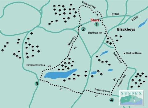
1 - Blackboys, in the parish of Framfield, has a long history. Its name has no racial connotation but rather is thought to originate from the local inhabitant’s occupation of charcoal burning in past centuries.
From the car park, return to the High Street (B2102) and cross to the finger post opposite. Go through the gate and follow the footpath between a fence and hedge.
Where the Vanguard Way (note VGW on waymarks) joins from the right, bear slightly left down to a wide track and turn left. In about 50 yards turn right to continue following the Vanguard Way, which goes along a path between fences.
The Vanguard Way is a long-distance route of about 66 miles from East Croydon to Newhaven, devised to celebrate the 15th anniversary, in 1980, of the Vanguards Rambling Club, who were so named after returning from a walk in the guard’s van of a crowded train.
On entering a wood the path soon goes steeply downhill to a farm track. Turn right and, in a few paces, go over a stile on the left. At this point the route leaves the Vanguard Way and joins the Wealdway (note WW on waymarks) heading south.
The Wealdway is a long- distance route of 80 miles from Gravesend in Kent to Eastbourne, devised by Ramblers’ Association members in the 1970s. Because of the poor state of rights-of-way between Uckfield and Eastbourne, publication of the route was delayed until 1981.
Follow the path uphill through the wood and then come to an unusual barrier in the form of a stile with a gate above. Cross this and follow the fence to cross a small footbridge.
Continue to follow the fence uphill to cross another stile with a gate above. Then continue on and through a wide gate to cross a road (B2102).
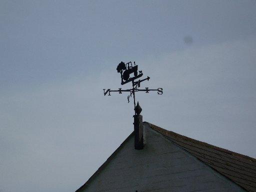
2 - Turn right and follow the roadside path for about 60 yards and then go through a gap in the hedge on the left to follow the field edge on the right. Cross a stile on the right by a white-painted cottage (look up to see an interesting wrought iron weather vane on the roof, pictured right) and turn left along the lane.
In about 70 yards, turn right across a field path with good views across the Low Weald towards the South Downs, which then goes along the edge of Newplace Wood and through a metal gate. Ignore a footpath on the left and continue to join a track towards Newplace Farm.
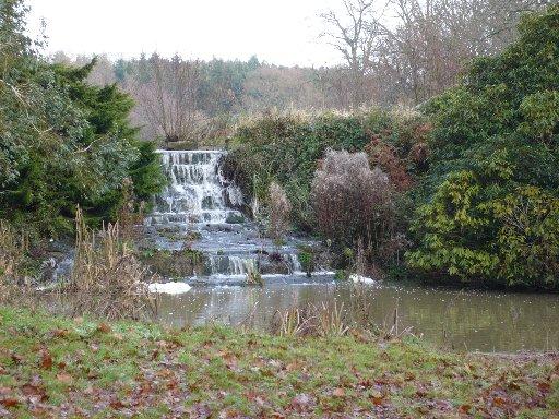
Pass to the right of the Tudor-style house, looking up at the Victorian crowns, with the dates AD 1878 and AD 1879, in the wall on the right. Just beyond, turn left on the driveway going downhill, past a lake and waterfalls on the left, to emerge in Pump Lane.
3 - Turn left, and in a few paces, go through a small gate on the left. Follow the field edge uphill and continue straight ahead aiming for the left-hand edge of a small wood.
Continue straight on, aiming a little to the right of a house with a white end, which can be seen ahead, to go through a wooden gate on the farther side of the field. Then go down steps and turn left along the roadside grass verge.
Immediately past the house with the white end, carefully cross this busy road (B2192) with fast-moving traffic then walk along Bushbury Lane. In a short distance the Wealdway goes off across fields to the right, but today’s walk continues along the lane for about 600 yards.
4 - Just before coming to houses on the left, turn left on a wide footpath, which is once more the Vanguard Way. Go over a stile and continue on this path for about 700 yards, passing through a metal gate on the way.
Nearing houses once more, go through a small wooden gate to the left of a large gate. In a few paces turn left along a road (Hollow Lane).
After about 250 yards, look to the right by a sign: Blackwell Farm. The house appears like a replica of an ancient building which has been dropped in a large field (possibly still work in progress).
Continue on down the road and, at the bottom of the hill, just before a sharp left-hand bend, turn right through a gap by a gate into woodland. Another VGW waymark here confirms the way.
Go straight ahead for about 40 yards, then turn left across a footbridge and up some steps. After a few paces, there is a seat on the right if a rest is desired; but there is less than half a mile to go now.
Follow the VGW waymarks through this woodland (Kiln Wood) to come to a road (B2192 again). Cross with care to the roadside path opposite and turn right.
5 - Here on the left is the Blackboys Inn, believed to be a 14th-century coaching inn. There are sizeable grounds around the pub, including a pond.
Take the next turning left past the pub into School Lane. In about 200 yards, turn left by a footpath sign into a twitten between houses.
After passing through a gate, follow the tarmac path around to the right with the recreation ground on the left. This leads back to John Dann Close and the car park.
- Distance/Time: Four miles/one and three quarter hours
- By Car: Recreation ground car park (free) in John Dann Close, off High Street, Blackboys (700 yards west of the B2102/2192 junction).
- By Public Transport: Buses from Lewes, Uckfield and Heathfield, then walk to the car park (see above). Timetable information from Traveline: www.traveline.info or 0871 2002233.
- What’s underfoot: Mostly good field paths and tracks but likely to be muddy in places if wet, especially at this time of the year. Possibly better if the ground is frozen or snow-covered.
- Thirsty Work: Blackboys Inn at point 5
- So you don’t get lost: OS Explorer map 123, plus a compass for general direction
Click here for a full-sized map of the Blackboys circular walk


Comments: Our rules
We want our comments to be a lively and valuable part of our community - a place where readers can debate and engage with the most important local issues. The ability to comment on our stories is a privilege, not a right, however, and that privilege may be withdrawn if it is abused or misused.
Please report any comments that break our rules.
Read the rules here