
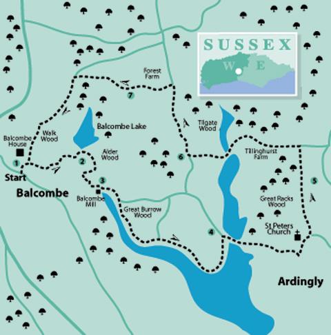
1 - In the village centre of Balcombe, a few paces from the Victory Hall, locate the junction of Bramble Hill and Haywards Heath Road, adjacent to the Half Moon Inn. Cross the busy junction towards the inn and walk down through the square, passing the Balcombe Stores.
In a short distance, turn right on the surfaced drive passing by cottages, continuing ahead towards gates and a footpath sign. Go through the middle kissing gate, bearing right and taking the track towards the village cricket field.
In 200 yards, at a right turning, divert left through an opening, following the left hedge around the cricket field. In 100 yards, beside a prominent holly bush, go left into tree cover and, at a path sign, turn left through a metal kissing gate along the top of a meadow, heading for a mid-field signpost.
From the sign turn right down a trodden field path towards a plank bridge and gate. Cross into the next field and turn half-left towards the corner, passing through a metal kissing gate to a surfaced farm track.
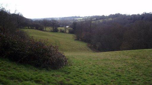
2 - Balcombe Lake, a tributary of the River Ouse, is on the left and worthy of a brief detour. Return to the gate and locate the opposite kissing gate, leading into a small field. Continue along the left edge beside Alder Wood, bearing right by about 15 yards. Descend a gully, cross a plank bridge then a stile. Keep direction in the next field, crossing a stile and descending to a minor road.
Turn right up the hill for 175 yards and, at the top, cross left to a bridleway, entering woodland. In a few paces bear left, turning right in 100 yards. Head to a metal bridle gate, pass through and turn left to go through a wooden kissing gate and descend winding steps to the roadside, close to Balcombe Mill.
3 - Turn right down the road, turning left beside the mill, crossing the causeway and climbing for 200 yards to an Ardingly Reservoir information board.
Go right through a gate and descend the path in Great Burrow Wood. The reservoir-side path follows the water’s edge southward for about one mile, ignoring a midway left turn, passing angling sites and information boards with details of wildlife and flora. The final bend in the path leads to a bridle gate beside a minor road.
4 - Turn right along the causeway path and, at the far side, continue up the roadside, passing a gate leading on to the continuing waterside bridleway. Climb the road for a further 150 yards and turn right down some steps, bearing left in woodland, coming to and crossing a double footbridge. Walk ahead a few paces and take a left fork in the path, climbing the steep bank beneath pine trees.
At the top of the climb, the path clears the tree cover, diverting left, continuing past a house to a residential road. Turn left up Church Lane to arrive beside the church of St Peter in Ardingly. Turn right for a few yards, branching left on a public footpath, signed as a private drive, and passing through a gate in 50 yards. Turn left along a metalled track beside the South of England Showground. In 50 yards turn right, following the service road beside the boundary fence for one third of a mile.
5 - On arriving at a junction of tracks walk ahead, bearing slightly left, towards a signed path leading into Great Racks Wood. After 200 yards the path clears the tree tunnel, continuing ahead towards the showground’s northern boundary and a three-way path sign.
Turn left down the surfaced drive to Tillinghurst Farm. Keep right of the farm buildings and then cross a farmyard, passing beneath trees into a sloping meadow. Continue down the right edge of a meadow, crossing intermediate stiles and entering a rhododendron-bordered gully.
Keep direction down the field, bearing left towards the bottom and passing through a gate. Turn left down a track and, in 75 yards, turn right over a long footbridge above the reservoir headwaters.
On the far side of the bridge, bear left for a few paces and then turn right on the trodden path climbing through Tilgate Wood – ignore the path leading left. Climb the winding path through the woods to arrive at Paddockhurst Lane after a quarter of a mile.
6 - Turn right along the quiet ridge-top road for half a mile, passing cottages and a high garden wall, to arrive beside the entrance to Forest Farm. Turn left on to the farm drive, bearing left and coming to a path junction after 175 yards.
Turn right towards farm buildings, following the path that crosses in front of the farmhouse. At the far side, pass beneath trees to a path junction. Cross the stile ahead, bearing left and coming to farm tracks in 125 yards.
Turn right along the left tree-line for about 125 yards. At a path sign, divert half-right across the meadow, heading for a stile at the lower side – a gnarled oak midway acts as a marker.
7 - Cross a stile descending through the woodland, bearing right at its lower end, crossing a bridge to a forest track.
Turn left along the track, soon crossing a stone bridge; ignore a right turning. Continue along the track for nearly half a mile and take a signed left turn, descending a bank, diverting right and crossing a long plank causeway above a boggy area. At the far side, cross a footbridge above a stream and climb steps in Walk Wood.
At a path junction turn right, climbing to clear the woods, continuing up the right edge of a meadow, passing Balcombe House, to a kissing gate and crossing track. Turn right up the track, back into the village.
- Distance/Time: Six and three quarter miles, taking three and a half hours
- By Car: Roadside parking in Balcombe village, close to Victory Hall. Start point grid ref: TQ309307
- By Public Transport: Bus service from Three Bridges to Balcombe Stores and Post Office. Trains to Balcombe; walk from station to village centre adds three quarters of a mile to walk. Travel details from www.traveline.info or call 0871 2002233.
- What’s underfoot: High Weald walking with plenty of rise and fall in woodland and along hilltop paths, some muddy sections beside Ardingly Reservoir, many stiles. Possible with a baby backpack but tough going; not possible with a baby buggy.
- Thirsty Work: Refreshments available at Half Moon Inn and Balcombe Tea Rooms
- So you don’t get lost: OS Explorer map 135 plus a compass for general direction
Click here for a full-sized map of the Balcombe circular walk


Comments: Our rules
We want our comments to be a lively and valuable part of our community - a place where readers can debate and engage with the most important local issues. The ability to comment on our stories is a privilege, not a right, however, and that privilege may be withdrawn if it is abused or misused.
Please report any comments that break our rules.
Read the rules here