
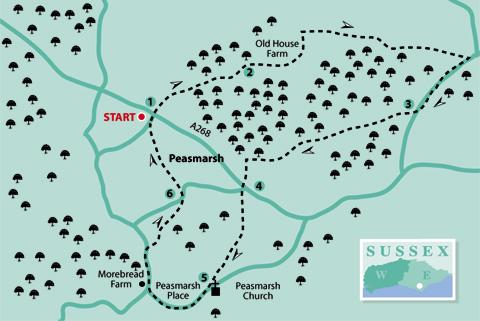
1 - From the lay-by in Tanhouse Lane, adjacent to the entrance of Jempson’s superstore, go to the main road (A268). For safety, cross at the traffic island to a footpath on the right of a board fence almost opposite.
Follow this path as it goes first by the fence and then by a stream on the left to a stile leading into a field. Go diagonally uphill (northeast) to another stile, which leads into a wood.
Follow the clear footpath signs through the wood until coming to a tarmac bridleway. Turn left and follow this until you come to Old House Farm; note the farmhouse on the left with its half tile-hung and half decorative brickwork walls.
2 - Continue on the bridleway, past a pond on the left, bearing slightly to the right, then downhill. Once over a stream, the route goes uphill and veers around to the left. On coming to a fingerpost at crossways, turn right on the grass track to continue on the bridleway.
At the end, go though a metal gate, past a fingerpost, then bear right to follow the footpath around the edge of the orchard with Iden Wood on the right. Go downhill, then uphill, to follow along the edge of an orchard on the right. On coming to a large field, cross diagonally right and aim towards an electricity pylon which will be seen on the horizon. Take the opportunity to pause and turn to admire the view to the north.
Nearing the field edge, a fingerpost indicates the exact spot to exit onto a narrow lane. Turn right along the lane for 600 yards and, just past Iden Boarding Kennels on the right, turn right by a metal gate along a clearly marked byway.
3 - This track, known as Malthouse Lane, appears to be undergoing some renovation work with the laying of a hard surface along much of its length. Continue along this for three-quarters of a mile until passing a recreation ground on the left. Follow the concrete access road around to the left to reach The Maltings housing estate.
Continue on the access road around to the left of the houses and green. Cross the Main Street (A268) at the traffic island on the left and go straight ahead through a twitten and residential car park to School Lane.
4 - Cross the road, turn left, and in a few paces turn right on a footpath with a sign: High Weald Landscape Trail (HWLT). This is a long-distance route covering 90 miles from Horsham to Rye, passing through the High Weald Area of Outstanding Natural Beauty. This walk covers only a small section here, and another small section farther on; more of this route will be included in future walks.
Follow the path that goes between houses and over a stile into a field. Continue straight ahead, over another stile and towards two gates which will be seen ahead. Go over a stile by the right-hand gate into a field, and ascend the hill diagonally to the right to go over another stile into the next field.
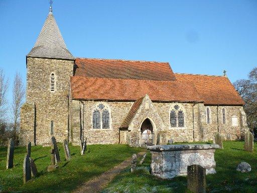
Continue in the same direction (southwest) towards a clump of trees with a pond on the right. From here, make for Peasmarsh Church which will be seen ahead. Go through a gate into the churchyard and around to the left of the building which is dedicated to St Peter and St Paul. Take a look inside, if open; the entrance will be found on the south side.
5 - From here, follow the path to the road and turn right along Church Lane. After about 500 yards, bear right at a road junction. Peasmarsh Place is on the right but it is rather hidden from view (no doubt, much to the owner’s delight).
Continue past the strangely-named Morebread Farm on the left. After a further 250 yards, where the road bears left, go over a stile on the right. Follow the footpath around the side of a pond on the left and then straight ahead (northeast) across the field into the next field.
Go across this field, continuing in the same direction, aiming towards chimney pots which can be seen just over the hill immediately ahead. This leads alongside a hedge on the left to a small gate. Go through to the road (School Lane again) and turn right.
6 - In 100 yards, where the road bends sharply right, go over a stile on the left and follow the footpath alongside a fence. This is the next section of the HWLT, encountered earlier. In spite of this being a well-used route, it is often very muddy in one particular field in which horses exercise.
If needing to avoid this, the only practical alternative is to continue down School Lane, and, almost opposite the village primary school, turn left through a twitten to the Main Street (A268). From here, turn left along the roadside footway to return to the lay-by in Tanhouse Lane.
If continuing along the HWLT, go over a stile, along the field edge and over another stile. Follow the field edges to go over yet another stile on the right, adjacent to Jempson’s car park.
Go downhill to Tanhouse Lane and turn right, crossing the entrance to Jempson’s superstore and restaurant to return to the lay-by. The Cock Inn is just at the top of the hill on the right.
Distance/Time: Five miles/two-and-a-half hours. Using the alternative route near the end will add a quarter of a mile.
By Car: Park in lay-by in Tanhouse Lane, Peasmarsh (adjacent to Jempson’s superstore entrance), off A268
By Public Transport: Buses (344) to Tanhouse Lane (Jempson’s superstore) from Northiam and Rye. Timetable information from Traveline: 0871 2002233 or www.traveline.info
What’s underfoot: Mostly good field and woodland paths but likely to be muddy in places, if there has been recent rain
Thirsty Work: The Cock Inn (near start/finish); The Horse And Cart, School Lane (near point 4); Jempson’s restaurant (near start/finish)
So you don’t get lost: OS Explorer Map 125 and a compass for general direction


Comments: Our rules
We want our comments to be a lively and valuable part of our community - a place where readers can debate and engage with the most important local issues. The ability to comment on our stories is a privilege, not a right, however, and that privilege may be withdrawn if it is abused or misused.
Please report any comments that break our rules.
Read the rules here