
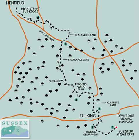
1 - From beside the Devil’s Dyke pub, look out on to the Weald from the viewing platform, a few yards north of the drop-off point, for the next part of our journey from the coast. This area was once referred to as the Wild Wood and was ventured into by earlier inhabitants, who dwelt in hilltop enclosures and drove their herds down into the forest to graze on autumnal fruits.
Take in the rise and fall of the terrain – Low Weald, High Weald, onward to the North Downs and Box Hill in the dim distance.
From the platform, head west, passing through the wood-en kissing gate on to the path that leads across an Iron Age embankment. Continue around the top of the deep coombe that plunges to the right.
At about the halfway point around the coombe bear right, away from the higher path, crossing a mid-way ditch, heading for a marker post (blue arrow) and passing through a bridle gate. Go ahead from the gate for a few paces and bear right on the grassy, terraced bridleway, taking a traversing descent around the Fulking Escarpment, bearing right to pass a seat and marker post.
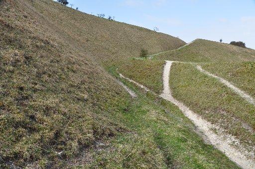
The track turns left around a grassy bluff, descending to a complex of ditches, tracks and embankments. These sunken tracks, known in Sussex as bostals, are the centuries-old trails that provided access to and from the hilltops, and have been eroded by human feet, animal hooves, frost and rain.
2 - Cross to the opposite bank and turn right – the gully path is also an option. In about 100 yards, the bank descends to a marker post and track junctions.
Turn full left along a recently cleared area to descend, bearing right, around a bank beside scrub to go through a bridle gate in a few yards (blue arrow).
Follow the sunken woodland track ahead to a crossing driveway and turn left to a minor road. Cross to the opposite grass verge and follow the northbound bridleway, between houses. In 300 yards the track bears left, coming to the entrance of Preston Nomads cricket ground and then Clappers Lane.
3 - Turn left along the lane, bearing right in a few yards. At the next bend, in 100 yards, cross right to an opening (there is a cottage on the left) and in 75 yards cross a stile on the right.
Climb beside the left hedgeline, then descend to cross a stile. Cross a narrow track and two more stiles, keeping direction down the next field, crossing mid-way stiles and a plank bridge and continuing to a hedge corner, with stables off to the right. From the hedge corner turn quarter-left to cross a stile and footbridge.
Turn left on a footpath (yellow arrow) along a field edge, with a stream down to the left on its way to the River Adur. Continue through an opening and along the next field edge to the distant field corner, crossing a stile beside a gate. Cross over the next field, walking half-left for 250 yards to a mid-fence stile.
4 - Turn right up a surfaced drive towards Perching Sands Farm. Keep to the concrete track, pass through a five-bar gate (yellow arrow) and across the front of the farmhouse, veering left towards a facing double garage. Skirt right on the footpath around the farm development and continue northward to a left turn in 200 yards.
Go left on the field-centre track towards the isolated dwelling of Nettledown. Walk past the first entrance to the house and in 100 yards come to a five-way path sign. Turn right, almost an about-turn, on to the signed bridleway (ignore the footpath going right), around the house boundary and enter woodland in a northerly direction.
In a quarter of a mile the bridleway takes a left turn over a footbridge, coming to a four-way sign beside a bridge. Go right on either the northbound bridleway or footpath (they merge later) and arrive at Bramlands Lane.
Walk ahead up the quiet lane for half a mile to the Horn Lane junction, cross to the opposite footpath and turn right along the pavement. On coming to the busy A281 road, cross right, following the pavement for 100 yards, crossing left, with care, to Blackstone Lane.
5 - Walk along the lane for a quarter of a mile and turn left through a metal gate, continuing along the right hedgeline. In 250 yards go through a deer gate, descending the next meadow to the opposite hedgeline. Turn right for 75 yards and at a three-way sign go left into woodland, beside a high wire fence on the left.
In 250 yards cross plank bridges, pass through a deer gate, cross a track and continue ahead, beside paddock fencing, for a quarter of a mile. Where the fence bears left, take a right branch through trees, crossing a bridge to a footpath.
Turn left for 150 yards on the enclosed path, crossing a stile in the right fence. Go ahead across the meadow to the far side, aiming for a bridge about 25 yards from the left corner. Keep direction across the next two fields, climbing out to a surfaced track.
6 - Turn left for 75 yards, skirt right around a sports pavilion and take a line across the sports field, passing between cricket and football pitches.
Keep right of a copse, continuing to the left corner, and pass through woodland on the main, trodden path and, on clearing the trees, continue ahead, taking any one of the several paths, across Henfield Common.
When close to the far western side of the Common, turn right around a pole barrier, and in a few yards turn left along a track, leading to a twitten and Henfield High Street. Turn right for bus stops or pre-arranged pick-ups.
Distance/Time: Six and a half miles, taking three and a quarter hours
By Car: Drop-off at Devil’s Dyke National Trust car park, beside pub. Pick-up in Henfield High Street, car park is signposted and is next to the library. Start point grid ref: TQ259111
By Public Transport: Number 77 bus from Brighton centre to Devil’s Dyke, call 01273 886200 for times. Return bus service no 17 to Brighton or Horsham from Henfield High Street. All of the walks on this south/north traverse can be accessed by public transport. Visit www.traveline.info or call 0871 2002233
What’s underfoot: Steep descents from the South Downs and Wealden bridleways and footpaths with some stiles. Possible with a baby backpack; not possible with an off-road baby buggy
Thirsty Work: Refreshments available at Devil’s Dyke pub and pubs and cafes in Henfield
So you don’t get lost: OS Explorer Map 122 plus a compass for general direction
Click here for a full-sized map of the Devil’s Dyke to Henfield walk


Comments: Our rules
We want our comments to be a lively and valuable part of our community - a place where readers can debate and engage with the most important local issues. The ability to comment on our stories is a privilege, not a right, however, and that privilege may be withdrawn if it is abused or misused.
Please report any comments that break our rules.
Read the rules here