
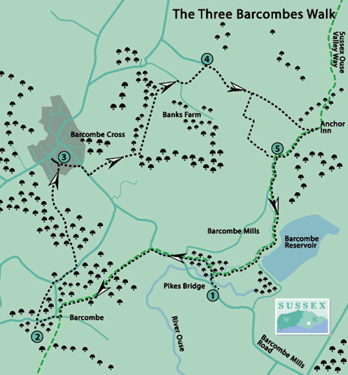
1 - If arriving by bus, walk along Barcombe Mills Road for half a mile to the car park on the right.
From the car park entrance, follow a footpath to the left (north-west) running parallel to the road. This is part of the Sussex Ouse Valley Way, a 42-mile route following the river valley from its source near Lower Beeding to the coast at Seaford Bay.
Turn right on a road, crossing Pikes Bridge, then over a second bridge. On crossing the third bridge, see the List of Tolls – however, no charge for pedestrians! Turn left by a marker post, along the old road.
At the road junction turn right and just beyond a few houses, look right to see the track of the dismantled railway from Lewes to Uckfield. (There are moves to re-open this.) On the left is the old station building.
It is advisable to cross the road here to avoid crossing at a sharp bend. In 150 yards, turn left over a stile and along the lower field edge, aiming for the left-hand stile of two seen ahead.
Continue over the stile to cross a footbridge, through an orchard and over another footbridge. Cross the field ahead to a fingerpost to the left of a line of trees, then bear right across the next field and through a hand gate. Turn left along a twitten until reaching a farm drive. From here there is a good view of the South Downs.
Turn right and in a short distance facing a brick wall, turn left along Church Road. In 150 yards, turn left along the driveway to the Parish Church. Notice two barns on the left: one built of wood with a tiled roof and an open round one with a thatched roof.
2 - The church building, the oldest part of which was built in the 11th century, is distinguished by its spire of Sussex oak shingles. Take a look inside, if open, for the best view of the stained-glass windows.
Return along the driveway and cross the road to go through a kissing-gate opposite. Note the GMT waymark, not a reminder that we have now reverted to Greenwich Mean Time but indicating that our route to Barcombe Cross follows the Greenwich Meridian Trail. This was created in 2009 for the 125th anniversary of the Greenwich Meridian, and closely follows it for 273 miles from Peacehaven to East Yorkshire.
Follow the field edge for 350 yards, crossing a stile and ignoring another footpath on the left. Go through a kissing-gate and turn right on the road. Almost immediately, turn left along Church Road.
In 250 yards, turn left to cross a stile to follow the footpath over two more stiles, then just to the left of poles towards a fingerpost.
Follow the footpath into the wood and cross the old railway track from Lewes to East Grinstead. Continue uphill and along the woodland edge to the left before turning right into a field by a fingerpost.
Follow the left-hand field edge towards houses and through a twitten. Ignore another footpath on the left and come to an estate road.
3 - We have now arrived at Barcombe Cross. If desiring to go into the village and/or The Royal Oak, turn left. Then retrace the route.
Otherwise, turn right along a twitten into Mongers Mead estate. Go straight ahead and cross Barcombe Mills Road; then turn right along the footway to where it ends.
Here, turn left into the Village Hall entrance and go through the car park – a fingerpost points the way. Then turn left on a grass footpath following the right-hand field edge and through or around two metal gates.
The route continues to the right of a reservoir, through a squeeze stile and over a footbridge. Then turn left following the footpath in a straight line to the right of a stream for 600 yards.
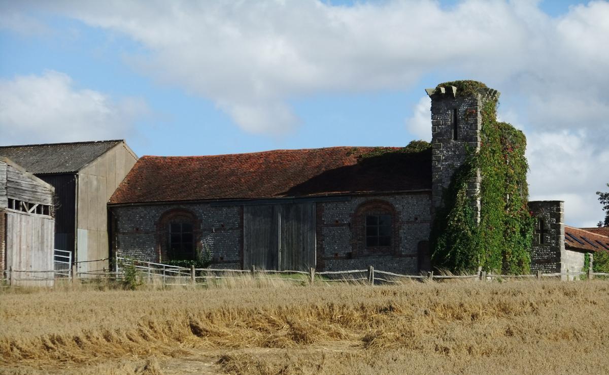
Go through a squeeze stile by a metal gate, bearing right uphill. Look to the right to see an old stone barn at Banks Farm.
Continue through a squeeze stile, crossing a drive and over a footbridge by a fingerpost slightly to the left. Follow the footpath up steps, through another squeeze stile, then follow the left-hand field edge and through yet another squeeze stile.
4 - Turn right along Anchor Lane for 550 yards. There are now two options from here to point 5.
If going to The Anchor Inn (the slightly longer route) continue along the lane for 700 yards to the Inn. From here, go across the lane and through a kissing-gate. Follow the Sussex Ouse Valley Way south-west along the riverside to a fingerpost at point 5.
Otherwise, turn right by a hidden fingerpost to follow the footpath which zigzags along the right-hand field edge, then through a gap to follow the left-hand field edge. Bear right at the end to cross a stile and the track of the dismantled railway. Go through a hand gate towards a fingerpost.
5 - Go through a hand gate onto a tarmac path and in 125 yards go over a farm bridge on the left. Turn right to follow the riverside for three quarters of a mile, crossing two footbridges to arrive at a neat grass area with seating, suitable for a picnic.
Go through a stile, turn left and retrace the route to the car park. For bus users, retrace the route to the main road.
- Distance/Time: Five miles/two and a half hours, an extra mile for bus users and an extra quarter of a mile if going to The Anchor Inn
- By Car: Use car park (free) half a mile along Barcombe Mills Road, north-west of A26 between Lewes and Uckfield
- By Public Transport: Buses (29) from Lewes and Uckfield, alight at Barcombe Mills Road. Timetable information from Traveline, call 0871 200 2233 or visit www.traveline.info
- What’s underfoot: Mostly good level field and riverside paths which may be muddy after rain, short distances on minor roads
- Thirsty Work: The Royal Oak, Barcombe Cross; The Anchor Inn, between points 4 & 5; The Cock Inn, just off-route (south-west) along the A26
- So you don’t get lost: OS Explorer Map 122 and Landranger 198, also a compass for general direction
Click here for a full-sized map of the Barcombe circular walk


Comments: Our rules
We want our comments to be a lively and valuable part of our community - a place where readers can debate and engage with the most important local issues. The ability to comment on our stories is a privilege, not a right, however, and that privilege may be withdrawn if it is abused or misused.
Please report any comments that break our rules.
Read the rules here