
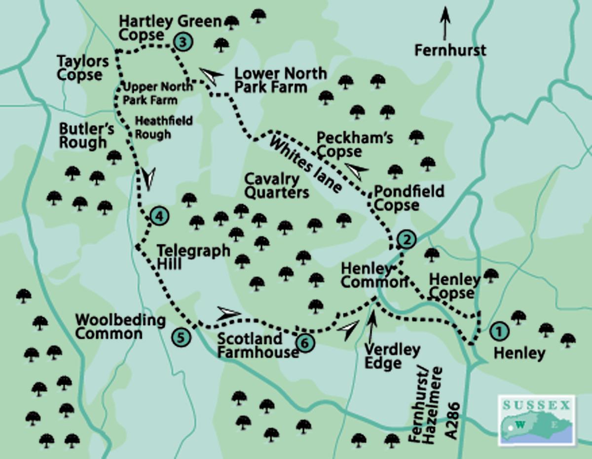
1 - From beside the Duke Of Cumberland pub in Henley, head northwards down the narrow, steep road. This was once the main road and, it is said, has Roman origins, although it is likely to have been a track for hundreds of years, long before the men in togas arrived.
Walk down the hill for 200 yards, turning left over a footbridge to a footpath (yellow arrow) into woodland. In a few paces branch left, climbing beside a chestnut paling fence to the top of a slope and there turning right.
The path bears left, beside a steep bank, through Henley Copse, making a gradual descent. In 400 yards, take a right turn (yellow arrow) and in 50 yards bear left, still in woodland on Henley Common.
In 300 yards, at a crossing footpath, turn right for 75 yards to the roadside and cross with care to the opposite single track road.
2 - Walk along the road, passing cottages, dipping right and climbing out (ignore crossing footpaths), continuing for a quarter of a mile to a left turn next to Pondtail Copse.
Turn left on the quiet farm access drive and bridleway, designated as Whites Lane, with Peckham’s Copse on the right and, rising left, the wooded hillside of Cavalry Quarters.
In half a mile the track takes left then right turns, passing Lower North Park Farm and climbing to a four-way path junction.
Turn left down the bridleway, turning right to a stream bridge crossing and in a few paces climbing left, towards Upper North Park Farm.
Just before the farm gate, turn right on to an enclosed bridleway along a left field edge. In 250 yards, descend beneath trees to a junction of wide woodland tracks, with Hartley Green Copse ahead.
3 - Turn left for 300 yards on the wide track, with tall mature trees on the right and a younger plantation on the left. At a clearing, bisected by a north-south power cable corridor, cross to the opposite footpath, entering close woodland.
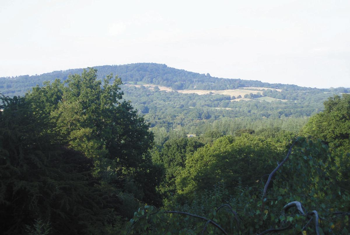
In 150 yards, at a crossing footpath adjacent to Taylors Copse, turn left. In 100 yards, clear the enclosing trees, coming to the edge of a large expanse of more recently cleared forest at Heathfield Rough, with mature trees on the right.
Keep to the right edge of the rough, following an indistinct and lumpy path south for about a quarter of a mile, finally descending to a junction of tracks, with closer woodland ahead.
Go forward on a narrower path, bordered by Butler’s Rough (he probably was) and Ward Copse. The path can be muddy in places, indicating that we are leaving the Wealden clay, in preparation for an ascent of the lower greensand stratum. Care is required at a few points along the way, where the path has eroded into a deeper gully.
In a quarter of a mile, the path arrives at a clearing with a footbridge; cross and climb the opposite steep slope, there are power cables overhead. In about 50 yards at a marker post, turn left (yellow arrow), soon bearing right and climbing steeply through West Copse.
4 - On arriving at a crossing forest track turn right, passing around a gate and walking ahead for about 75 yards to a path sign – there is an isolated dwelling on the right. Turn left into the undergrowth – the ascent of Telegraph Hill is about to take on a more challenging and seasonally colourful aspect.
In a few paces take the right, of two indistinct paths through the foliage to be confronted by a steep bank, climb this with care, making use of the rope handrail for security.
In a short distance the path comes to a less-steep clearing and a stunning display of rowan trees climbing the slopes, the red berries making a colourful, seasonal contrast to the surrounding greenery.
Continue the steep climb, beneath trees, coming to a signpost and continuing on the path to a three-way sign as the gradient levels. Keep going ahead in the hilltop woodland to a third signpost and crossing track; there turn right.
Follow the track south-eastward, with Woolbeding Common on the right. After nearly half a mile, and 300 yards after a right turn, which you ignore, take a left turning – there is a partially-obscured marker post on the left in rhododendron bushes.
5 - Climb a slope for 50 yards, turning right on to a shallow gully path to arrive at the isolated Scotland Farmhouse. Ahead is a magnificent example of a Wealden barn, constructed from local sandstone, neatly and uniformly laid and presenting a fine example of local craftsmanship, by unknown hands, which has probably stood and weathered for generations.
With the barn 50 yards ahead, turn left, crossing a stile, and take a half-right line across the hilltop meadow, passing a midway marker post and heading for opposite woodland. Bear right on a track, with the trees of Northpark Copse on the left.
6 - In 350 yards, turn left into woodland. In a few yards take a right fork and in a further few yards, a second right fork. The gully path descends, bearing right, and is joined by other tracks, arriving beside secluded houses after one-third of a mile, 75 yards before the roadside.
Turn sharply right up a gravel driveway, pass across the front of the house called Verdley Edge, aiming for a path left of a garage. Climb a gully path for 300 yards to a signpost and take the left turn. Descend beneath trees to the roadside, crossing with great care to the opposite road.
Walk down the narrow road for 200 yards, turning left down the hill in Henley.
In a short distance arrive back at The Duke Of Cumberland pub. There is one thing left to do: before anything else passes your lips, sample the fare at this idyllic pub and setting. Your life as a Sussex ambler will be fulfilled.
Distance/Time: Six and a quarter miles taking three and a quarter hours
By Car: On-street parking in Henley, close to the village pub. Henley is approximately midway and east of the A286, on the Midhurst to Haslemere road, there is a very tight turning from the main road at the southern end. Start point GR SU894257
By Public Transport: Bus service from Chichester to Midhurst (Stagecoach South 60), change to Fernhurst/Haslemere bus (Stagecoach South 70), alight at Henley stop and walk down minor road to start point, see stage six of walk details. Travel details from www.traveline.info, call 0871 2002233
What’s underfoot: Hilly country with stiles and gates, some very steep climbs and narrow, irregular paths beside stream beds and through undergrowth. Not recommended with a baby backpack, not possible with an off-road baby buggy
Thirsty Work: The Duke Of Cumberland pub in Henley – it has to be done
So you don’t get lost: OS Explorer Map 133, plus a compass for general direction


Comments: Our rules
We want our comments to be a lively and valuable part of our community - a place where readers can debate and engage with the most important local issues. The ability to comment on our stories is a privilege, not a right, however, and that privilege may be withdrawn if it is abused or misused.
Please report any comments that break our rules.
Read the rules here