
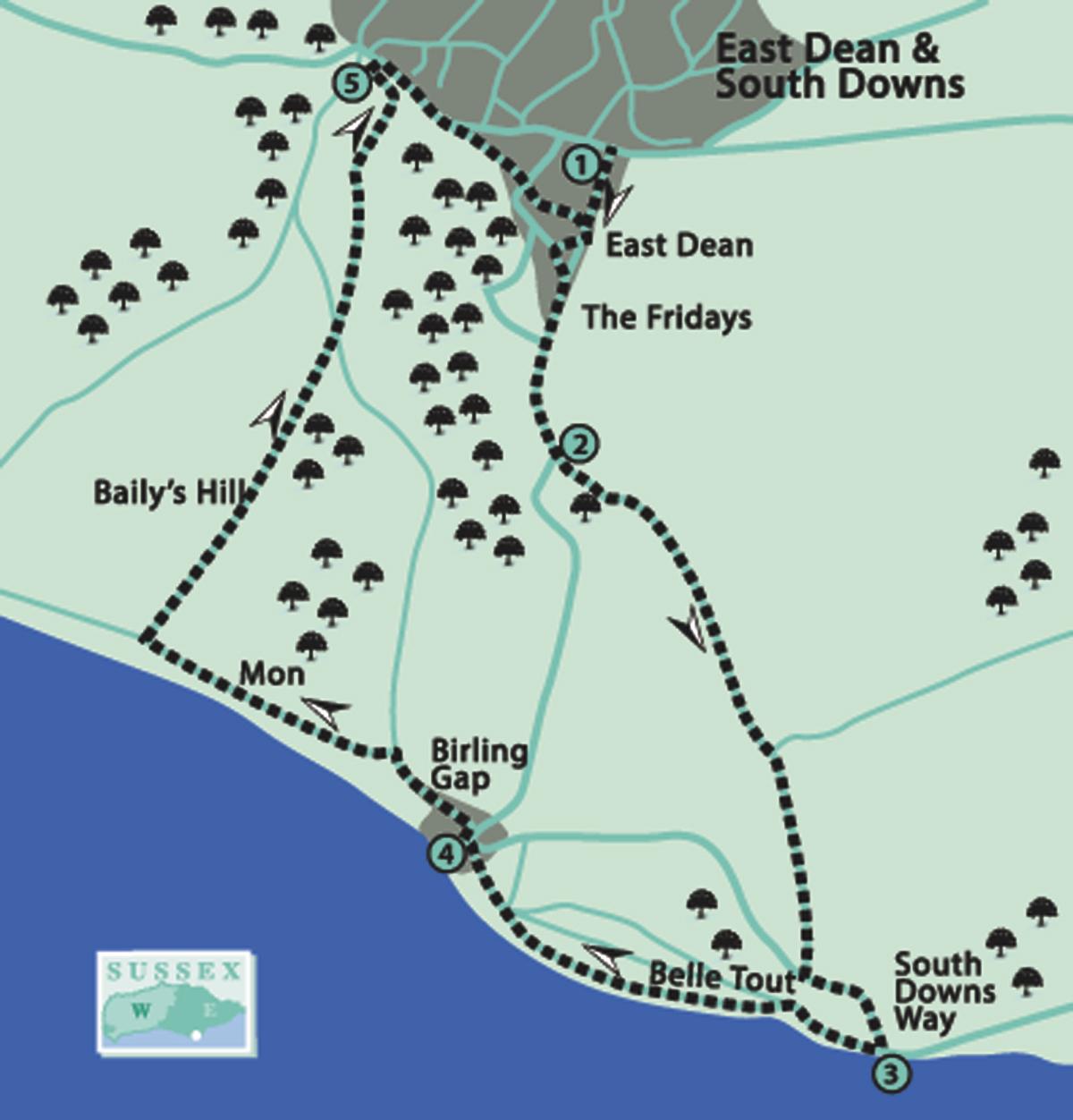
1 - From the bus stops, go along Gilberts Drive (southwards) for 300 yards, past the Village Hall entrance; or from the Village Hall car park, go out to Gilberts Drive and turn right for 60 yards.
Turn right through a gate into the churchyard. The church building is dedicated to St Simon and St Jude, the oldest part of which is the 11th-century tower. The present nave was added in the 12th century and the chancel in the early 13th century. The nave was extended west in 1885 to include the bridge and organ, and again in 1961 to 62.
Go through the gate near the entrance and turn left along Lower Street. Turn right into Gilberts Drive and by houses named The Fridays. Continue along by the road on a wide grass verge for 550 yards.
2 - At a sharp right-hand bend, cross the road (there is good visibility) and go along the drive straight ahead. Immediately before the entrance to Birling Manor, turn left through a gate by a bridleway fingerpost. Turn right and, passing to the left of a cottage, go through another gate, then follow the bridleway along the valley (not the one uphill).
After passing through a gate, follow the flint stone wall on the right. The shape of a couple of trees indicates the prevailing wind direction! Where the wall turns abruptly to the right, go through another gate and continue direction.
After going through the next gate, bear right to join and follow a concrete drive; there is a wide grass verge on the left, if preferred. The famous Belle Tout lighthouse is to be seen directly ahead.
On reaching a road, cross on to a grass footpath for 40 yards, then turn left along a path which runs parallel to the road towards the sea for 350 yards. Just after crossing an access drive, come to a sharp left-hand bend where there is a small car park; pause to view the information board.
3 - Follow the footpath to the right which rises steeply towards the Belle Tout lighthouse. Take care to heed the cliff edge warning signs. The route now follows the South Downs Way (SDW), which is a national trail of about 100 miles from Eastbourne to Winchester. Look for the acorn signs on waymarks.
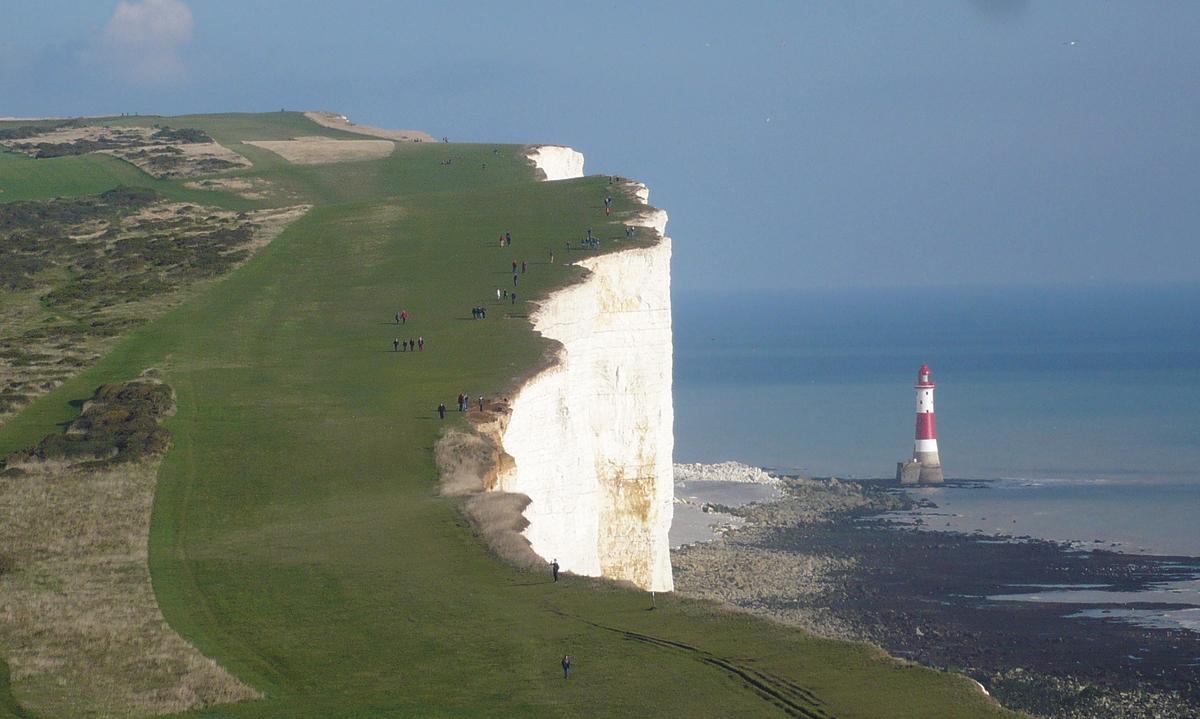
Pause on the way, turning to see Beachy Head with its famous red and white lighthouse (recently re-painted) at the foot of the cliffs. In 1902 this replaced Belle Tout, now a private dwelling. The latter was moved inland by about 20 yards in 1999 to prevent it falling into the sea because of the crumbling cliff edge.
On approaching Belle Tout, the footpath veers to the right, crossing the access drive once more, around the building as marker posts indicate. Continue for half a mile and, where the path veers left towards the sea, turn right by a marker post. Follow the path downhill towards houses with views of the chalk cliffs, known as the Seven Sisters.
4 - At the bottom is Birling Gap. Go through the car park, where there is a cafe, picnic area and toilets. Then go over a stone stile to the right of the toilets and turn left on a stony track uphill, with houses on the right.
Go through a gap beside a five-bar gate and turn right as a waymark indicates. In a few paces, turn left at an SDW fingerpost and through a kissing-gate. Continue ahead through the next kissing- gate to enter Crowlink open downland.
Follow the SDW as it descends steeply into a valley. Then, as the ground rises again, a monument will be seen to the right. This was erected, and the land given to the National Trust, in memory of some men killed in action during the First World War (the inscription is rather difficult to decipher).
Continue to the crest of the hill, then turn right to leave the SDW along a clear grass path. This is open access land (shown as Bailey’s Hill on the Explorer map), so follow my directions carefully as there are no waymarks for the next mile.
In about 250 yards, go over a stile into a very large field and stay on the highest ground straight ahead, keeping to the left of a wooded hollow. Go through a kissing-gate halfway along the farther end of the field.
Bear slightly left (north) to go across the next field and through a bridle gate at the left-hand end of a flint stone wall. Continue along the left-hand field edge then, near the end, turn left through a kissing-gate, followed by another, into Friston churchyard.
5 - The church building dedicated to St Mary the Virgin (the oldest part of which is the nave dating from about 1050) has a squat tower similar to the one at East Dean. Bus users now have the option to shorten the walk by leaving through the main gate and turning right to the main road.
Otherwise, exit the church yard via a stone stile and turn right along the roadside footway. In a short distance, this continues as an enclosed tarmac path away from the road.
At the bottom, pass through a barrier into Upper Street. Cross slightly to the right, down to the village green, war mem-orial and Tiger Inn. Go to the left-hand corner (east) to return to the car park, and via Gilberts Drive to the bus stops.
Distance/Time: Five and a half miles/two and a half hours; slightly longer for bus users, but with a shorter option.
By Car: Car park (free) adjacent to East Dean Village Hall off Gilberts Drive, south of A259.
By Public Transport: Buses 12/12A from Brighton and Eastbourne (frequent service), alight at East Dean. Timetable information from Traveline: 0871 200 2233; www.traveline.info
What’s underfoot: Mainly good downland paths with a few steep ascents and descents, which can be slippery when wet; very few stiles.
Thirsty Work: The Tiger Inn (near start/finish); National Trust cafe at Birling Gap (point 4).
So you don’t get lost: OS Explorer 123 or Landranger 199. A compass would be useful for general direction.


Comments: Our rules
We want our comments to be a lively and valuable part of our community - a place where readers can debate and engage with the most important local issues. The ability to comment on our stories is a privilege, not a right, however, and that privilege may be withdrawn if it is abused or misused.
Please report any comments that break our rules.
Read the rules here