
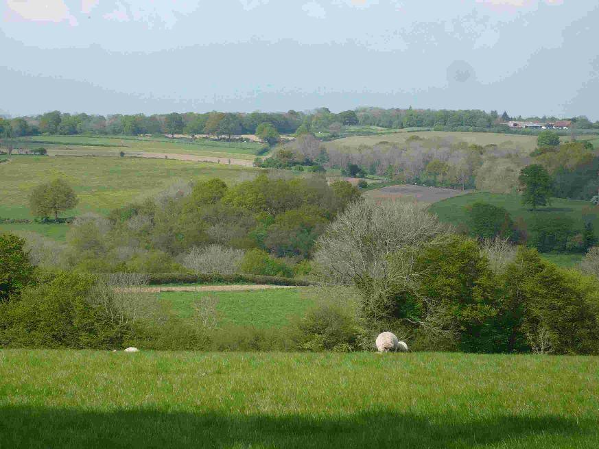
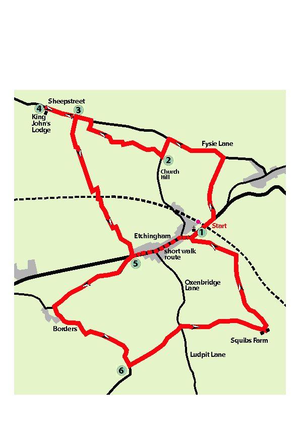
THE parish of Etchingham lies in the picturesque Rother valley near the Kent border. John Harmer offers a choice of walks, with an optional visit to a house with a medieval legend From the station, turn left at the main road.
Follow the footway over two footbridges and, at a fingerpost, go over a stile and down a few steps.
Bear right across the field, cross a footbridge; then bear right along by the river to cross another footbridge. Veer diagonally left to the the gate in the left-hand corner of the field, and forward to Fysie Lane.
Turn left along the lane and, in about half a mile at a junction, turn left into Church Hill. Go downhill for 200 yards, then over a stile.
On the footpath follow waymarks where the path zig-zags through woodland. Reach a hand gate, and cross a farm track to the footpath opposite, then bears left.
In about 100 yards, there is a pond on the left and, where the path divides, keep left. In a further 100 yards, ignore a fingerpost indicating that the right-of-way turns left into a field; as our route turns right on a path through woodland with permissive access.
In a short distance, where the path divides, bear left. This bears left again in a westerly direction through saplings and scrub. On entering more mature woodland, go down in a dip and up again.
Turn right by a sign indicating permissive access; Follow the path. There are a couple of seats here; also look out for the tortoise. On coming to Sheepstreet Lane, turn left.
In about 250 yards there is a wide farm track on the left. For the optional extra, continue along Sheepstreet Lane for another 350 yards from where there is an excellent view across the Limden valley on the right.
A sign indicates the entrance to King John’s Lodge; an ivy-clad Jacobeean house. There is a legend that King John II of France was held hostage here in the 14th century.
The garden, nursery and shop are open to the public (closed on Tuesdays); also for the National Gardens Scheme charity on Sunday 22 June. Return along Sheepstreet Lane to point 3.
Otherwise, turn along the farm track and after about 350 yards, near a shed in the field on the right, turn left by a waymark into the wood. In a few paces, turn right by another waymark, continuing on the footpath downhill.
Go over a stile and continue along the right-hand field edge, following around to the left at the bottom of the field. Then turn right, crossing two footbridges over the River Rother. Veer right across the next field to cross the railway with a stile on either side.
Turn left, over another stile, turning right along the field edge. Go through a gate on the right and turn left along the path uphill. At a fingerpost, turn left on the official diversion. At a waymark, turn right, continuing on a track to cross the main road.
For the shorter walk, turn left along the footway, through the village, returning to car, bus stop or rail station. See also last paragraph.
To continue the longer walk, go along Borders Lane for three quarters of a mile. Turn left over a hidden stile just before the driveway to Borders, house and oasts. Go down the left-hand field edge, then over a footbridge on the left.
Turn right along the field edge and through a field gate into the next field.Veer left to go through a gateway, then forward to cross a bridge over the River Dudwell.
Continue up the left-hand field edge and through a gate with a waymark on the post. Go across the field, through another gate and turn right uphill to go through a gap into the next field.
Veer left to a gate at the top leading straight through the farmyard. Follow the driveway out to Fontridge Lane.
Turn left for half a mile to the junction with Ludpit Lane and Oxenbridge Lane. Cross over to the track leading to Squibs Farm. This is a private road, but a public footpath.
In 1,100 yard at crossways, turn left towards houses; going to the right, then left along the top field edge. At the end, veer right to go through a broken gate into a wood.Follow the path and go over a stile to the bottom right-hand corner of the field to go over another stile.
Bear left, uphill to the right of a barn, but left of a house. Go over a stile, cross a track, and over another stile.
Bear right down the field, through a gateway, and towards houses. Go over a bridge and then to the right of Stores Cottage to the main road.
Cross to the play area, entering by the gate to the left, where there are seats and a picnic area. A small gate leads to the Parish Church. Leave by the main gate and turn left for the rail station and bus stops.


Comments: Our rules
We want our comments to be a lively and valuable part of our community - a place where readers can debate and engage with the most important local issues. The ability to comment on our stories is a privilege, not a right, however, and that privilege may be withdrawn if it is abused or misused.
Please report any comments that break our rules.
Read the rules here