
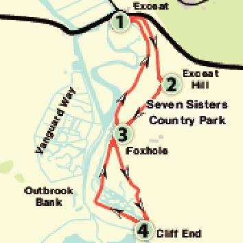
1. Start in the car park of the Seven Sisters Country Park, on the southern side of the A259 at Exceat.
Facing the car park entrance go through a gate on your right.
There are several paths ahead but try to keep left to cross a concrete track near the A259.
Beyond this aim for a gate in the fence line about 40 yards ahead higher up which should be indicated as the South Downs Way (SDW).
Begin a climb upwards, arcing right across the hill initially parallel with the A259 then branching away from it to the right.
In 200 yards at a Y-junction marked by a small directional post, take the right path following the SDW.
After a while the route begins to level off. In a further 200 yards a gate and fence line come into view.
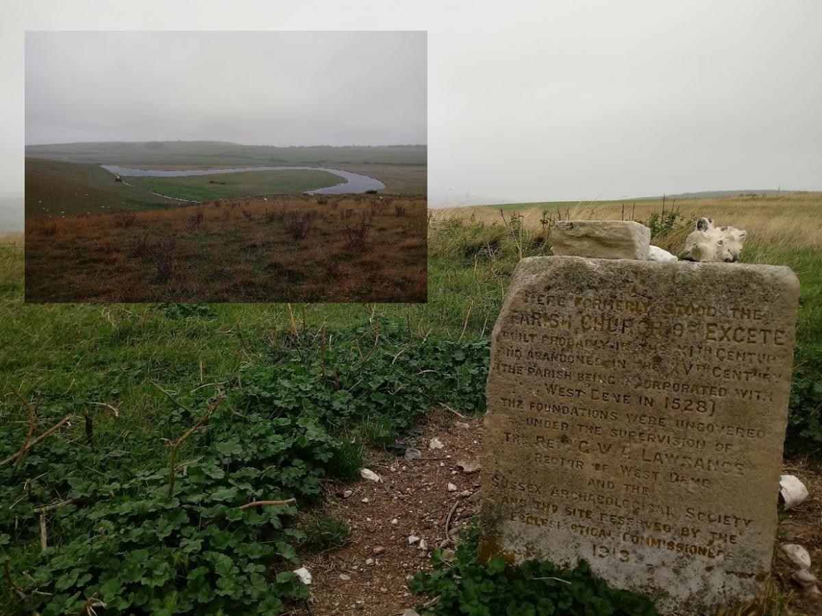
2. Just short of this over to the left is the interesting historical feature of this walk.
About 50 yards before the gate turn left upwards and in about 50 yards from the path you should find in the grass a small stone tablet inscribed with text on one side.
It is fine to deviate from the footpath here as this area is classified as Open Access Land.
This monument indicates the approximate location of the old parish church of Exceat abandoned in the 1400s.
The stone was probably placed here in 1913 by the local ecclesiastical bodies and Sussex Archaeological Society who at this time were researching the church’s remains.
Nothing appears to remain of the church above ground however the amazing views out to sea surely cannot have changed much.
To continue make your way through the gate ahead and follow the SDW downhill to the right in the general direction of the river estuary below.
Two short marker posts line the way as you descend.
3. At the bottom of the descent go through a gate to join a path below.
Turn left to go through another gate, still on the SDW.
In 100 yards at a Y-junction take the left fork, again following the SDW.
In a further 100 yards go through a gate and up stone-supported steps and then leave the SDW by going through a gate in the fence line on the right to follow a path called ‘Park Trail’.
This follows a permissive path along the lower levels avoiding the high cliff climbs to the left.
In 450 yards turn right through a gate, still following the “Park Trail”, and then turn left onto a permissive footpath, which goes along the base of the hill.
Follow this route all the way out to the pebbly beach, going through a gate along the way.
4. At the beach turn right and walk along the shoreline for 500 yards.
As you reach the river mouth you need to turn right onto a gravelly but distinctive path near an information board.
This leads on to a permissive footpath (“Beach Trail”) which in just over a mile leads back to the start.
On the way go through the gate at point 3 again.
This final stretch of the walk is a great place to spot an array of wild birds as you get close to the meanders of the river.
Later, when the track ends near the A259 bear left back down to the car park where you started and that is this hugely-enjoyable walk completed.


Comments: Our rules
We want our comments to be a lively and valuable part of our community - a place where readers can debate and engage with the most important local issues. The ability to comment on our stories is a privilege, not a right, however, and that privilege may be withdrawn if it is abused or misused.
Please report any comments that break our rules.
Read the rules hereLast Updated:
Report this comment Cancel