
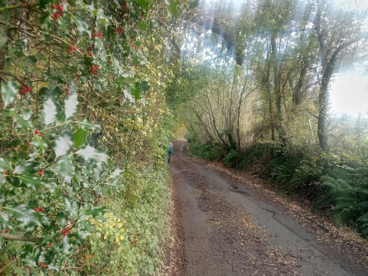
Holly bushes and their red berries are a common sight at this time of year and a favourite for Christmas wreaths. While out exploring east of Henfield, STEVE KISKO comes across a number of woodlands and hedgerows where holly bushes are in abundance.
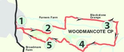
1. Start in Coopers Way car park in Henfield. Exit the car park and immediately opposite pass through an alleyway called Brick Lane. Make your way between properties, down steps and out into High Street. Turn left. In about 200 yards just before the mini-roundabout turn left between houses. Follow this footpath out on to a rough track and then in a further 100 yards onto a tarmac lane. Follow this alongside Henfield Common on the right and cottages on the left. In about 200 yards veer off into woodland to your right. After about 250 yards the footpath becomes a vehicle track. At the woodland edge reach a T-junction and turn left.
2. Walk through a farmyard. Continue ahead on a grassy track with the fence line of a horse paddock on your right. In about 100 yards follow the fence line around the right corner. In about 150 yards the footpath passes between bushes and into a grassy field. Keep right and pass to the left of a pylon. Exit the field corner and soon pass over a footbridge. In about 30 yards reach a T-junction and turn left. Follow the footpath through trees. After about 175 yards find a route ahead but slightly to the left to avoid a stream. You should soon spot a footbridge. Follow the woodland path for 150 yards until you rise a little onto a lane. Turn right. After about 200 yards it passes to the left of a property and narrows to a footpath between fields and hedgerows. There is a kissing gate along the way. After about 500 yards the footpath leaves this track to the left into a field and then immediately turns right to follow the right-hand edge. In only 50 yards leave the field at the corner over a stile and into a grassy area. Follow the hedgerow on your right and exit at the corner on the right, by the side of a field gate. The footpath now continues ahead close to the garden fence, above the continuation of the original track. Make your way down to a gate and out on to Blackstone Lane.
3. Cross over and immediately opposite go up steps, through a gate and alongside garden fences. Enter a field, turn left and follow the left-hand edge to reach the other side, by first turning right in front of houses, slightly right again and then left to reach the entrance of a property. Turn right. The footpath now continues between hedgerows. After half a mile pass through a gate and turn right. Follow a farm track for about 250 yards. Go through a gate, cross Blackstone Lane again, taking a footpath opposite. Immediately cross a footbridge and turn right in front of fencing. Soon turn left around the fence corner and follow the fence on your left. After about 200 yards pass through a gate into woodland. Try to stay going straight. In a further 250 yards just before the woodland becomes a field veer left and then in about 30 yards veer right so that you are in a field ahead but following trees on its right edge where there is a sunken pond. In about 250 yards reach a fence with a fingerpost and turn right into woods, now with the fence on your left.
4. Follow it for about 250 yards. Reach a footbridge and out on to a vehicle track. The footpath carries on ahead on grass with a fence on your left. In about 300 yards reach a T-junction and turn left. Walk between hedgerows. In about 100 yards turn right over a stile and into a field. Continue with a pylon on your right. Go over a footbridge, cross the next field, passed tall conifers and cross another stile. Cross the next paddock and over a stile through trees and onto a vehicle track. Turn left. Soon pass Swain’s farm shop on the left.
5. Just before the A281 turn right and walk through Henfield Common close to the road. Later ignore a vehicle barrier and keep left, close to the road beside a bank with the woodland on your right. Further on, the Common opens to grassland. Make your way on to bushes, pass through wooden barriers and turn right along a footpath veering right to more barriers. Ignore the immediate left but turn left on to the track you were on earlier beside cottages. Now retrace your steps back to the car park, by turning right along High Street, right through Brick Lane and cross Coopers Way to reach the end.
Distance/time: About 5 miles taking 2 hours. Public transport: Stagecoach has a bus no. 17 that goes between Horsham and Brighton, see www.stagecoachbus.com Car: Coppers Way car park, Henfield. Underfoot: Virtually the whole route is on public footpaths. It can be quite muddy in places and there seems to be several streams and spots of low-lying water, hence the number of footbridges. Thirsty work: Nothing en route so pack your own provisions. Plenty of shops in Henfield. One option is Swain’s farm shop, just before point 5. NOTE: It is recommended you don’t pick or collect any wild plants without the landowner’s permission. Maps: OS Explorer 122; OL 11.


Comments: Our rules
We want our comments to be a lively and valuable part of our community - a place where readers can debate and engage with the most important local issues. The ability to comment on our stories is a privilege, not a right, however, and that privilege may be withdrawn if it is abused or misused.
Please report any comments that break our rules.
Read the rules here