
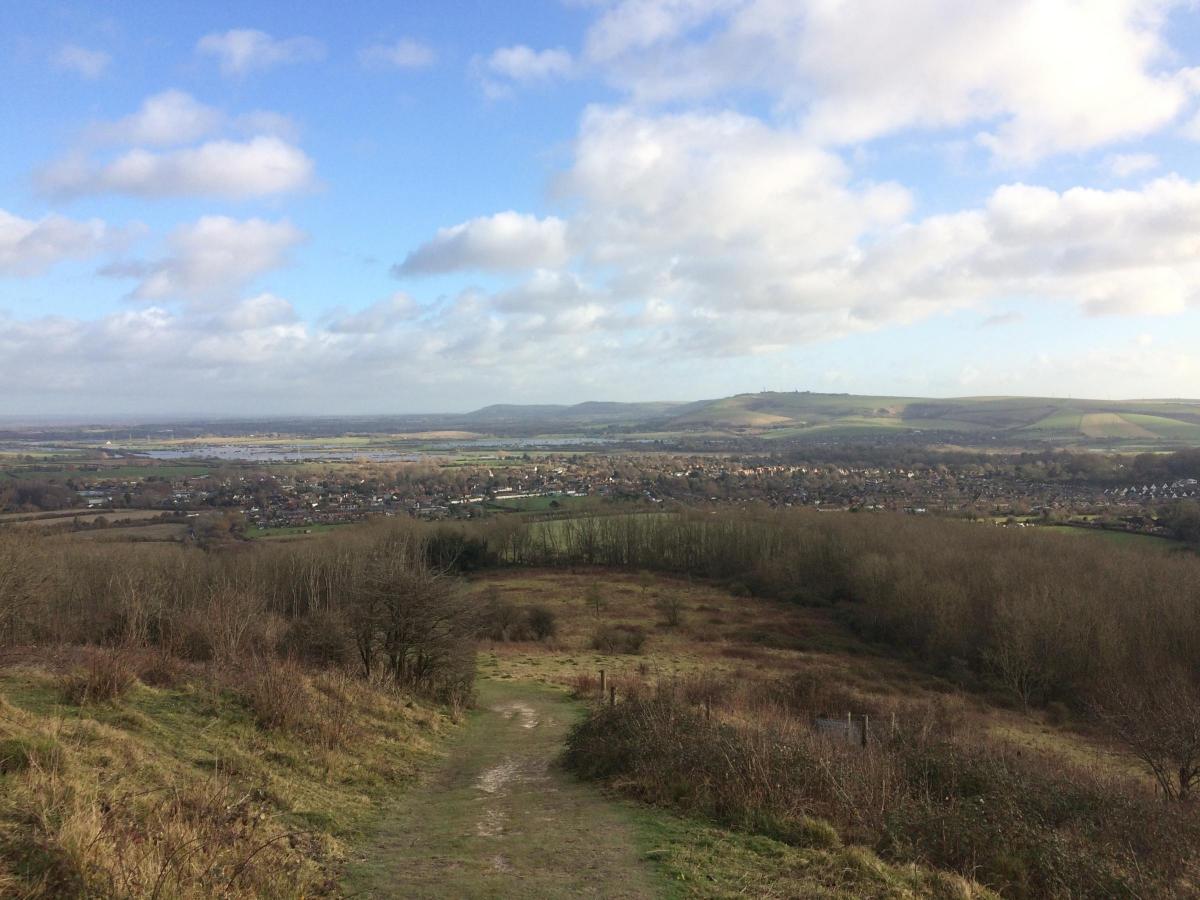
FROM high up on Steyning Coombe you can see across the waterlogged landscape of West Sussex without getting stuck in the mud. Natalie Leal follows a route around the historic village of Steyning before heading up to the Downs for some panoramic views, peace and quiet and even a spot of poetry.
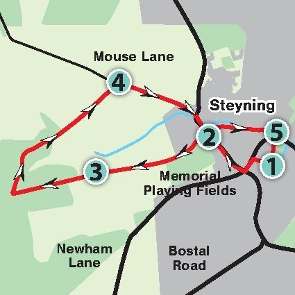
1. PARK up in the long stay car park adjacent to the church and playground. Leave the car park by the south-western corner following the alleyway along School Lane past Steyning Grammar school.
When you reach Church Street turn left. There are a number of dwellings along this street which date back to the 14th and 15th centuries. Part of the Grammar School dates back to 1614. You will shortly arrive at the High Street. Turn right here and continue past the shops along the main road for approximately 200 yards.
2. When you reach a set of stone steps signed for the Downs footpath, cross the road and turn left following the steps up the alley. At the top turn right. Continue straight along the road until you arrive at a footpath leading off the road and up to the South Downs. Follow the path as it leads steadily uphill until you arrive at a junction with a gate. Go straight ahead through the gate, passing the information board about Steyning Coombe, and then climb the steep hill towards the trees. At the top of this hill there is a bench which has a poetry box left there by the Steyning Downland Scheme for walkers to pause and pen their impressions of the stunning views over the village rooftops and the countryside beyond. Plenty of people have taken them up on the poetry challenge and it’s not hard to see why from this spot high up on the hill.
3. After a breather and a poem or two, keep going in the same direction passing through the next gate and heading into woodland.
Follow the footpath through the woods until, after a short distance, you reach the next gate. Turn right here following the bridleway downhill. This takes you steeply down through a patch of woodland used by mountain bikers. At the T junction go right continuing through the trees.
Just beyond a gate (which you should ignore) the path forks. Take the right hand fork here and you will soon emerge from the woods and into some farmland. Follow the bridleway down along the edge of the field (this section can get boggy after wet weather but is passable).
4. At the foot of the field you will arrive at a metal gate leading to a quiet road. Go though the gate and turn right into Mouse Lane. Directly opposite is a stone plaque with a poem carved into it. This was written by John Stanley Purvis, a First World War poet while he fought from a trench behind the Somme.
It speaks of his love for the lane leading from Steyning to Chanctonbury Ring, and walking along it you can see why he held such affection for the area. Follow Mouse Lane all the way to the end walking towards the main road. At the end of the lane you will see some workhouse cottages built in 1684 to house the poor of the parish until the introduction of the poor law in 1834. At the main road keep right and walk back towards the High Street. Once back at the steps you originally took up to the Downs turn left this time into Tanyard Lane. Follow this road all the way to the end, ignoring any turnings off to the left or the right.
5. At the T junction by Shooting Field cross the road and walk through the churchyard of the Parish Church of St. Andrews. It’s worth looking inside this impressive 11th century church built by monks following the Norman Conquest before you arrive back at the car park, the start and end point of the route.
Distance/Time: A circular walk of three and a quarter miles taking roughly two hours. By car: Steyning is on the A283 approximately ten miles north west of Brighton. The walk begins and ends at the long stay car park in the centre of Steyning which is signed from the High street.
Nearest postcode: BN44 3XZ. Grid Ref: TQ 17884 11235 By public transport: The nearest rail station is Lancing or Shoreham, both approximately 4.5 miles away. Buses run to the village.
Further travel details at www.travelinesoutheast.org.uk, phone 0871 200 2233. What’s Underfoot: Tarmac lanes and roads through the village. Mostly well-surfaced footpaths and bridleways through the countryside. Some short sections of the route can become boggy after rain.
Thirsty work: Plenty of places to eat and drink in the village of Steyning where the walk begins and ends. So you don’t get lost: OS Explorer map 122, plus a compass for general direction.


Comments: Our rules
We want our comments to be a lively and valuable part of our community - a place where readers can debate and engage with the most important local issues. The ability to comment on our stories is a privilege, not a right, however, and that privilege may be withdrawn if it is abused or misused.
Please report any comments that break our rules.
Read the rules hereLast Updated:
Report this comment Cancel