
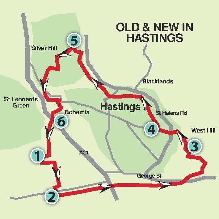
With the very wet weather continuing, John Harmer visits Hastings to avoid flooded fields and muddy footpaths by keeping to hard-surfaced paths to find things old and new around this historic town.
1 From Warrior Square rail station exit (south side), turn left up St John’s Road, then right down Church Road. At the T-junction, turn right continuing downhill and, in a short distance, turn left into Warrior Square.
2 Cross the main road at the zebra crossing to go up steps onto the promenade and turn left towards the pier. Originally built in 1872, it suffered a devastating fire in 2010. Rebuilt and re-opened in 2016, it closed again, was sold and re-opened again in 2018. See several new golden items placed there by the present owner.
Continue along the promenade for further three-quarters of a mile and notice a new metal sculpture on the seashore. Just past an amusement park cross the main road at light-controlled crossing and turn right. In a few paces turn left and, facing West Hill Lift, turn right along George Street with its typical Old Town character. At the end, bear left and, in a few paces, by a “Swan Avenue” sign, go up a narrow passageway. On coming to Hill Street, cross and turn right, following the footway alongside railings. Turn left to go up Cobourg Place by a sign “To Caves and Castle”, and follow the steps around to the left. On coming out into the open, turn right to go up steps and follow the tarmac path to Priory Road by the play area opposite from where there are good views across the town and sea.
3 Cross into Plynlimmon Road along the top of the green and bear left along a hard-surfaced track. In just over 100 yards, bear left down a long flight of steps to cross a road and continue down Noonans Steps. At the bottom, cross the road going straight ahead to cross the main road (A2101) at traffic lights. Continue along Waterworks Road, past Morrisons car park on the left; then bear right through an underpass under the railway and bear right to go over a zebra crossing into Alexandra Park.
4 Follow the path ahead, overlooking the lake on the right, go down steps and around to the right of a play area and then to the right of the cafe which may provide a good stop for a break. There are toilets across the bridge over to the right. Continue direction along the upper path for about 150 yards to cross Dordrecht Way. Follow the parkland path which runs alongside a stream on the right for a further half mile, passing to the left of a brick-built house and crossing a bridge over the stream.
On approaching a road, bear left uphill and left again to follow around the edge of Buckshole Reservoir. Continue around to the right to leave the park.
5 Turn left along Vale Road and next left into Eversley Road, then at the end turn right along Beaufort Road. In about 130 yards, turn left down a twitten leading back into Alexandra Park. Go over the bridge by Shornden Reservoir where wild fowl can usually be seen; then continue uphill to leave the park. Turn left, cross the main road to go along Clarence Road and, at the T-junction, turn left into Newgate Road, then right along Horntye Road. Take the second turning on the right into St Paul’s Road and go down the footway to the main road (A21).
6 Cross at the light-controlled crossing, turning left, then right by Sonrise Church building to go down Chapel Park Road for about 550 yards. Turn right down Ellenslea Road and through a twitten on the left, leading back to the rail station. Bus users can follow the route from point 1.
THE ESSENTIALS
Distance/time: Five miles/two and a half hours.
Public transport: Trains to St Leonards Warrior Square (frequent service on both Coastway and Charing Cross lines).
Bus users may wish to alight at Warrior Square and start from point 2.
Car: Use free on-street parking in unrestricted roads near Warrior Square Station.
Underfoot: Hard-surfaced urban footways.
No stiles but several steep ascents and descents with lots of steps.
Thirsty work: Café in Alexandra Park (between points 4 and 5) or pubs and restaurants in the town.
Maps: OS Explorer 124 or Hastings street map.


Comments: Our rules
We want our comments to be a lively and valuable part of our community - a place where readers can debate and engage with the most important local issues. The ability to comment on our stories is a privilege, not a right, however, and that privilege may be withdrawn if it is abused or misused.
Please report any comments that break our rules.
Read the rules here