
Spring has sprung but many of the rural footpaths are still waterlogged. John Harmer keeps to urban paths once more on this easy walk through lesser known parts of Hailsham, discovering spring flora in unusual places, plus an option to explore parkland with ponds and woodland.
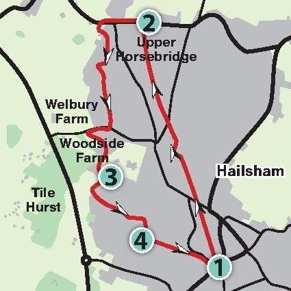
1 If arriving by bus, from Tesco in North Street or from Police Station in George Street, head towards South Road (A295) and turn left into the Cuckoo Trail car park.
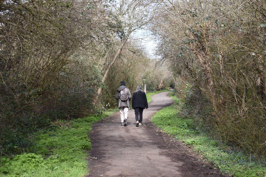
From the car park, go north through the subway along the Cuckoo Trail (CT) and stay on it for about one and a quarter miles. This is a picturesque and popular surfaced shared-use path for cyclists and walkers along the former Eastbourne to Heathfield railway track which was closed in the 1960s.
The name is derived from the local legend that the first cuckoo of spring is released at the annual Heffle (Heathfield) Cuckoo Fair in April.
Bear left under a bridge to stay on the CT; go under London Road Bridge and then through a cycle barrier.
On approaching a housing estate, turn right at a barrier to follow the sign for pedestrians. Pass through cycle barriers either side of an estate road; then go under Hawks Road Bridge, continuing on the CT.
2 Cross the main road (A271), using the light-controlled crossing and turn left along the footway, leaving the CT at this point. In about 250 yards, notice the derelict old mill building on the right, opposite London Road junction.
In a few paces beyond, cross the road at the traffic island and continue direction for a short distance, turning left into Cuckmere Rise. Look for a waymark post on the left and follow the direction arrow into Sheppy Walk, ignoring a bridleway fingerpost on the right.
Bear around to the right and, at a T-junction, cross and continue direction along a tarmac path between houses. Follow the estate road ahead and turn right along Rockall Drive. At a T-junction, turn left along Anglesey Avenue for about 550 yards.
On coming to a T-junction, turn right along Hempstead Lane. At a roundabout, turn left uphill along Gleneagles Drive, following this winding road for about a quarter of a mile. Just past a school sign, turn right into Holyhead Close.
3 Go straight ahead into Hailsham Country Park and follow the surfaced path down the left-hand side.
This recreational area covers approximately 22 acres and has been owned and maintained by the Town Council since 1992.
About halfway down the surfaced path turn left on a footpath into a housing estate.
If desiring to explore a little farther, go across the open green space to find two small ponds and woodland. This is also a good place for a picnic. Then return to the footpath leading into the housing estate.
Follow this path, crossing an estate road to continue opposite, slightly to the left. In about 200 yards the path bears first to the right; then to the left.
On coming to Woodpecker Drive, turn right along the footway for about 150 yards. Almost opposite Tilehurst Drive, turn right by a vehicle barrier bollard to go along a twitten and continue direction, ignoring another path on the right.
4 Emerge onto Western Road, turning left and, where it joins Summerheath Road, keep to the right alongside the Recreation Ground (another suitable place for a picnic).
Continue past Hailsham Free Church and, at the road junction, bear right.
Cross at the traffic island and into the Cuckoo Trail car park or turn left along the footway to the bus stops in North Street (northbound) or George Street (southbound).
Distance/time: Three and a half miles/one and a half hours (with an option to explore a little farther).
Public transport: Buses from Eastbourne, Hastings and Heathfield; alight at Tesco, North Street (northbound) or Police Station, George Street (southbound). Timetable information from Traveline: 0871 200 2233 or www.traveline.info
Car: Use Cuckoo Trail car park (free) opposite junction of South Road (A295) and Western Road or on-street parking in Western Road (by Recreation Ground).
Underfoot: Easy walking, mainly on level hard surfaces. No stiles; suitable for baby buggies.
Thirsty work: Pubs and restaurants in Hailsham Town Centre, before or after the walk.
Maps: OS Explorer OL25 (123), also Landranger 199; a compass for general direction would be useful.


Comments: Our rules
We want our comments to be a lively and valuable part of our community - a place where readers can debate and engage with the most important local issues. The ability to comment on our stories is a privilege, not a right, however, and that privilege may be withdrawn if it is abused or misused.
Please report any comments that break our rules.
Read the rules hereLast Updated:
Report this comment Cancel