

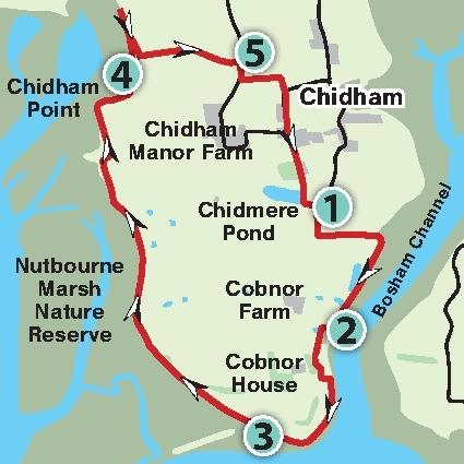
Explore the beautiful coastline around Chichester Harbour at Chidham. Natalie Leal follows a route down to Cobnor Point and around the peninsula, enjoying stunning views and wildlife along the way. The section at Cobnor Point along the shingle beach cannot be walked at high tide as it floods.
1. Park in the small amenity car park and climb the small set of steps at the far end leading out to a private road.
Turn left and follow the private road for a short distance until you reach a fingerpost. Turn left onto the signed footpath which runs along the edge of a field leading to the water’s edge.
When you reach the harbour with Bosham church on the opposite side, turn right and walk along the raised bank.
Continue along here until you reach the Christian Youth Enterprise Centre. There are fantastic panoramic views along this stretch over the harbour to Bosham and with the rolling South Downs behind you.
2. When you reach the Christian Youth Enterprise Centre take the right fork in the path and follow it downhill and round to the right.
Cross the quiet lane and then go over the footbridge and continue straight ahead following the footpath through an avenue of trees.
You soon come to a large house by a small boatyard. Stick to the footpath as it twists around to the left and returns back to the water’s edge. This soon leads to a well surfaced path which was laid in the 1980s to enable disabled people to access and enjoy the stunning surroundings (there is disabled car access to this point along the private road where you first started).
Continue on this path until you reach a set of steps leading down to the shingle beach.
3. This section cannot be walked at high tide as it floods so please do check the tide tables prior to setting out. Pass the gnarly, wind battered oaks along the shoreline and follow the route along the shingle beach.
If you are lucky you may even see a seal pop its head out of the water along here. Seals often visit Chichester Harbour and there is a bird hide along the way with information about the wildlife to be found here.
When you reach the next set of steps follow them up and continue along the raised bank. There are more great views here across the mud flats of Nutbourne Marsh Nature Reserve with the sights and sounds of oystercatchers, egrets and curlews, among others. At the fork by a noticeboard go right.
4. After approximately one mile you will reach a fence.
Follow the footpath as it leads onto the sea wall for approximately 75 yards and then take a sharp right down some steps and continue along the bottom edge of the field walking back on yourself.
This footpath skirts the edge of the field, soon turning left and heading inland (beware it can get muddy along here).
When you reach a footbridge, cross it and continue straight ahead along the narrow path between the tress and hedgerow.
At this time of year there are plenty of bright yellow primroses scattered under the trees to your right.
5. When you reach the lane turn right and then soon after at a fingerpost turn left following the footpath into a field. After approximately 30 yards turn left again, following the signed footpath through the middle of a field with the church spire ahead of you. At the next fingerpost turn right heading towards a metal gate and once at the road keep straight ahead.
At the T-junction turn left and follow the quiet lane past the village houses and back to the car park, the start and end point of the walk.
Distance/Time: A circular walk of five miles taking two and a half hours.
By car: Free parking at the Cobner Farm Amenity car park at the start of the walk. From the A27 take the turning signed for Fishbourne onto the A259. The turning for Chidham is on the left after approximately two miles and the car park is on this road after approximately one mile. Nearest postcode: PO18 8TD Grid Ref: SU 79303 03492.
By public transport: Some buses run to the area. Further travel details at www.travelinesoutheast.org.uk, phone 0871 200 2233.
What’s Underfoot: Footpaths, shingle and quiet lanes. Some footpaths can get muddy. The shoreline section cannot be completed at high tide so check the tide times before setting off: https://www.metoffice.gov.uk/weather/specialist-forecasts/coast-and-sea/beach-forecast-and-tide-times
So you don’t get lost: OS Explorer map OL8, plus a compass for general direction.


Comments: Our rules
We want our comments to be a lively and valuable part of our community - a place where readers can debate and engage with the most important local issues. The ability to comment on our stories is a privilege, not a right, however, and that privilege may be withdrawn if it is abused or misused.
Please report any comments that break our rules.
Read the rules hereLast Updated:
Report this comment Cancel