
This is a High Weald walk not too far from Crawley or the A23 road. It follows remote paths and dips into lonely valleys with burbling gills.
It is difficult to believe we are so close to intensive human activity but the six-and-a-half miles we cover are well away from busy roads and pass across the highlands and valleys of St Leonard’s Forest.
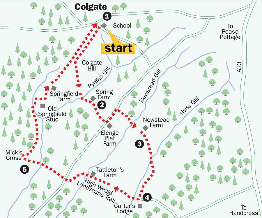
We begin the walk at Colgate, a tiny forest community which has a parish church, a primary school and a village pub – clearly there is more going on hereabouts than at first meets the eye.
1. From outside Colgate primary school, in Black House Road, cross the road and walk south-westerly on the rising, signed footpath.
The path rises for 250 yards to a minor road, beside a house called High Bisham, and continues straight down the road ahead. Walk down the road for 600 yards and just after the last house on the left, where the metalled road surface finishes, cross the stile in the fence on the left.
Walk over the top of Colgate Hill between paddocks and, having crossed stiles, drop in a few hundred yards toward woodland. Enter the woods and in a short distance come to Pyefall Gill. Cross the bridge and climb steeply up the opposite bank to a track. Turn left and follow the track around to the left, above Spring Farm, going right to a minor road.
2. Cross over the road, with Stone Edge Nurseries to the right, drop down the opposite path for 100 yards to a metal gate and then climb across the field ahead. At the top of the rise, the path goes half-left along a left fence edge, then on to Grouse Road, with Elenge Plat Farm opposite.
Turn left up the road for 350 yards and, just after a house called Lythmere, take the right signed footpath which drops through woodland, going right then left, towards Newstead Gill, another of the High Weald’s many valley-bottom streams.
By tracing the course of these streams on the Ordnance Survey map, it is possible to see they run into or out of large ponds.
These ponds invariably have man-made embankments or earth dams at one end, with an outflow race which would have led to a waterwheel. They are a legacy of ancient Wealden industries. From early fish ponds to iron-making, glass works, powder mills, wire and brass foundries and the milling of grain, the High Weald has been one of the industrial heartlands of southern England.
Cross a footbridge over the gill and climb steeply up the left field edge towards Newstead Farm on the left. The path negotiates its way beside the farm buildings to come out at a junction of tracks.
3. Do not take the southwesterly main farm bridleway on the right but go through a gate opposite, in an eastward direction, on the footpath that slopes to a junction of fields.
Pass through a metal gate and follow a sign half-right into the valley. Maintain direction across the field, pass to the right of a power cable pylon and cross a fence towards a footpath sign at the edge of woodland.
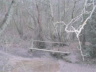
The path enters the trees, over a stile, where a big ear of woodland protrudes below Mount Noddy, and meanders around to the right for 300 yards, with the stream on the left. Do not cross the first bridge you come to but continue to a second one on the left which crosses over Hyde Gill.
Climb to a stile and turn right along the meadow edge. In a few hundred yards, beside a metal gate, the path gradually rises across the field, passing beneath a solitary sycamore tree, to a path sign on the skyline, beside a fence. Follow the left fence line south-westerly, right, to a farm track at Carter’s Lodge.
4. Turn right up Carterslodge Lane on a bridleway which descends and then climbs quite steeply across the top of the facing hillside and down the other side to cross Newstead Gill, beneath trees below Tattleton’s Farm.
On leaving the stream, the bridleway takes a rising left turn, traverses across an open meadow for 300 yards and then turns sharply right to climb towards Grouse Road.
Cross the road into Old Copse, descend through woodland and plantation towards Frenchbridge Gill.
Cross the bridge and climb for 400 yards through the continuing woodland to a confusing collection of path junctions at Mick’s Cross. (There is no doubt that Mick may have been frustrated, if not a little cross, had he to sort out which direction to take from the choice of five footpaths at this point. We shall never know his true feelings.) 5. Take the immediate right footpath which follows a sweeping turn and soon adopts a northerly direction between the trees. (At the time of writing, these woods were subject to extensive forestry operations. Footpath access is still possible but signs may be missing.) Keep to the slowly descending forest path for nearly three-quarters-of-a-mile to an obvious fork in the main track, one branch ascending to the left and the other maintaining level direction to the right.
Just before the fork, take a right turn (unsigned at the time of writing) for 100 yards, on a footpath beneath trees, to a double stile in the valley below Old Springfield Stud.
Cross the stiles and take the left path for 100 yards along the valley bottom. Cross a stile and turn right to cross a bridge and climb through the edge of woodland to the farm drive, beside a barn.
Turn left up the drive, passing Springfield Farm on the left, and continue north-eastwards to Forest Heights Farm.
From this point, the route joins our outward path, keeps direction to the left turn in the minor road and then takes the footpath we used earlier, descending back to the school, from where we began.
- Distance/time: Six-and-a-half miles, taking three-and-a-half hours.
- Start point: Grid Ref TQ232328.
- By car: Limited car parking in Colgate village.
- By public transport: Details from www.traveline.org.uk or call 0870 6082608.
- What's underfoot: High Weald walking, with some steep and muddy climbs. Not suitable for an off-road buggy and tough going with a baby backpack.
- Thirsty work: The Dragon pub, Forest Road, Colgate.
- So you don't get lost: OS Explorer map 134 and a compass for general direction.
For a larger version of the map see 'related links' above.


Comments: Our rules
We want our comments to be a lively and valuable part of our community - a place where readers can debate and engage with the most important local issues. The ability to comment on our stories is a privilege, not a right, however, and that privilege may be withdrawn if it is abused or misused.
Please report any comments that break our rules.
Read the rules here