
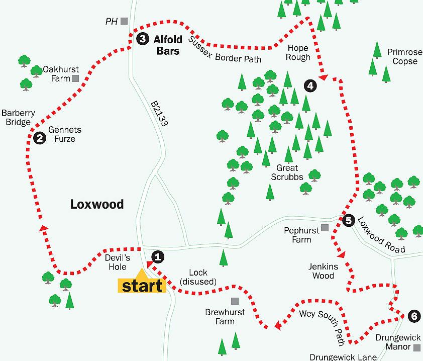
This seven-and-a-half mile walk takes you up to the East Sussex-Surrey border.
Beginning in Loxwood village, north-west of Billingshurst, the route follows parts of the Wey South Path and Sussex Border Path. The route also offers the opportunity to take in some of the county’s industrial past, as well as its pleasing undulations.
1. Begin in the centre of Loxwood on the B2133.
The start of the walk is on the drive to the left of the village post office – there is a bus shelter a few yards further left. This location, on the main road, is the junction of Guildford Road, which goes north, Loxwood High Street, which goes south, and Station Road opposite, with the village pond at the corner.
Leave the main road and take the drive west, beside the post office. In 25 yards, the drive turns right, indicating a bridleway, then slightly left, leading to a signed gravel footpath which you should take.
Go straight ahead between the new houses, through an open field for 300 yards to its far side.
The path then goes left, enters trees and begins to descend.
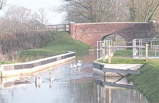
Down to the left, among the trees, is a boggy ditch shown on the map as Devil’s Hole. The path goes slightly right then left to a brick bridge over the Wey and Arun Canal.
Cross the bridge, turn right past the disused lock gates and take the towpath beside the overgrown, but still visible, canal. This is part of the Wey South Path and this walk follows it for just over a mile.
Continue along the path, which may be muddy, noting the old canal workings and bridges.
Pass through the gates before a slight rise, coming to a fourway junction at Barberry Bridge and Gennet’s Furze, which a notice on a tree advises is a wildlife area.
2. Turn right here (north-east), to join the East Sussex Border Path.
Proceed ahead, still in woodland, for 400 yards to another path junction. Go through the gate north-east across the meadow.
If sheep are grazing in this field, dogs should be kept on a lead.
In 150 yards, you come to Oakhurst Farm. Pass through the gate and walk ahead between the farm buildings past the farmhouse on your left.
The path drops slightly, veering left then right, past the entrance to kennels on the left.
It begins to gently rise, with houses on both sides, and comes to the B2133 road. Turn left along the grass verge for 100 yards to the Sir Roger Tichborne pub on the left (which appeared to be closed to business when this walk was planned). Cross the road and enter Pigbush Lane on the right.
3. Walk along the tarmac lane as it bends left then right uphill to its crest in 750 yards, with Songhurst House on the left at the top. Continue along the lane downhill, towards the farm buildings. Pass between them and, just after Keeper’s Cottage on your right, re-enter the woodland.
Follow the rising, sometimes muddy, path for about half a mile, through woods, turning left then right, before coming to a path junction at the top of Hope Rough. Take the rightsigned bridleway – not the footpath – and head south for about half-a-mile, past a meadow on the left and through woods, which contain some fine Wealden oak trees – just the sort for building warships to tackle an armada.
4. In 600 yards, take the obvious sharp-left footpath at a junction and continue uphill for about 100 yards, with a pond to your right.
Just under 50 yards later, take the signed footpath right, up, over then down a grassy knoll, with the pond still on your right, towards trees 300 yards ahead.
The path enters woods and, in 100 yards, joins a bridleway, turning left up a bank to a threeway signposted path junction.
Take the signed bridleway right (south) for the next half mile, through woodland to a layby on Loxwood Road.
5. Cross the road to the right of the layby and re-enter the footpath on the left, crossing a stile beneath the trees next to Pephurst Farm.
This path, through Jenkin’s Wood, joins a signed track from the right after 300 yards. Follow this track left for 150 yards, turning right at a fingerpost. After 100 yards, turn left across a causeway between two ponds to a track with two wooden huts opposite it.
Turn left here, up the signed, slightly-rising path, towards Drungewickhill Farm. Pass between the farm buildings to a secondary road, with a post box opposite.
Turn right, take the winding road downhill to a left bend which, in a few yards, crosses the re-constructed bridge over the Wey and Arun Canal.
The canal was built between 1785 and 1816 to connect London with Littlehampton via an inland waterway which joined the Wey and Arun river.
In recent years, restoration of the canal has been undertaken by the Wey and Arun Canal Trust. There are information points to explain the work and it is worth spending some time to appreciate the project.
For more information, visit www.weyandarun.co.uk.
6. Cross the bridge, taking the gate on the far side (south). Drop down right to the towpath and cross the newly-constructed Drungewick Aqueduct. Follow the towpath west for about one and a half miles, back to Loxwood.
It feels wonderful to stride along the path, part of the Wey South Path, seeing the restored sections of canal and the work to keep the Loxwood Link open, in progress. You may see the two barges – the Zachariah Keppel and John Smallpeice – which ply the canal.
On the towpath, 300 yards after Brewhurst Lock, is the Onslow Arms pub on the left, and the B2133 road, which leads back to the centre of Loxwood.
Turn right at the road, uphill, for 500 yards to the start point.
- Distance/time: Seven-and-a-half miles, taking about four hours.
- By car: Loxwood, on the B2133, between Billingshurst and Guildford has roadside parking. The start point is GR: TQ038315.
- By public transport: Call Traveline on 0870 608 2 608 or visit www.traveline.org.uk.
- What's underfoot: Undulating terrain, possibly muddy in places. Passable with a baby backpack but not suitable for a pushchair. Take care with children and animals near the deep canals.
- Thirsty work: The Onslow Arms at Loxwood. (The Sir Richard Tichborne in Pigbush Lane may be closed.)
- So you don't get lost: OS Explorer Map 134 and a compass.
For a larger version of the map, see 'related links' above.


Comments: Our rules
We want our comments to be a lively and valuable part of our community - a place where readers can debate and engage with the most important local issues. The ability to comment on our stories is a privilege, not a right, however, and that privilege may be withdrawn if it is abused or misused.
Please report any comments that break our rules.
Read the rules here