
The area to the west and north of Uckfield, bisected by trunk roads, including the town bypass, does not look very promising for walkers. It was therefore a pleasant surprise to sample the richness and variety of the landscape on this fairly easy walk through the countryside between Uckfield and Maresfield.
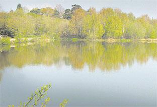
It passes through woods, crosses sandy heathland and includes a loop through the delightful Woodland Trust area of Lake Wood, where sandstone outcrops overlook a large ornamental pond.
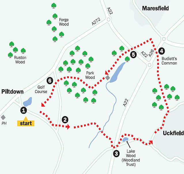
1. From Piltdown Pond turn left, eastwards, along the road. After about 250 yards, go left along a signed path through a belt of scrub onto a golf course and turn right along the edge of the playing area.
Pass to the right of the twelfth tee.
Immediately bear half-right into woodland to follow an indefinite path which winds through scrub, never far from a left-hand fence and hedge, for 100 yards or so to join a road.
2. Follow the private road to Fair Hazel opposite. Where the drive ends, go ahead between sheds and across a field without change of direction. Go through a gap and immediately fork half-right across the middle of a field. Cross two footbridges in quick succession and follow a woodland path which finally bears right beside the Uckfield bypass perimeter fence to join a road.
3. Turn left across the bypass and immediately left over a stile into Lake Wood. There are various paths to explore within this picturesque area, but I suggest bearing right shortly to follow a path which skirts to the left of a large pond. The path tunnels through a sandstone outcrop at one point before veering right and climbing to rejoin the road you have just left, about 300 yards further on.
Turn left and continue along the road until you can fork left along Snatts Road. After a little more than half a mile, turn left over a stile and follow a fenced woodland path.
Where the path opens out, go ahead across a drive and along a wide grassy path across Budlett’s Common, where an elaborate wooden causeway carries you across a boggy area. Once out into a field veer half-right.
4. Cross the A26 with care, go right for a few yards along the grass verge, then left over a stile and slightly right across rough pasture.
At a track go right for 20 yards then half-left downhill along the left edge of a neglected area.
Cross a footbridge, go slightly left for a few yards to pass through a wide hedge gap and then climb along a right field edge. In the field corner go over a stile and then left along a left field edge and on within a belt of trees.
Where the main path bears right into a more open area of woodland, fork left along a narrower path which runs parallel to the left edge of the wood.
5. Cross the A22, directly if traffic permits, or via a pedestrian subway, which isn’t very convenient or accessible, about 200 yards to the right, and continue through woodland before skirting to the left of a pond, one of a string of former hammer ponds, to join a drive where you should turn left.
You are shortly directed into a fenced path which runs parallel and to the right of the drive as it passes another large pond. It then skirts to the right of a large property before entering Park Wood.
Follow the carefully waymarked path for two thirds of a mile through this large area of woodland, ignoring all other unmarked paths, finally emerging to join a road where you should turn left.
6. After walking a little more than 100 yards, just short of a row of houses on the right, turn right and go along a gravel track which leads on to Piltdown Golf Course.
The path from here across the golf course is now quite difficult to follow with accuracy. Though partially waymarked, some of the directional yellow arrows are misleading so you will need to follow the walk description with extra care.
Where the track divides after 60 yards, fork left behind the houses.
Just past a seat, follow a faint track ahead as it diverges at about 40 degrees from the hedge on the left. Pass a rather superfluous notice – “You are now entering a golf course” – where there is a waypost and bear slightly left across a fairway to the next post.
Continue through a group of trees, passing two more posts. Maintain direction to another post and, ignoring the direction of the arrow on this post, bear right to another post, in sight.
Here bear half-left across another fairway, heading south. After 100 yards turn right at another post and head for the trees ahead where you will find yourself back on your outgoing route along the edge of the golf course.
Turn right along the edge of the playing area until, after a few yards, you can go left on a path through the trees to join a road. Turn right, retracing your outgoing route back to the start.
- Distance/time: Five miles, taking two hours.
- By car: From Piltdown, west of Uckfield on the A272, turn south along a road which leaves the main road a little to the east of the Piltdown Man pub. Park beside Piltdown Pond on the left of the road at GR 443222.
- By public transport: Hourly weekday bus service to Piltdown from Uckfield or Haywards Heath.
- What's underfoot: Easy walking, mostly along good paths. Two busy main-road crossings.
- Thirsty work: Pubs at Piltdown and Maresfield, both about a quarter-of-a-mile off the route.
- So you don't get lost: OS Explorer 135.
For a larger version of the map, see 'related links' above.


Comments: Our rules
We want our comments to be a lively and valuable part of our community - a place where readers can debate and engage with the most important local issues. The ability to comment on our stories is a privilege, not a right, however, and that privilege may be withdrawn if it is abused or misused.
Please report any comments that break our rules.
Read the rules here