
Crabtree is a community that sits astride the Cowfold to Horsham road, surrounded by Wealden woodland and a network of paths and bridleways, which offer exploration possibilities for walkers.
On this expedition, we walk some little-used paths which traverse the area, passing isolated dwellings and crossing silent meadows, bridges and waterways.
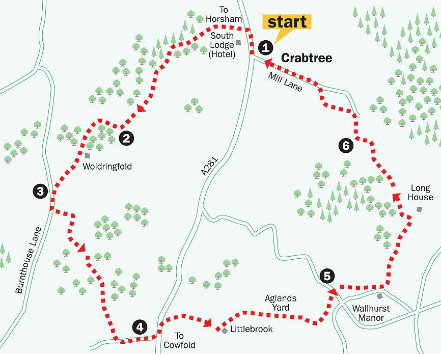
1. From the junction of the A281 road and Mill Lane, walk north up the road to a point just after the entrance to South Lodge Hotel, which is opposite. Locate the signed public bridleway and carefully cross to enter the shrub cover, outside the hotel’s boundary wall.
Follow the path through shrubbery to a drive. Keep to this for about one third of a mile through mixed woodland, taking no turnings off. The bridleway arrives at a junction. Take the left fork on the footpath along the drive, heading south. Continue for 250 yards to arrive at some isolated cottages.
Walk to the far side of the second cottage frontage and, at the path junction, take the left turning, descending through scrub. (Do not take the first footpath turning on the left opposite the cottages but continue to the next left turning, a few yards ahead.) The descending path clears the scrub to pass a lone bungalow on the right of the track. Keep to the main track and, in 200 yards, pass through a narrow strip of trees, climbing to a three-way junction in a further 200 yards.
2. Turn right, towards the houses of Old Woldringfold and walk past them on a drive, turning left after the final residence, climbing to a drive junction.
Continue ahead on the opposite footpath through a copse, signposted to stables, to arrive at a hilltop drive above Woldringfold. As the drive veers to the right, cross left into a field, as signed, descending to pass between two oaks.
Enter the next field through a gate, keeping to a line of trees on the right. Maintain direction to the lower, far right, field corner, beside the isolated West Lodge cottage. Cross into Burnthouse Lane, and turn left.
3. Walk along the lane for 200 yards and, after passing beneath power cables and before a cottage, take the plank bridge and footpath on the left. Enter the roadside scrub, climbing to the right for a few yards and then left into a field.
Climb along the field edge. Pass through a hedge opening to a convergence of three footpaths. Turn right along the hedgeline to a field corner and four-way junction in 200 yards.
Pass through a hedge opening, going half-left to cross a stile and plank bridge in 250 yards, into the next field. Go along the left hedgeline for 50 yards, turn left in a copse between two ponds and head off half-right to the far right field corner.
At the corner opening, turn right along the next left field-edge. In 100 yards, about 50 yards before the field corner, turn left into the copse and immediately turn right, following the descending path to a stile.
Maintain direction down the next field to a path junction, with a footbridge ahead.
Do not cross the bridge but turn left along the field-edge to the road in 300 yards.
4. Turn left along the road for 150 yards and cross with care to a stile next to the gate leading to Littlebrook, adjacent to the ornate gates of Brook Place. Walk along the metalled drive for 200 yards, passing a left footpath turning, and continue ahead for 75 yards to cross a stile in the right hedgeline.
Immediately turn left in the next field, passing beside Littlebrook, which is on the left. At the end of the hedgeline turn left, descending to a metal gate and crossing a stream gully.
At a path junction, continue ahead through the undergrowth, beneath power cables, towards the opposite trees. Climb to the right through the narrow stand of trees, crossing a plank bridge and stile into a field.
Follow the left field-edge for nearly half-a-mile, passing Aglands Yard at the mid point. At the end of the fence-line, go through an opening and turn right to a field corner.
Go left from the corner for 100 yards to a three-way path sign, turning left over the field to cross a stile in the facing fence. Turn left up the field to a gate at the corner, leading to a minor road.
5. Take a few paces left and turn right, onto the ongoing footpath.
This path skirts around the northern boundary of Wallhurst Manor to arrive at a left turning. Climb northward along the right edge of two fields, to a corner stile.
Continue ahead through a copse for 200 yards to a gate at the edge of a sloping meadow. Climb across the meadow to the path sign on the skyline.
With Long House to the right, turn left for 100 yards to a stile and then turn right, taking a leftward line towards the treeline at the bottom of the field in 250 yards, noting the mid-way marker post.
Descend steeply through a strip of woodland, cross a bridge and climb to a stile.
In the next field, cross half-left to the opposite stile. Cross into a lane, take few paces left and turn right along a field-edge. At the field corner in 100 yards, enter trees and turn left, descending steeply to a drive.
6. Turn right over a bridge, climbing up the drive to a four-way path junction in 200 yards. There is a cottage behind hedgerow on the right.
Take the stile on the left, crossing over a field through a fence opening and continue to a stile in 150 yards. Take a few paces right and then turn right up a track to arrive at Mill Lane in 100 yards.
Turn left along the lane for one-third-of-a-mile, passing the residences of Crabtree, back to the starting point of this walk.
- Distance/Time: Five-and-a-quarter miles taking two-and-three-quarter hours.
- By Car: Crabtree is on the A281 Cowfold to Horsham road, one-and-three-quarter miles north of the road junction in Cowfold. There is limited roadside parking on the A281 and in Mill Lane. Start point: Grid Ref TQ220253.
- By Public Transport: There is a bus stop close to the start point. Details from www.traveline.info or phone 08712 002233.
- What’s underfoot: Undulating Wealden walking with stiles, plank bridges and some undergrowth. Some short but steep climbs and descents, which may be boggy after heavy rain. A bit tough with a baby backpack, not possible with a baby buggy.
- Thirsty work: The Crabtree pub, a few yards south of Mill Lane, Crabtree.
- So you don’t get lost: OS Explorer map 134 and a compass for general direction.
For a larger version of the map, see 'related links' above.


Comments: Our rules
We want our comments to be a lively and valuable part of our community - a place where readers can debate and engage with the most important local issues. The ability to comment on our stories is a privilege, not a right, however, and that privilege may be withdrawn if it is abused or misused.
Please report any comments that break our rules.
Read the rules here